the Creative Commons Attribution 4.0 License.
the Creative Commons Attribution 4.0 License.
 | 04 Aug 2022
Late Cretaceous–early Palaeogene inversion-related tectonic structures at the northeastern margin of the Bohemian Massif (southwestern Poland and northern Czechia)
Andrzej Głuszyński
Paweł Aleksandrowski
A brief, regional-scale review of the Late Cretaceous–early Palaeogene inversion-related tectonic structures affecting the Sudety Mountains and their foreland at the NE margin of the Bohemian Massif is presented and complemented with results of new seismic studies. The Sudetes expose Variscan-deformed basement, partly overlain by post-orogenic Permo-Mesozoic cover, containing a wide spectrum of tectonic structures, both brittle and ductile, in the past in this area referred to as young Saxonian or Laramide. We have used newly reprocessed legacy seismics to study these structures in the two main post-Variscan structural units of the area: the North Sudetic and Intra-Sudetic synclinoria. The results were discussed together with regionally distributed examples of tectonic structures from quarries and underground mines as well as those known from the literature. The Late Cretaceous–early Palaeogene tectonic structures in consecutively reviewed Sudetic tectonic units, from the north to the south, typically include gentle to moderately tight buckle folds, locally of detachment type or fault-related and high-angle reverse and normal faults, as well as low-angle thrusts – often rooted in the crystalline basement. The structures termed grabens in the local literature are at the same time frequently interpreted as bounded by reverse faults (hence we use here the term “reverse grabens”) and typically reveal a strongly synclinal pattern of their sedimentary fill. The top of the crystalline basement, as imaged by seismic data in the North Sudetic Synclinorium below the faulted and folded cover, is synformally down-warped with a wavelength of up to 30 km, whereas on the elevated areas, where the basement top is exposed at the surface, it is tectonically up-warped (i.e. antiformally buckled). The compressional structures typically show an orientation that fits the regionally known Late Cretaceous–early Palaeogene tectonic shortening direction of NE–SW to NNE–SSW. The same applies to the regional jointing pattern, typically comprising an orthogonal system of steep joints of ca. NW–SE and NE–SW strikes. All the reviewed structures are regarded as being due to the Late Cretaceous–early Palaeogene tectonic shortening episode, although some of the discussed faults with a strike-slip component of motion may have been modified, or even produced, by late Cenozoic tectonism.
- Article
(36584 KB) - Full-text XML
- BibTeX
- EndNote


During Late Cretaceous to early Palaeogene times, compressional tectonic structures developed over vast areas of western and the northern part of central Europe (e.g. Ziegler, 1987; Ziegler et al., 1995; Navabpour et al., 2017; Kley, 2018; Nádaskay et al., 2019; Malz et al., 2020; Voigt et al., 2021). They are currently interpreted as being due to collisional interaction of the Iberian mass with continental Europe and the resultant propagation of far-field compressional stress (Kley and Voigt, 2008), which brought about widespread inversion of Permo-Mesozoic basins. In Poland and easternmost Germany (e.g. Krzywiec, 2002, 2006; Mazur et al., 2005; Krzywiec and Stachowska, 2016; Kley, 2018) the resultant map-scale tectonic structures (Fig. 1) are mostly NW–SE-trending, large-scale, gentle folds up to 1000 km long, ca. 150 km wide and up to at least 3 km high (e.g. Pożaryski, 1979). The Mid-Polish Swell (or Anticlinorium), spanning the entire length of Poland's NW–SE diagonal from the Baltic Sea to westernmost Ukraine, is the most spectacular example of such a structure. To the SW of the Mid-Polish Swell there is the Szczecin–Łódź Trough (Synclinorium) and a successive elevated structural element, occurring at the NE margin of the Bohemian Massif, in the borderland between Poland and Czechia. This complex element combines the Fore-Sudetic Homocline and the Sudetic area, composed of the Fore-Sudetic and Sudetic blocks (Fig. 1). The latter tectonic units are the principal object to be presented in this paper, the goal of which is to give a brief overview of the wide spectrum of structural effects produced by the Late Cretaceous to early Cenozoic trans-European compressional event at the NE margin of the Bohemian Massif.
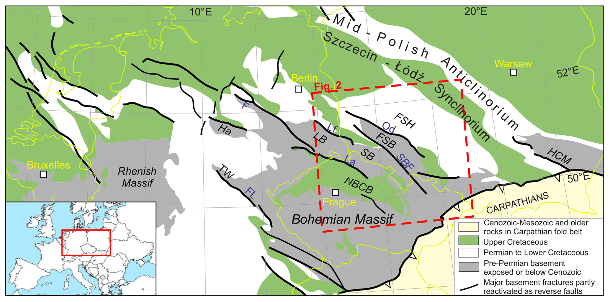
Figure 1The main Late Cretaceous–early Palaeogene tectonic structures in central Europe. Modified after Kley and Voigt (2008). Abbreviations: F – Flechtingen High; FL – Franconian Line; FSB – Fore-Sudetic Block; FSH – Fore-Sudetic Homocline; Ha – Harz Block; HCM – Holy Cross Mountains; La – Lusatian Thrust; LB – Lusatian Block; Lf – Lusatian Main Fault; NBCB – North Bohemian Cretaceous Basin; Od – Odra Fault; TW – Thuringian Forest; SB – Sudetic Block; SBF – Sudetic Boundary Fault.
An important part of this review is based on recently reprocessed legacy seismic data from the central areas of the Sudetic region. The other presented examples of tectonic structures supply the wide regional context for the seismic results and come either from our own field work or from descriptions made by other authors, though sometimes interpreted by us in a different way. Although the tectonic structures that formed at the turn of Cretaceous and Palaeogene times in the Permo-Mesozoic strata obviously must have developed also in the Variscan basement, they are – in general – difficult to distinguish from the older structures. Therefore, the scope of this paper is mostly limited to the tectonic phenomena that occur in the post-orogenic (post-Variscan) Permo-Mesozoic strata, though, in places also in the late-orogenic upper Carboniferous. An overview of the Late Cretaceous–early Palaeogene deformation structures in the Sudetic area is presented in this paper, mostly in their regional context and in reference to particular structural units of the Sudetes, moving from the north to the south across the area.
The Sudetes (Polish and Czech name: Sudety), low-topography mountains located on the northeastern margin of the Bohemian Massif, together with the southern part of the Silesian–Lusatian Plain share the same pre-Cenozoic geological composition and structure and – in the geological sense – have for decades usually been considered collectively as the Sudetic area or region or simply as the Sudetes (e.g. Aleksandrowski and Mazur, 2002; Mazur et al., 2006, Kroner et al., 2008). The differences in topography – mountainous versus lowland – are due to the splitting of the Sudetic area into two tectonic blocks: the currently downthrown and mostly flat or hilly Fore-Sudetic Block in the northeast and the elevated, mountainous Sudetic Block in the southwest (Fig. 1). The Sudetes constitute the northeasternmost segment of the Central European Variscan internides, exposing crystalline basement of strongly deformed and metamorphosed late Neoproterozoic to Carboniferous rocks abundantly intruded by Carboniferous granites (e.g. Mazur et al., 2006, 2007, 2020). The Variscan Orogenic Belt formed in Europe in approximately Middle Devonian to late Carboniferous times and currently extends from Portugal and Spain across Britain, France and Germany to Czechia and Poland. It continues further to the southeast to Romania and Anatolia and is also represented by numerous dismembered internal massifs within the Alpine–Carpathian orogenic system. Its formation was contemporaneous with the Acadian and Alleghenian orogenies in the Appalachians, whose particular major tectonostratigraphic zones define links to those of the European Variscan Belt across the Atlantic (e.g. Matte, 2001; Martínez Catalán et al., 2002; Kroner et al., 2008). In the Sudetes, the main tectonostratigraphic domains of the European Variscides (the Moldanubian, Teplá–Barrandian and – particularly – Saxothuringian) find their continuation (e.g. Martínez-Catalán et al., 2020).
The Variscan basement rocks are partly overlain by syn- to late-orogenic Carboniferous intramontane basins and remnants of the now much eroded post-orogenic Permo-Mesozoic sedimentary-volcanic cover. To the north, in the North Sudetic Synclinorium, there occur lower Permian red beds with volcanics and upper Permian Zechstein facies carbonates, sulfates and clastics, averaging ca. 1000 m in thickness. The Lower Triassic Buntsandstein of variegated sandstones, totalling ca. 600 m in thickness, is capped by Röt dolomites and later Keuper evaporites and Muschelkalk limestones (e.g. Baranowski et al., 1990; Chrząstek and Wojewoda, 2011). To the south, in the Intra-Sudetic Synclinorium, lower Permian red beds and shales with volcanics up to 1250 m thick are followed by upper Permian, mostly fluviatile sedimentary rocks. The Lower Triassic is represented by the Buntsandstein facies, which does not exceed a few tens of metres in thickness (e.g. Dziedzic and Teisseyre, 1990). The Sudetic area is described in the literature to have been emergent in its most part during the Triassic (e.g. Feist-Burkhardt et al., 2008). In the Jurassic and Lower Cretaceous times the Sudetes must have also remained emergent, as no Jurassic and Lower Cretaceous strata are known from the area. In the Late Cretaceous, however a system of sedimentary basins formed along reactivated Variscan, mostly NW–SE-trending shear and fault zones over the northern Bohemian Massif, accumulating an at least 1000 m thick succession of shallow marine sediments (e.g. Wojewoda, 1997; Scheck et al., 2002; Uličný et al., 2009). The Intra- and North Sudetic Synclinoria were filled with Cenomanian, Turonian, Coniacian and Santonian sandstones, marls and siltstones (Wojewoda, 1997).
The Sudety Mountains acquired their present-day mountainous relief due to Neogene uplift of the Sudetic Block in front of the then actively growing Alps and Carpathians (e.g. Żelaźniewicz and Aleksandrowski, 2008; Jarosiński et al., 2009; Żelaźniewicz et al., 2011). This uplift affected an area mostly planated during Palaeogene and early Miocene times, following the earlier, Late Cretaceous–early Palaeogene more prominent uplift, which at that time had occurred over a broader area, including also the Fore-Sudetic Block (Fig. 1), which at present is downthrown along the Sudetic Boundary Fault (e.g. Cloos, 1922; Teisseyre, 1957; Oberc, 1972).
The Late Cretaceous–early Palaeogene uplift that occurred concurrently with or slightly postdated the trans-European compressional event related to the Africa–Iberia and western to north-central Europe convergence at ca. 86–70 Ma (Kley and Voigt, 2008) exhumed the Variscan basement from below the post-Variscan, uppermost Carboniferous through Permo-Mesozoic cover and left the entire Sudetic area tectonically elevated with respect to the adjoining depressed areas: the Fore-Sudetic Homocline to the northeast and the North Bohemian Cretaceous Basin to the southwest. Within both these tectonic units much of the deformed Permo-Mesozoic post-Variscan sedimentary fill has been preserved. Among the Late Cretaceous–early Palaeogene contractional structures in the Sudetes that have escaped erosion, are the North and Intra-Sudetic synclinoria, representing the largest objects of that kind (Fig. 2). For over a century, the Sudetes have been considered a part of the classical area in central Europe, in which the term “Saxonische Tektonik” (compare to Kley, 2013) was applied to deformation structures, mostly fault-related, observed in the Permo-Mesozoic sedimentary basins. In the older literature these contractional structures were most often ascribed specifically to the “young Saxonian” (Closs, 1922; Beyer, 1939; Oberc, 1972, 1977) or “Laramide” tectonism (Oberc, 1972, 1977).
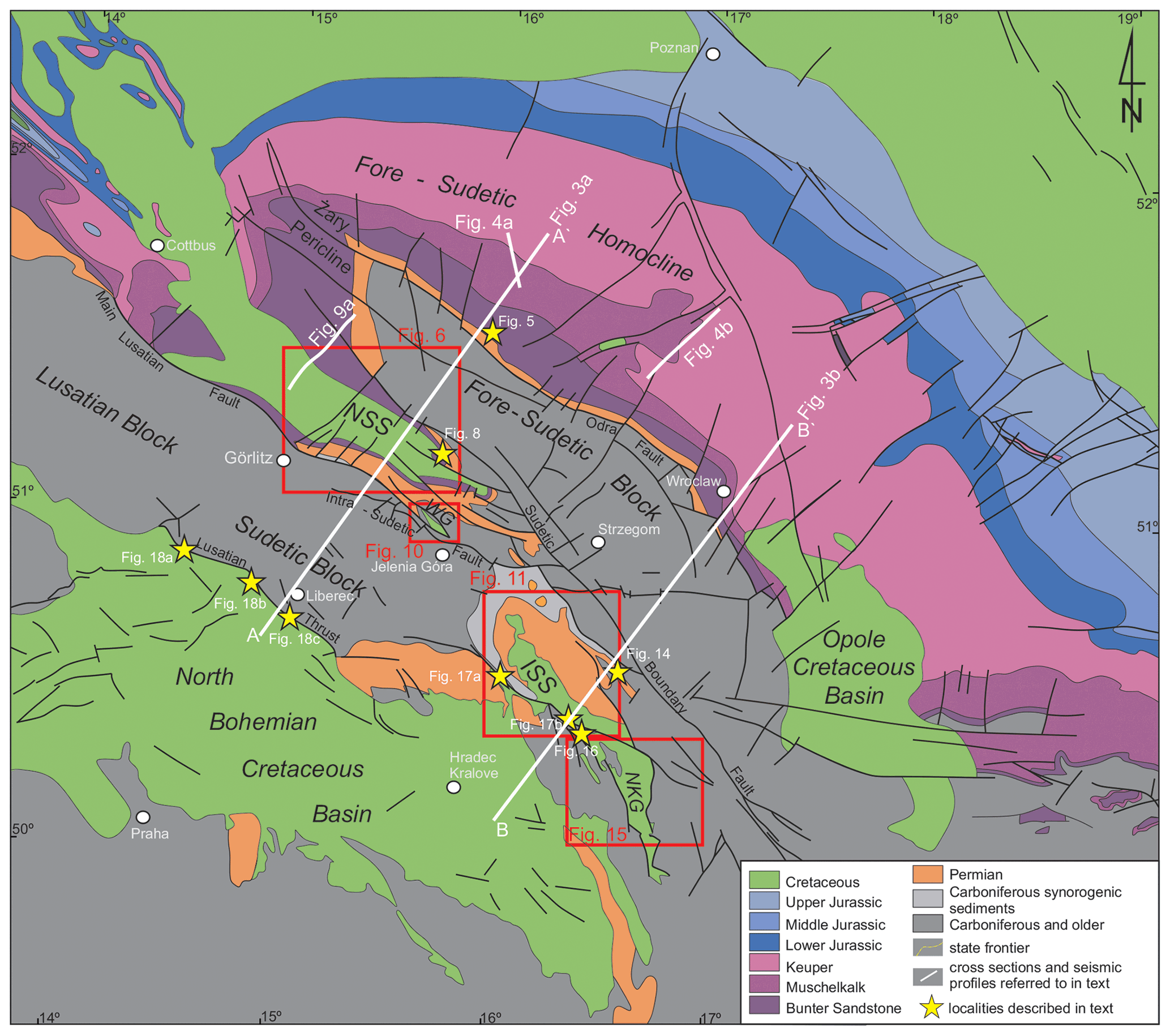
Figure 2Geological map without Cenozoic of NE margin of the Bohemian Massif and its surroundings in SW Poland and N Czechia (simplified after Dadlez et al., 2000). ISS – Intra-Sudetic Synclinorium; NKG – Nysa–Králiky Graben; NSS – North Sudetic Synclinorium; WG – Wleń Graben. Red boxes show location of Figs. 6, 10a, 11 and 14.
The concise regional, though not fully systematic, review of the tectonic structures of likely Late Cretaceous–early Palaeogene age presented in this paper is based (1) on the authors' own analysis and structural interpretation of the newly reprocessed seismic reflection data located in the two key areas in the Sudetes containing the most complete post-Variscan sedimentary record and (2) on structural field data of the present authors or (3) on data coming from critically assessed literature descriptions. We have also used data from exploration boreholes drilled in the last 5 decades, prospecting for copper and coal deposits in the North Sudetic and Intra-Sudetic synclinoria, respectively.
The analysed seismic data were acquired by mining and oil companies in the late 1970s (1976–1980) in the North Sudetic Synclinorium and in the early 1990s (1991–1993) in the Intra-Sudetic Synclinorium (Fig. 2). We received them as raw seismic data (field data, partly pre-processed, reloaded to discs from original magnetic tapes) and the accompanying paper printouts. These seismic data are unique at the scale of the entire Sudetes and the source of valuable information on the structural geology of the Permo-Mesozoic succession in both main Sudetic synclinorial units.
The reprocessing of, in total, ca. 650 km of seismic profiles was carried out in 2019, using an up-to-date oil-industry software (Głuszyński and Smajdor, 2020). The new processing included post-stack time migration (PostSTM), while the pre-stack time migration stage (PreSTM) procedure was also applied to some of the profiles. No time–depth conversion was, however, attempted because of too scarce a coverage of the area with appropriate drill hole data. As complementary material we also used an analogue paper print version of a seismic profile from the vicinity of Broumov in Czechia and also some seismic profiles from the Fore-Sudetic Homocline. The largest part of the structurally interpreted seismic profiles is presented in this paper. Our structural interpretation of these profiles provides entirely new material showing the tectonic style and geometry of the compressional tectonic structures affecting the post-Variscan sedimentary cover along the NE margin of the Bohemian Massif and allows for some inferences as to the mechanics of their formation. An equally important part of the paper, aimed at giving its readers overall information on the distribution and genetic and geometrical diversity of the tectonic structures that formed or evolved under the Late Cretaceous–early Palaeogene compressional regime, is depiction and short description of a selection of such structures exposed in natural outcrops and in active mines and quarries throughout the entire Sudetic area or its direct vicinity. This material is either our own or is based on critically evaluated literature accounts.
4.1 The northeastern margin of the Sudetes: transition to the Fore-Sudetic Homocline
Directly northeast of the Sudetic area, separated by the Middle Odra Fault Zone, the Fore-Sudetic Homocline extends (e.g. Kłapciński et al., 1984; Kroner et al., 2008; Żelaźniewicz et al., 2011). It is defined by gently (1–5∘) NE-dipping Permian to Mesozoic strata (Figs. 2 and 3) on top of Variscan-folded Carboniferous (e.g. Mazur et al., 2006, 2010), representing the SW limb of the Szczecin–Miechów Synclinorium of the Polish–German Basin. The Permian–Mesozoic succession constitutes the fill of the extensive Polish–German Basin and unconformably overlies the Carboniferous fold-and-thrust flysch belt of the Variscan externides (e.g. Mazur et al., 2010, 2020).
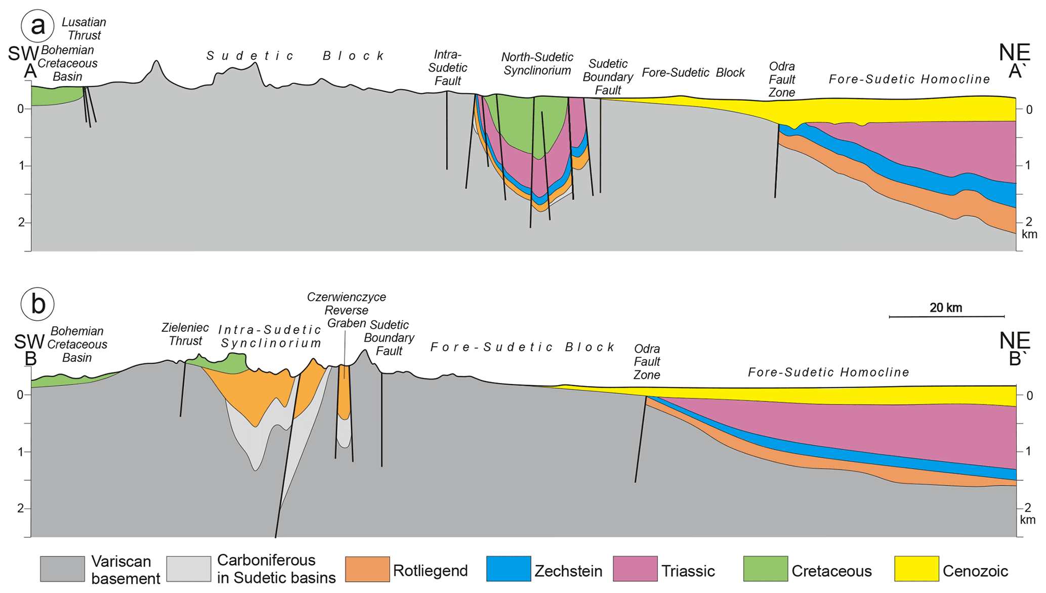
Figure 3Schematic regional cross-sections across the Bohemian Massif NE margin (highly vertically exaggerated). Location in Fig. 2.
The Permo-Mesozoic strata in the southern part of the Fore-Sudetic Homocline are very gently folded and in a few places affected by steep to low-angle reverse faults (Fig. 4). In the close vicinity of the NW–SE-trending Middle Odra Fault system, however, in galleries of ca. 0.5–1.2 km deep mines of the Legnica–Głogów Copper District, a rich inventory of contractional and, also, extensional tectonic structures occurs in the base Zechstein–top Rotliegend ore-bearing formation, containing clayey shale, carbonates, anhydrite and rock salt, apart from sandstones. These structures typically include thrust faults, accompanied by bedding-parallel decollements, as well as folds, all indicative of NE–SW-directed tectonic shortening. The meso-scale structures can be studied directly on the galleries' walls (Fig. 5; see e.g. Salski, 1965, 1968; Oberc and Salski, 1968; Dumicz and Don, 1977, 1990; Markiewicz and Szarowski, 1990; Żelaźniewicz and Markiewicz, 1991). Larger structures appear on mining maps as a complex network of faults, whose pattern reflects reactivation of a few major and numerous minor NW–SE-trending fractures propagating upwards from the Variscan basement, accompanied by a number of relatively large WSW–ENE en echelon fractures (compare to Markiewicz, 2007), the latter most probably formed due to a Late Cretaceous–early Palaeogene (or late Cenozoic?) sinistral strike-slip activity of the major NW–SE faults.

Figure 4Two seismic profiles from the Fore-Sudetic Homocline (location in Fig. 2) showing very gentle folds in Triassic and Permian (Rotliegend not marked). Note steep to low-angle mainly reverse faults. The anticlines are structural traps for hydrocarbons, with gas fields known in Rotliegend strata (Grochowice gas field in Fig. 4a). Please note the different scales of the two profiles.
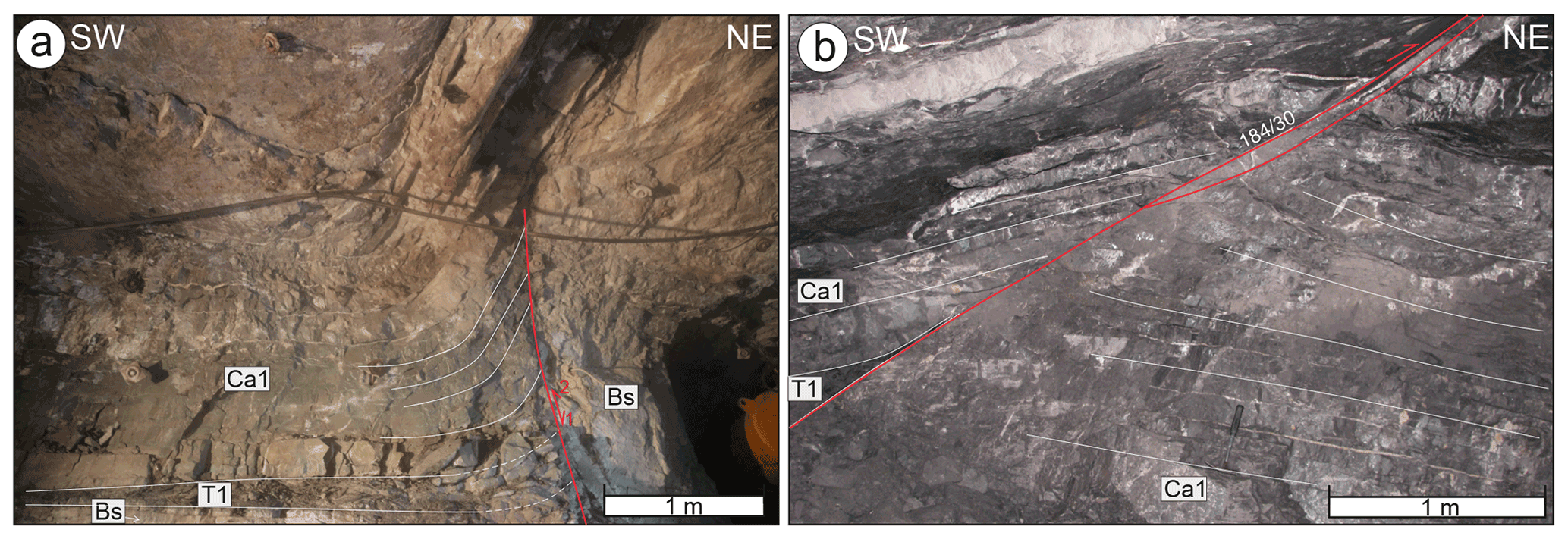
Figure 5Examples of tectonic structures observed on gallery walls in copper and silver mines on the Fore-Sudetic Homocline at the base Zechstein (upper Permian) ore-bearing formation at the contact with the Rotliegend (lower Permian) strata (location in Fig. 2). (a) Inverted steep fault, originally normal. The inversion caused fault drag of Ca1 Zechstein Limestone. (b) Thrust fault in carbonate rock (orientation recorded as dip direction/dip angle). Abbreviations: Bs – Weissliegend Sandstone (lower Permian); T1 – Kupferschiefer shale (upper Permian); Ca1 – Zechstein Limestone (upper Permian).
The southwestern margin of the Fore-Sudetic Homocline is the only area in the scope of interest of this paper, in which, due to the presence of rock salt in the Zechstein strata, the formation of Late Cretaceous–early Palaeogene structures may have been locally affected by salt tectonics.
4.2 The Fore-Sudetic Block
At the base Cenozoic level, the Fore-Sudetic Block (Figs. 2 and 3) exposes Variscan basement rocks of various metamorphic grades, varying in age from the Neoproterozoic to probable Devonian (Pożaryski, 1979; Kotański, 1997; Cwojdziński and Żelaźniewicz, 1995; Cymerman, 2010), and variable igneous plutonic rocks, mostly representing elements of a basic to ultrabasic Silurian/Early Devonian ophiolitic suite and Carboniferous to early Permian granitoids (e.g. Mazur et al., 2006, 2007; Kroner et al., 2008). As the Fore-Sudetic Block is (except at its easternmost and westernmost peripheries) devoid of Permo-Mesozoic deposits and its crystalline basement is eroded deeper than that on the mountainous Sudetic Block, an idea was conceived long ago (Cloos, 1922; Teisseyre, 1957) that the former block had been uplifted with respect to the present-day Sudety Mountains (Sudetic Block) across the Sudetic Boundary Fault, following the Late Cretaceous–early Palaeogene inversion. This situation was subsequently reversed in the late Miocene, when the Sudety Mountains were uplifted, whereas the Fore-Sudetic Block was downthrown simultaneously with the formation of the Carpathian–Alpine forebulge (e.g. Żelaźniewicz et al., 2011). The relatively small extent of the Permo-Mesozoic sedimentary cover on the Fore-Sudetic Block hampers direct recognition of the effects of the Late Cretaceous–early Palaeogene tectonism on the block. Nevertheless, these can be partly assessed thanks to the presence of the so-called Żary Pericline (Fig. 2) in the geological map intersection pattern. In map view, this pericline consists in the enveloping of the NW-projecting basement “peninsula” of the Fore-Sudetic Block by the Permo-Triassic outcrop zone, which continues to the southwest from the Fore-Sudetic Homocline. This basement–cover intersection pattern illustrates the likely up-warping (updoming) effect of the Late Cretaceous–early Palaeogene compression, which seems to have undulated the roof surface of the crystalline basement, producing a very gentle NW–SE-trending antiform. This antiform seems to be analogous to the large, gentle synform that occurs to the south of it and is observable on seismic profiles – in the floor of the North Sudetic Synclinorium (see below). The uplift related to the formation of the antiform in question must have been one of the important factors leading to the erosion of the original Permo-Mesozoic cover over the largest part of the Fore-Sudetic Block.
4.3 The North Sudetic Synclinorium
The North Sudetic Synclinorium (Figs. 2, 3 and 6) is a fault-bounded, NW–SE-elongated tectonic structure, ca. 60 km long and up to 24 km wide (Beyer, 1939; Oberc, 1972, 1977; Solecki, 1994; Kiersnowski in McCann et al., 2008a; Żelaźniewicz and Aleksandrowski, 2008; Żelaźniewicz et al., 2011). It is filled with post-Variscan, end Carboniferous–Permian–Triassic and Upper Cretaceous (Cenomanian to Coniacian) continental and shallow marine sedimentary rocks, including also a lower Permian volcanic member (e.g. Milewicz, 1997; Śliwiński et al., 2003; Chrząstek and Wojewoda, 2011). The succession overlies a subsided top surface of the Variscan epi-metamorphic basement, termed the Kaczawa Slate Belt in this region (e.g. Aleksandrowski and Mazur, 2002; Mazur et al., 2006; Żelaźniewicz and Aleksandrowski, 2008). The synclinorium acquired its geometry due to the Santonian–early Campanian to late Maastrichtian–Paleocene (Walaszczyk in Voigt et al., 2008) tectonism. The North Sudetic Synclinorium in its western and central parts defines, in general, a single synclinal structure, while at its eastern and southern extremities it splits into several NW–SE-elongated second-order synclinal elements, grabens and half-grabens, some of them separated by basement horsts (Figs. 2, 3, 6 and 7; Beyer, 1939; Śliwiński et al., 2003).
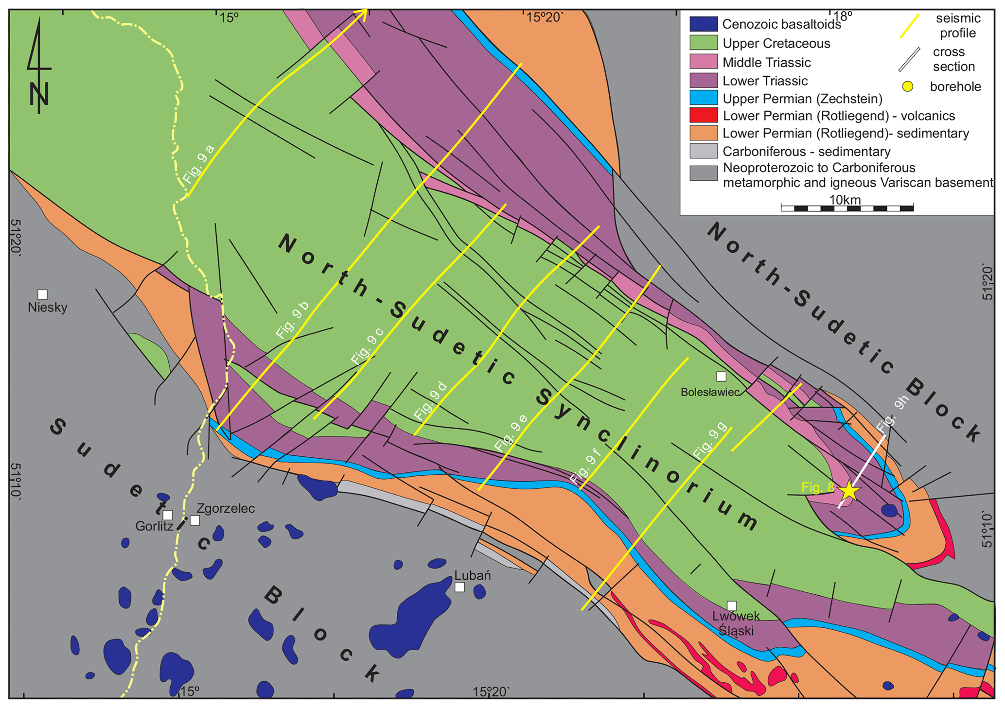
Figure 6Geological map (without Cenozoic) of the North Sudetic Synclinorium (based on Bałazińska and Bossowski, 1979; Solecki, 1994; Krentz et al., 2000; Cymerman, 2010), showing locations of the interpreted seismic profiles. For full-length location of the seismic profile of Fig. 9a, see Fig. 2.
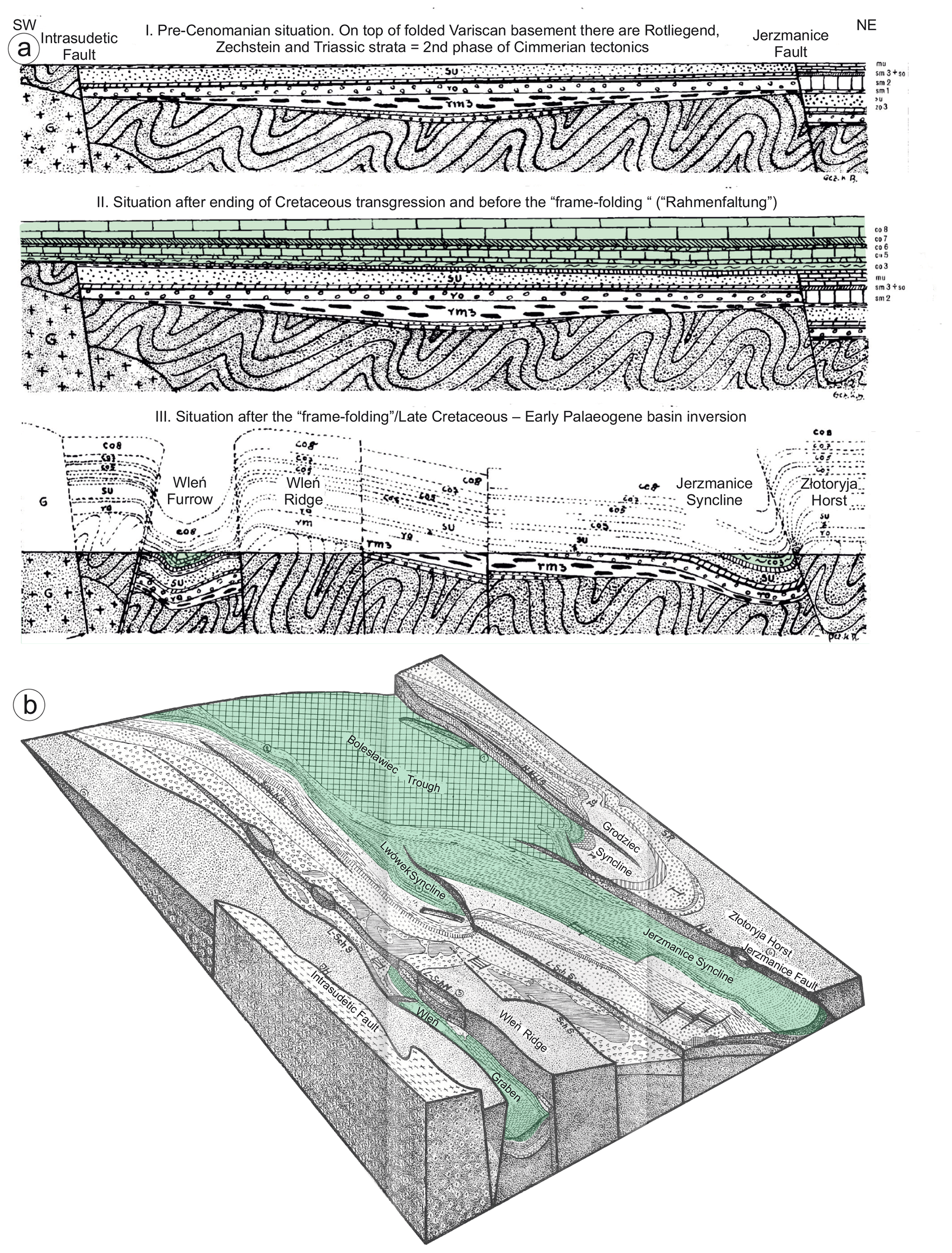
Figure 7The interpretation of Kurt Beyer (1939) of the “young Saxonian” tectonics in the North Sudetic Synclinorium (Basin). (a) Main tectonic deformation stages in the North Sudetic Basin. (b) Block-diagram showing simple open structure of the western part of the North Sudetic Synclinorium (Bolesławiec Trough) and complex pattern of blocks and synclinal grabens (Jerzmanice Syncline and Wleń Trough) in its eastern part (compare Figs. 2 and 6).
The late Mesozoic–early Cenozoic compressional deformation affected both the crystalline basement and post-Variscan cover. The cover must have once been relatively thick and must have extended over much wider areas of the Sudetic area than it does today (compare e.g. Migoń and Danišik, 2012; Sobczyk et al., 2015, 2020). It was subsequently eroded from the most uplifted areas but preserved in places where the basement–cover interface had undergone compression-driven down-warping. According to Beyer (1939), this compression in the North Sudetic Synclinorium brought about inversion of some of the earlier normal faults, which were then transformed into reverse ones (Fig. 7a). The Variscan basement at the upthrown sides of the inverted faults was believed by this author to have acted like rigid jaws of a vice, which horizontally squeezed the Permo-Mesozoic succession in the process of a “frame-controlled folding”(German Rahmenfaltung, Fig. 7a and b).
The structural geometry of the Late Cretaceous–early Palaeogene folds and related thrusts in the North Sudetic Synclinorium has been known so far mostly from geological map intersection patterns combined with drilling results (Beyer, 1939; Oberc, 1972, 1977; Leśniak, 1979; Solecki, 1986, 1994; Cymerman, 1998) and from supposed smaller-scale analogues occurring in active quarries (Fig. 8). The seismic data acquired in 1976–1980 made it possible to better constrain the structure of the post-Variscan cover, which was attempted by Bałazinska and Bossowski (1979; their Fig. 3), who assumed a dominance of nearly vertical faults.

Figure 8Folds in Muschelkalk in a quarry at Raciborowice (location in Fig. 6; photo in a – courtesy of Andrzej Solecki).
A much better insight into the geometry and structural style of the deformed Permo-Mesozoic succession was recently enabled by the reprocessing of the same legacy seismic data (Głuszyński and Smajdor, 2020). The structural interpretation results of these data are presented on seismic sections in Fig. 9. The sections depict the along-strike changing geometry of the Permo-Mesozoic succession of the North Sudetic Synclinorium. This geometry, in general, seems to have resulted from gentle buckle downfolding of the basement–cover interface, producing a single syncline, up to ca. 20 km wide, in the Permo-Mesozoic strata. The syncline is locally complicated by reverse faults (or their clusters), cutting across the Cretaceous, Triassic and Zechstein strata and hard to follow in the Rotliegend clastics and volcanics, though in some cases probably penetrating the epi-metamorphic basement while shallowing their dips. The reverse faults are often related to folds, some of them likely having been initiated as fault-propagation folds. In places, decoupling or decollement phenomena occur along weak, clayey horizons in the Zechstein and Muschelkalk strata affected by local thrusting, accompanied by spectacular but rather infrequent zones, where meso-scale detachment folds have developed (Fig. 8), apparently due to locally increased horizontal shortening in the footwall of steep reverse faults (Fig. 9g).

Figure 9Interpreted seismic profiles from the North Sudetic Synclinorium (location in Fig. 6). Explanations in the text.
The down-warping of the metamorphic basement below the Permo-Mesozoic cover may have facilitated the development of local low-angle thrusts in the basement (not visible in Fig. 9), where some of the thrusts affecting the Permo-Mesozoic are likely rooted. The Rahmenfaltung at the synclinorium edges (Fig. 7), invoked by Beyer (1939) and understood as upthrowing the relatively rigid metamorphic basement on reverse (inverted?) faults, may have also had its effect on the deformation process through exerting a horizontal-component tectonic force on the adjacent horizontal sedimentary strata. The local folds in the synclinorium interpreted from both the reprocessed seismic sections and from map intersection patterns show, in general, near-parallel geometry and shallow WNW-plunging axes (Solecki, 1986, 1994, 2011). Our analysis of the reprocessed seismic profiles made possible a subsurface mapping of a number of high-angle fault zones. They are, as a rule, trending NW–SE and often continue over distances of tens of kilometres (up to at least 40 km). Other identified major faults represent low-angle thrusts, continuing into the Variscan basement. The polarity of the local thrusts in the Permo-Mesozoic succession of the North Sudetic Synclinorium is bimodal and directed both to the NE and SW. This seems typical of folding affecting a detached succession (the Permo-Mesozoic sedimentary rocks detached from the underlying low-grade metamorphic rocks). The interpreted fault zones cut across the Permo-Mesozoic strata from the Zechstein at the bottom to the Upper Cretaceous at the top, which confirms their activity continued until at least the Late Cretaceous. On neither of the seismic profiles studied by us were any structures modified by salt tectonics identified, in spite of a single rock salt intercalation in boreholes relatively close the profile shown in Fig. 9a. Our structural analysis of the reprocessed seismics makes it possible to reinterpret the hitherto widely held concept of the internal structure for the North Sudetic Synclinorium that assumed the dominance of high-angle fault block tectonics (e.g. Milewicz, 1968; Bałazinska and Bossowski, 1979), although Solecki (1986, 1994) already postulated earlier that the main factor controlling the formation of the North Sudetic Synclinorium might have been a compressive inversion of hypothetical normal listric faults in the basement. In our opinion, effects of compressional down-warping of the top basement surface due to buckling of the basement–cover interface are of primary significance in this structure and those related to both high-angle and low-angle thrust faulting and to local detachment folding (Fig. 8) affecting the Permo-Mesozoic cover are of lesser significance.
A recent mapping and structural study by Kowalski (2021) of one of the already mentioned second-order synclinal or graben elements branching off from the SE rim of the North Sudetic Synclinorium, the Wleń Graben (Figs. 2 and 7) offers an opportunity to have a closer look at another example of a Late Cretaceous–early Palaeogene macro-scale tectonic structure in the NW part of the Sudetes. The Wleń Graben is a narrow structure, ca. 17.5 km long and up to 3.5 km wide, downthrown into the low-grade metamorphics of the Kaczawa Slate Belt, filled with Permian, Triassic and Upper Cretaceous (up to lower Coniacian) mostly sedimentary, shallow marine or continental deposits and bounded by steep, NW–SE-oriented normal and reverse faults (Fig. 10; Kowalski, 2021). The graben was earlier studied by Gorczyca-Skała (1977) and discussed by Solecki (1994, 2011), who stressed the particular significance of NNE–SSW- to NE–SW-directed compression in its formation. Kowalski (2021) advocates a multistage evolution of the graben, from Late Cretaceous times (post-Santonian?) onwards, including the first, extensional stage of its formation with active NW–SE-striking normal faults, followed by a compressional event of “probably latest Cretaceous to early Palaeogene(?)” age, re-activating and inverting the latter discontinuities and producing new reverse faults and overthrusts, particularly in the central and southern parts of the graben. This was postdated by minor sinistral displacements of the graben fragments along cross-cutting faults of NE–SE trend, and the evolution is believed by this author to have ended with an extensional episode of limited significance, presumably already during the mid- to late Cenozoic.
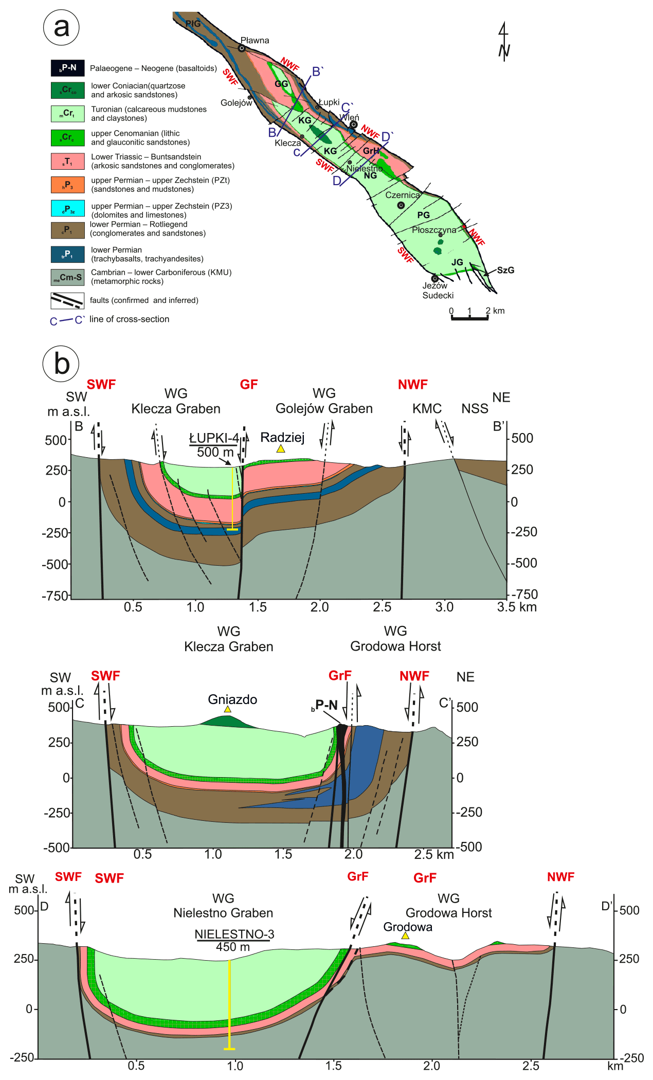
Figure 10Simplified geological map and three selected cross-sections of the Wleń Graben according to Kowalski (2021).
The cross-sections of the Wleń Graben elaborated by Kowalski (2021) on the basis on his mapping fieldwork and scarce borehole data (Fig. 10) show a rather regular syncline, only slightly modified by the graben's boundary faults and locally complicated by faults striking obliquely to the syncline's axis. The metamorphic basement top is depicted as concordantly adherent to the overlying, synclinally bent base Rotliegend surface. The concordant folding of the basement and cover, together with the above-mentioned apparent lack of a dip-slip displacement on the boundary faults of the Wleń Graben, suggests that the “graben's” origin may instead have been due to downfolding (buckling) rather than downthrowing on reverse faults. The cited author (Kowalski, 2021) suggests a seismic survey to be made in order to better understand the structural geometry of the graben.
4.4 The Intra-Sudetic Synclinorium
In addition to the North Sudetic Synclinorium, the Intra-Sudetic Synclinorium is another extensive Late Cretaceous–early Palaeogene tectonic structure of NW–SE trend in the Sudetes (Figs. 2, 3 and 11). It has a comparable, though somewhat larger, size of ca. 80 km in length and up to 30 km in width. It, similarly, affects the post-Variscan continental to shallow marine Permo-Mesozoic succession, which represents the upper structural level of the Intra-Sudetic Synclinorium (Żelaźniewicz and Aleksandrowski, 2008; Żelaźniewicz et al., 2011), deposited on top of a thick succession of intramontane Carboniferous syn- to late-orogenic clastics deformed by Variscan tectonism, corresponding to the lower structural level of the Intra-Sudetic Synclinorium (see also Nemec et al., 1982; Dziedzic and Teisseyre, 1990; Bossowski et al., 1995; McCann, 2008b). The Carboniferous deposits of the Intra-Sudetic Synclinorium rest on the Variscan-deformed, mostly crystalline basement of the Sudetic Block. To the SE, the axial zone of the Intra-Sudetic Synclinorium, composed of Upper Cretaceous deposits, merges with the Upper Nysa–Králiky Graben (Figs. 2 and 11). Another similarity of the Intra-Sudetic to the North Sudetic Synclinorium is its generally simple, open structure of a single syncline in its northwestern and central parts, which is replaced by a number of synclinal grabens separated by basement horsts on its eastern flank (Figs. 2 and 11). Some of the synclinal grabens are bounded by reverse faults.
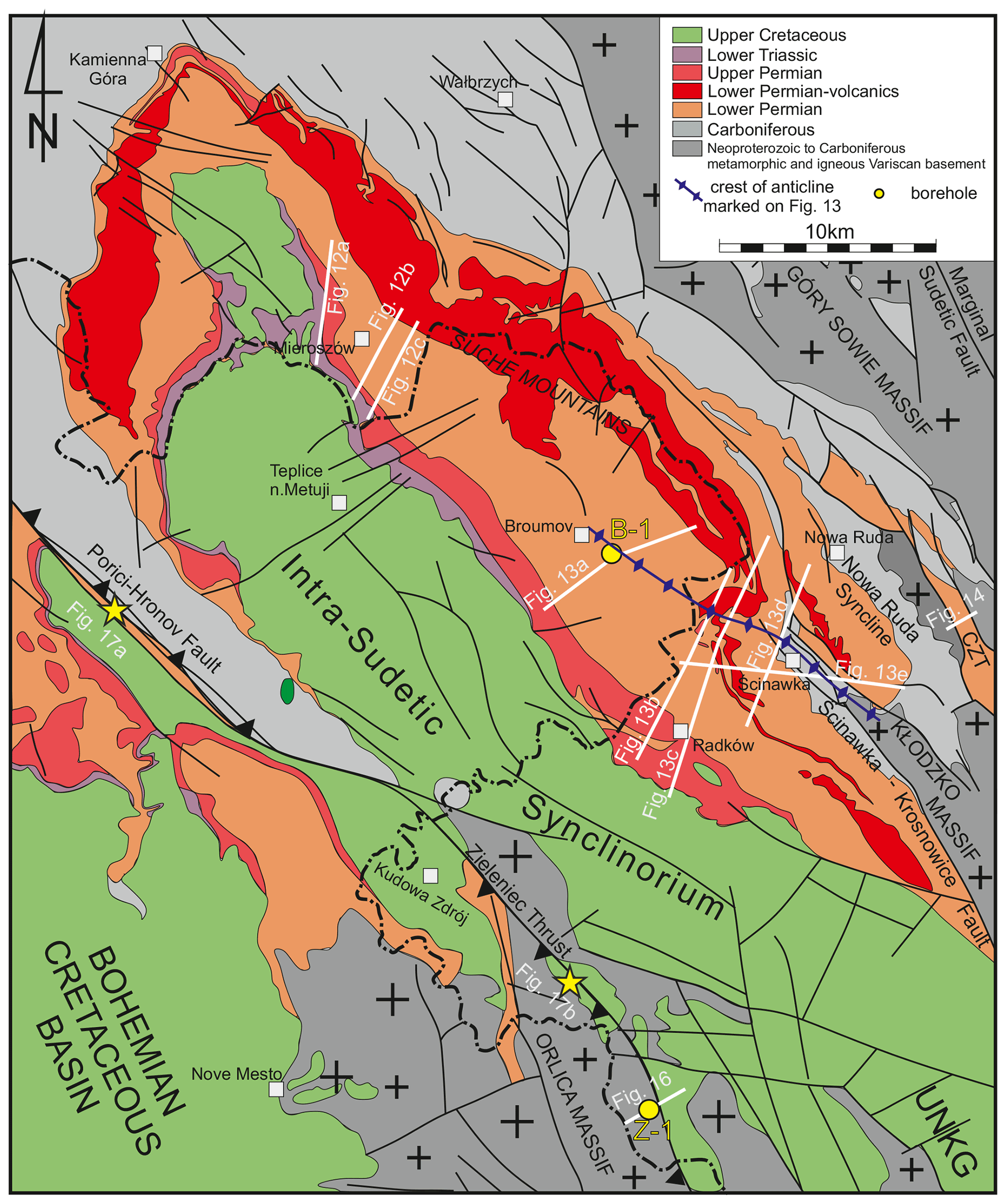
Figure 11Geological map of the Intra-Sudetic Synclinorium (based on Grocholski and Augustyniak, 1971; Bossowski and Bałazińska, 1982; Bossowski and Ihnatowicz, 2006; Cymerman, 2010). Location of the interpreted seismic profiles and described localities is shown. CZT – Czerwieńczyce Trough (reverse graben); UNKG – Upper Nysa - Králiky Graben.
The Late Cretaceous to early Palaeogene tectonic structures of the Intra-Sudetic Synclinorium imaged by reprocessed seismic data can be only studied in the NE limb of the synclinorium, located between Mieroszów in the NW and Ścinawka in the SE. In that area it is the Permian rocks that are exposed at the surface, while the Cretaceous succession of the Intra-Sudetic Synclinorium axial zone occurs to the SW and has not been imaged by seismic data. The seismic profiles (location in Fig. 11) are mostly trending SW–NE, i.e. roughly perpendicular to the synclinorium's axis. They are consecutively presented, from NW to SE, in Figs. 12 and 13, in order to illustrate in a systematic way the tectonic structures affecting the Permian and Carboniferous strata.
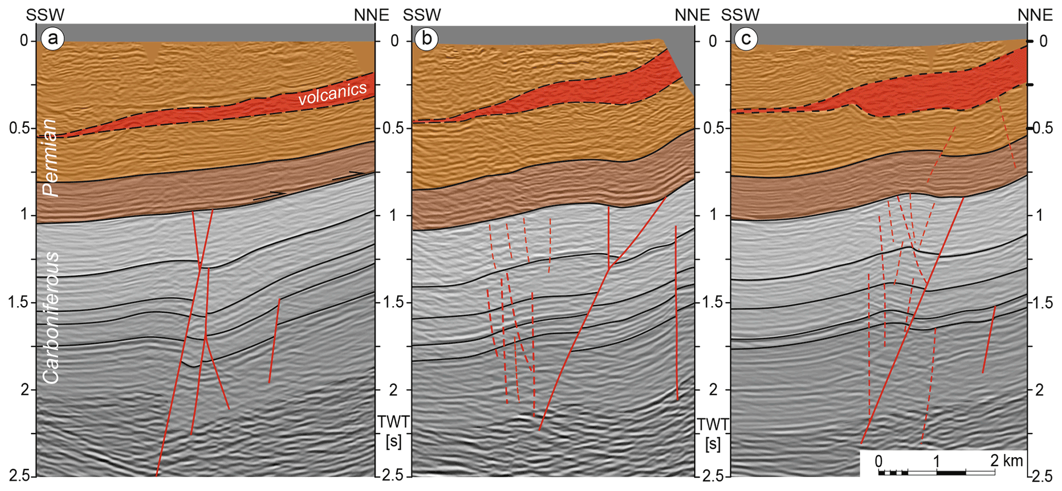
Figure 12Seismic profiles from the vicinity of Mieroszów arranged successively along-strike of the structures from NW to SE, showing probable effects of Late Cretaceous–early Palaeogene reactivation of originally Carboniferous faults. The Permian volcanic member (in red) continues to the NNE to outcrop massively in the nearby Suche Mountains. Location in Fig. 11. The faults in (a) do not show effects of post-Carboniferous reactivation, but further to SE the motion on faults resulted in very gentle folding of the overlying Permian strata in (b) and (c).
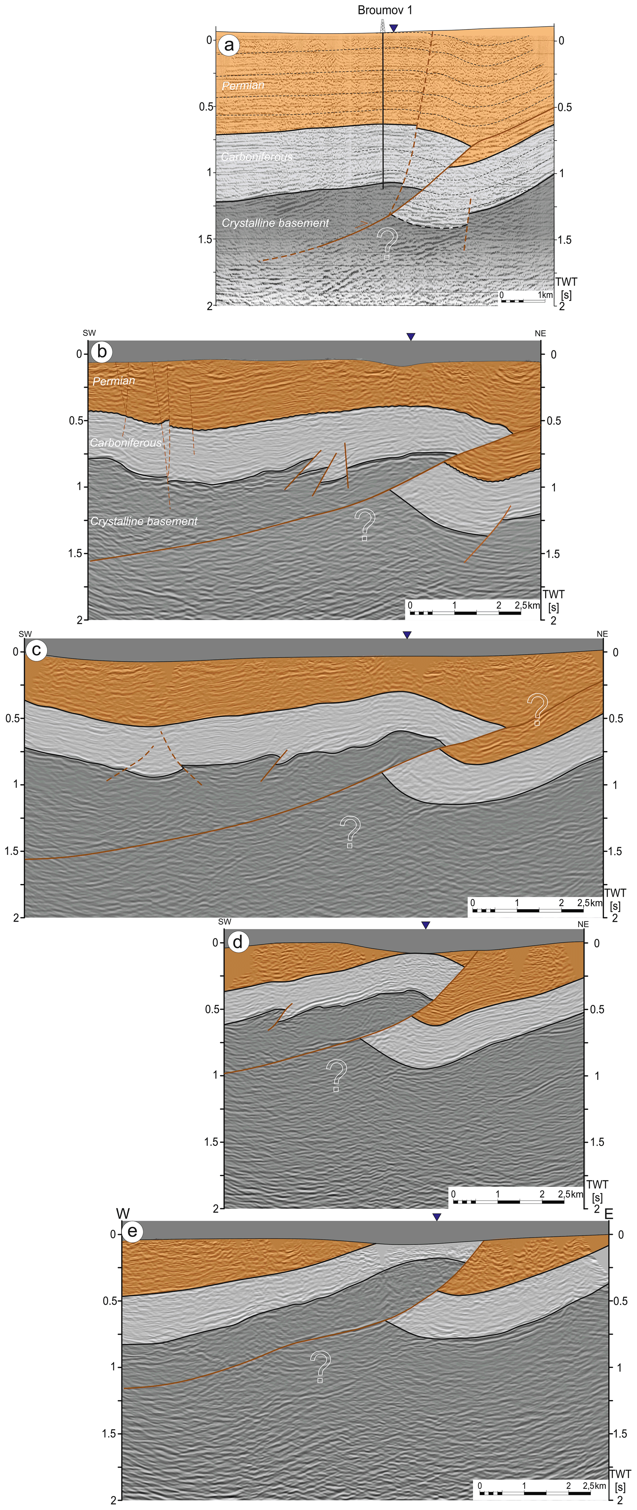
Figure 13Seismic profiles from the vicinity of Broumov (paper print version – Brada et al., 1982) (a) and from the vicinity of Radków, all arranged consecutively from NW to SE (b–e). Location in Fig. 11. The section in (a) shows that the Broumov well was drilled in the hanging wall of a thrust fault, and, hence, the Carboniferous in the neighbourhood may occur deeper than found in the well. The thrust continues to the NE parallel to the bedding – most probably as a decollement or detachment along the lower Permian Anthracosia Shale member.
In the NW part of the area covered by seismic data (Figs. 11 and 12), three consecutive profiles show a group of planar faults in Carboniferous clastics, which do not continue upwards into the Permian, although in some profiles (Fig. 12b and c) these faults manifest themselves also in the Permian strata as gentle folds above the faults. These folds are geometrically entirely consistent with fault-related folds in the Carboniferous. The most likely interpretation of this case seems to be a post-early Permian reverse-slip activity of faults in the Carboniferous succession, associated with gentle folding that locally affected also the overlying Permian strata, though in places the displacement on them entirely ceases still at a level below the Permian (Fig. 12a). The fault zone in the Carboniferous succession can be followed on seismic profiles over a distance of 7 km along-strike, but probably continues further on both to the NW and SE beyond the seismically explored area.
Further to the SE, near Broumov in Czechia (Figs. 11 and 13a), a low-angle, NE-verging thrust zone (which may represent a more developed continuation of the fault zone from Fig. 12) rooted in the crystalline basement produces a reverse-slip displacement of the Carboniferous strata by at least 2 km, associated with the formation of fault-bend folds. The thrust seems to continue to the NE as a decollement within the Permian strata, overlain by an anticline–syncline pair, which can be recognised in the surficial geological map outcrop pattern.
Moving further to the SE along the NE flank of the Intra-Sudetic Synclinorium axial zone, in the area of Radków, on the successive seismic profiles (Fig. 13b–e) one can follow along-strike geometrical changes in a conspicuous low-angle, NE-verging thrust fault, responsible for up to 2.5 km of displacement of the crystalline basement and the overlying Carboniferous and Permian strata over their footwall. Similar to the case at Broumov, the overthrust is related to an anticline–syncline pair of fault-bend or fault-propagation(?)folds.
The conspicuous thrust fault identified at depth in the area of Radków–Ścinawka (Fig. 13b–e) and – most probably – continuing into the vicinity of Broumov (Fig. 13a) seems to correspond to the major NW–SE-trending Ścinawka–Krosnowice Fault (Fig. 11) exposed at the surface. The latter fault has been, however, so far consistently interpreted as a NE-throwing normal (Grocholski and Augustyniak, 1971) or vertical fault (Bossowski and Ihnatowicz, 2006). Therefore, our interpretation of the reprocessed seismic data implies an important change in understanding the geometry and kinematics of this well-known mapped fault, so far regarded as a steep fracture at least in its NW, Ścinawka segment as a low-angle Late Cretaceous–early Palaeogene thrust. In the light of their geological context, there can be little doubt about the timing of the tectonic structures identified in the seismic profiles. Our interpretation is corroborated by their occurrence near the axial zone of the Intra-Sudetic Synclinorium, characterised by thick preserved Upper Cretaceous deposits. It is also confirmed by the southeastward surficial extension of the Ścinawka–Krosnowice Fault, which at its Krosnowice segment defines a tectonic boundary between the Permo-Mesozoic succession of the Intra-Sudetic Basin and Nysa–Králiky Graben on one side and the Śnieżnik–Krowiarki crystalline massif on the other side.
An interesting Late Cretaceous–early Palaeogene structure at the NE periphery of the Intra-Sudetic Synclinorium is the NW–SE-trending Czerwieńczyce Reverse Graben (Figs. 11 and 14). According to Oberc (1972, 1977), it is bounded by high-angle reverse faults (and, hence, we apply to it the term “reverse graben”) and filled with lower Permian Rotliegend and Upper Carboniferous sedimentary rocks. On approaching the graben's boundary faults, the strata are strongly dragged upwards, which renders a synclinal geometry to the graben's fill. This “synclinal” structural characteristic of the Czerwieńczyce Reverse Graben – if correct, being based on surficial geological mapping and involving much extrapolation at depth – is, nevertheless, quite symptomatic of a number of Sudetic grabens, and to some degree it resembles cross-sections of, e.g., the Wleń Graben by Kowalski (2021; Fig. 10) and – still more – by Gorczyca-Skała (1977, not reproduced here) or of the Upper Nysa–Králiky Graben by, e.g., Jerzykiewicz (1970) and Don and Gotowała (2008), partly with reverse boundary faults.
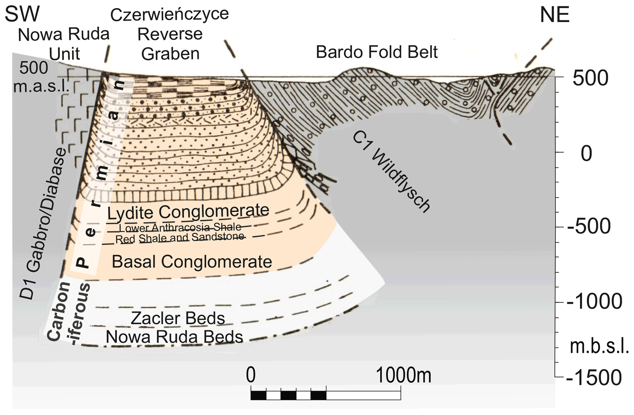
Figure 14Geological cross-section of the Czerwieńczyce Reverse Graben after Oberc (1972). Location in Figs. 2 and 11.
4.5 The Upper Nysa–Králiky Graben
The Upper Nysa–Králiky Graben (Figs. 2 and 15) is a distinctive tectonic and topographic fault-bounded feature of approximate N–S trend, ca. 45 km long and from 3 to 12 km wide, merging to the north with the Intra-Sudetic Synclinorium. It is composed of shallow marine sedimentary rocks, including a time span from the early Cenomanian through to the Turonian to Coniacian and Santonian (e.g. Don and Don, 1960; Jerzykiewicz, 1970, 1971; Radwański, 1975; Don and Gotowała, 2008; Badura and Rauch, 2014), downthrown with respect to the medium-grade metamorphic rocks of the Orlica-Śnieżnik Massif of the graben's shoulders. Most of the earlier authors (except Jerzykiewicz, 1970, 1971; Radwański, 1975 and Oberc, 1972) explained the origin of the Upper Nysa–Králiky Graben as a result of a Late Cretaceous rifting, subsequently modified by Cenozoic subsidence (e.g. Don and Don, 1960; Don, 1996; Wojewoda, 1997; Don and Gotowała, 2008). The early rifting was inferred to have occurred on stratigraphic and sedimentological premises – not convincing in our opinion, as they ignored the striking resemblance of the lower parts of the Cretaceous stratigraphic columns from within the graben and from the Góry Stołowe (Table Mountains) on one of its shoulders (Don and Gotowała, 2008) and the probable absence of fault-controlled coarse-grained deposits along the graben's edges. The assumed rifting was explained by most authors as being due to compression or, by contrast, as due to extension-driven updoming of the Orlica-Śnieżnik Massif during the Cretaceous or by pull-apart graben formation due to strike-slip displacements on NW–SE-trending structural discontinuities in the crystalline basement. In contrast, we interpret the mostly N–S-trending Upper Nysa–Králiky Graben as representing a late Cenozoic feature, whose boundary faults cut out and downthrown a strip of the Cretaceous (Cenomanian, Turonian, Coniacian through to Santonian) shallow marine succession previously much more widespread over the area. The uniqueness of the Cretaceous deposits in the Upper Nysa–Králiky Graben consists only in the preservation of the thick Coniacian to Santonian succession in it, absent from the uplifted areas nearby (Don and Gotowała, 2008), from where it must have been eroded. The Upper Nysa–Králiky Graben is imposed on and cuts across earlier, Late Cretaceous–early Palaeogene tectonic structures of consistent NW–SE strike, which are in most places oblique to and cross-cut by the graben's boundaries (Fig. 15). These structures are represented by differentially dip-slip-displaced fault blocks, often bounded by reverse faults, and by gentle folds (Badura and Rauch, 2014; Don and Gotowała, 2008).
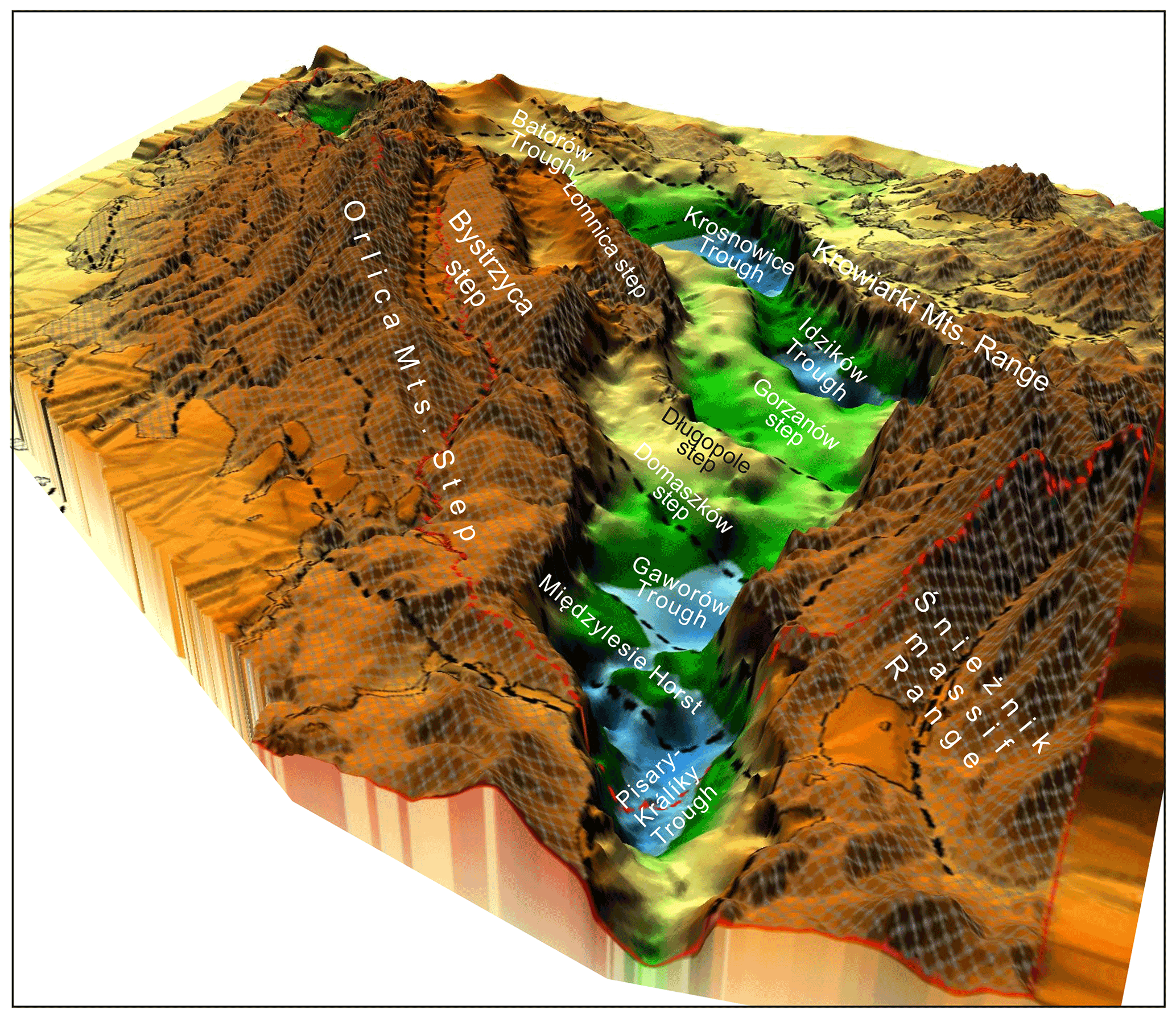
Figure 15Perspective view towards the north onto the base Cretaceous relief (known from boreholes) in the Upper Nysa–Králiky Graben (from Badura and Rauch, 2014). The oblique-striking troughs, steps and horsts reflect NW–SE-trending Late Cretaceous–early Palaeogene structural grain defined by inverted blocks underlying the Cretaceous graben floor and folds in its fill (removed from the picture), once continuing laterally, before the graben formation in Miocene times. Location given in Fig. 2.
Locally, shallow-dipping thrust faults, most probably of Late Cretaceous–early Palaeogene, age were mapped, drilled or directly observed in outcrops within or in the direct vicinity of the Upper Nysa–Králiky Graben. A relatively extensive, at least 25 km long, NW–SE-trending trace of the Zieleniec Thrust Fault (Fig. 11) was mapped by Cymerman (1990) and extrapolated on maps by other authors within the SW flank of the Upper Nysa–Králiky Graben. On this ca. 40–50∘ SW-dipping fault (Fig. 16) a 500 Ma orthogneiss mass of the Góry Bystrzyckie Mountains was overthrust, displaced by at least 5300 m toward the NE (Cymerman, 1990) and emplaced on top of the gently dipping Turonian clastics, equivalent to those from the lower part of the Upper Nysa–Králiky Graben fill and resting on analogous orthogneiss basement. Cymerman (1990) interpreted this thrust as produced by late Alpine (Miocene) compression. The Zieleniec Thrust was later confirmed by drilling, as reported by Kozdrój (2014), who interpreted the thrusting as the result of a Cenozoic gigantic, gravity-driven landslide, at the same time referring to the inversion of an original normal fault into a reverse one. One of the most important arguments for this interpretation was finding a subhorizontal position of the Cretaceous–gneiss contact in the drill core. In our opinion, taking into account the significant extent of the Zieleniec Thrust Fault and its involvement in the major NW–SE-trending fault system (Fig. 11), termed the South Sudetic Shear Zone by Wojewoda (e.g. in Wojewoda and Kowalski, 2016), which also comprises the major Pořiči–Hronov Fault (see below), there cannot be much doubt that the Zieleniec Thrust represents a Late Cretaceous–early Palaeogene structure similar to that of the Łużyce Thrust (see below), though of an opposite vergence.
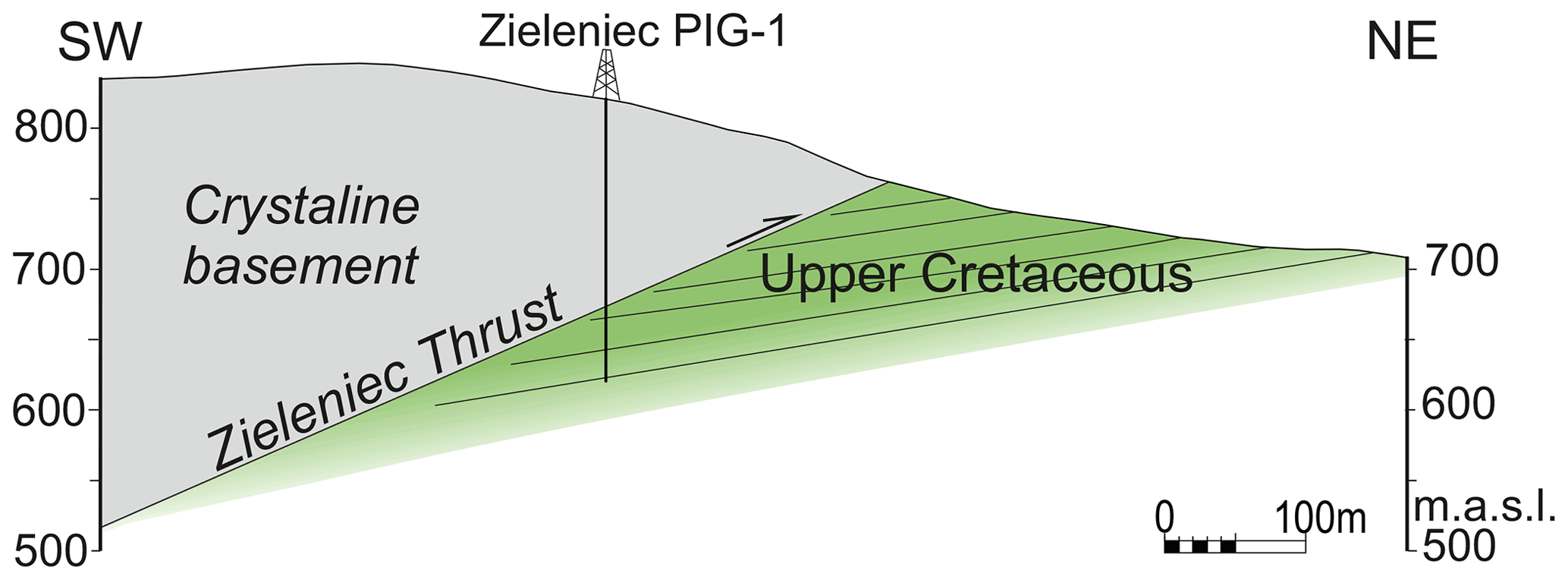
Figure 16Schematic section across the Zieleniec Thrust (based on data from Cymerman, 1990, and Kozdrój, 2014). Location in Figs. 2 and 11.
To the NW the Zieleniec Thrust merges with the southeastern extension of the Pořiči–Hronov major fault system (Fig. 11), partly representing the SW boundary to the Intra-Sudetic Synclinorium. It was active, as well, in the Late Cretaceous–early Palaeogene as a high-angle reverse fault of complex structure but of an opposite, SW, polarity (Prouza et al., 2014), which – according to some authors – was combined with a strike-slip component of motion (Wojewoda, 2007, 2009; Nováková, 2014) (Fig. 17a). To the SE, the Pořiči–Hronov Fault continues into the Duszniki–Gorzanów (or Krosnowice) Fault, at the northern end of the Upper Nysa–Králiky Graben (compare Petrascheck, 1933; Prouza et al., 2014).
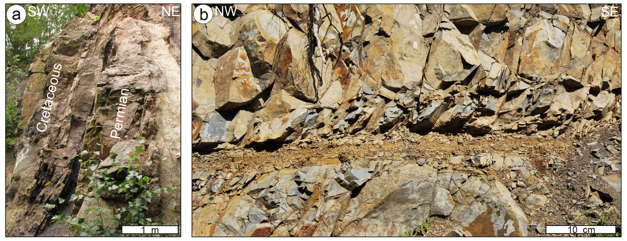
Figure 17Examples of outcrop-scale brittle structures related to major faults at the SW boundary of the Intra-Sudetic Synclinorium. (a) The Pořiči–Hronov Fault, interpreted as a high-angle reverse structure, near the village of Malé Svatoňovice: tectonic contact between nearly vertically dipping Upper Cretaceous sandstones in the SW and the Permian sandstone in the NE. (b) Shallow NW-dipping detachment along the bedding of middle Turonian mudstones and calcareous claystones in a road cut near the village of Lewin Kłodzki, probably related to the NW continuation of the Zieleniec Thrust. Location in Figs. 2 and 11.
A presumable NW extension of the Zieleniec Thrust (Figs. 11 and 17b) was described directly in a ca. 1 km long chain of outcrops along a road cut between Duszniki Zdrój and Lewin Kłodzki near the pass of Polskie Wrota on the same SW flank of the Upper Nysa–Králiky Graben (Wojewoda et al., 2010; Aleksandrowski and Wojewoda, 2010). A ca. 20∘ NW-dipping detachment can be seen to occur there roughly along the bedding in middle Turonian mudstones and calcareous claystone. On a closer inspection, the detachment was found to represent a shear zone, attaining 7 to 25 cm in thickness and composed of interconnected, kinematically linked surfaces, confined between two distinct boundaries of mostly intact rock (Fig. 17b). The shear zone shows internal flaser bedding and is composed of cataclastic flow products of host-rock composition, which coexist with crush breccia and calcite veins. Based on evidence from the orientation of the accompanying joints, the detachment was originally interpreted as SE-verging and probably genetically related to a supposed strike slip motion on the nearby major NW–SE-trending Duszniki–Gorzanów Fault, being a SE continuation of the Pořiči–Hronov Fault system (compare Petrascheck, 1933; Prouza et al., 2014). It seems likely, however, that the joints can represent the youngest, Miocene, deformation and episode of motion on the detachment in question, whereas its very origin and principal displacement were related to the Zieleniec Thrust.
4.6 The southwestern margin of the Sudetes: transition to the North Bohemian Cretaceous Basin
The NW segment of the Sudetic Block, represented by the Karkonosze–Izera Massif, to the SW adjoins the North Bohemian Cretaceous Basin (Fig. 2). At its Sudetic margin, the basin is composed of deltaic to shallow marine and hemipelagic Cenomanian to Santonian clastic deposits, not exceeding 600 to 700 m in thickness, that rest subhorizontally on scarce sub-crops of Permian and Carboniferous but mostly on the crystalline Variscan basement of the Bohemian Massif (e.g. Klein and Soukup, 1966; Malkovský, 1987; Uličny et al., 2009; Wilmsen et al., 2014). The basin's interior is only little affected by the Late Cretaceous–early Palaeogene tectonism; however at its boundary with the Sudetic Block the deformation is concentrated at the spectacular and in places well-exposed Lusatian Thrust (Figs. 2 and 18a–c), which continues NW up to the vicinity of Dresden (e.g. Wagenbreth, 1967), whereas to the east it continues to the western Karkonosze Piedmont Basin area (Prouza et al., 2014). The Lusatian Thrust has been excellently described and analysed in detail by Coubal et al. (2014, 2015).
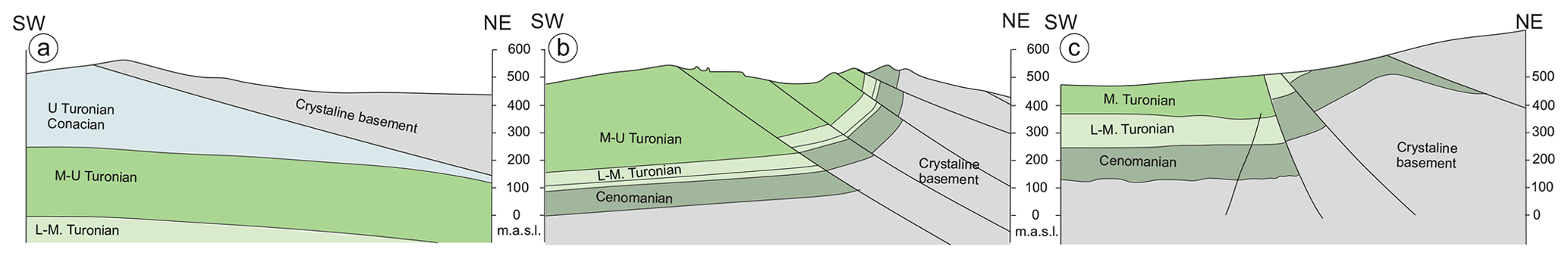
Figure 18Schematic sections across the Lusatian Thrust at three localities, showing along-strike structure changes (based on Coubal et al., 2014). Location in Fig. 2.
The Lusatian Thrust (e.g. Malkovský, 1976, 1977), similarly to other main NW–SE-trending fault zones of the Sudetic area at the Bohemian NE margin (the Intra-Sudetic Fault, the Sudetic Boundary Fault, the Odra Fault Zone), derives its origin from a major Variscan fracture, rooted deeply in the basement and likely having primary strike-slip characteristics (compare to Aleksandrowski et al., 1997). It must have been reactivated during the Late Cretaceous–early Palaeogene compressional episode and propagated into the Permo-Mesozoic cover. The Lusatian Thrust emplaces the Variscan crystalline complexes of Lusatia and of the Western Sudetes on top of the Mesozoic strata of the North Bohemian Cretaceous Basin. This fault zone reveals significant along-strike changes in the dip angle of its displacement surface, which is between low angle or subhorizontal in the northwest (Figs. 2 and 18a) through to medium-angle (Figs. 2 and 18b) and high-angle attitudes (Figs. 2 and 18c). The angle made by the displacement zone (or fault) core, apparently representing a reactivated fracture, with respect to the – supposedly generally subhorizontal – tectonic shortening direction had a serious influence on the structural style and complexity of the brittle structures that developed around the fault core and across the width of the damage zone (Coubal et al., 2014). The smaller the angle between the two, the more smoothly the displacement occurred (Fig. 18a–c). An increase in the fault plane dip angle made the displacement more difficult to be achieved, which resulted in widening a zone of damage and of fault drag and favoured splitting the displacement into several slip surfaces (Fig. 18b and c).
The regional pattern of tectonic joints over the Sudetic area or that of SW Poland can be inferred from a number of local studies on jointing, most of which were conducted decades ago. Not attempting to make a systematic review of such studies, for the needs of the brief review made in this paper, several stereograms and rose diagrams of the dominant joint sets coming from various sources (Jerzykiewicz et al., 1974; Aleksandrowski, 1976; Solecki, 2011; Selerowicz et al., 2014) and various locations in the Polish Sudetes are shown on the geological map (Fig. 19). The data come mostly from the Permo-Mesozoic strata exposed at outcrops in the both Sudetic synclinoria, in underground galleries of the deep copper mines at the Fore-Sudetic Homocline and in the Opole Cretaceous Basin (Fig. 2).

Figure 19Comparison of stereograms and rose diagrams of the dominant steep joint sets coming from several local studies (by Jerzykiewicz et al., 1974; Aleksandrowski, 1976; Solecki, 2011; Selerowicz et al., 2014) made at various locations in the Polish Sudetes. Background: the geological map of Fig. 2.
Two stereograms (Fig. 19f, g) show, additionally the jointing pattern in the Carboniferous granitic rocks of the Karkonosze Massif. From recent low-temperature geochronology studies (Migoń and Danišík, 2012; Sobczyk et al., 2015) it follows that the present-day exposure level of at least some parts of the Karkonosze pluton was still at a depth of a few kilometres at the end of Cretaceous, and hence the joints we observe recently in granites on the earth's surface may, indeed, be Late Cretaceous–Cenozoic, in respect of their initiation and opening (compare e.g. Price, 1966; Jaroszewski, 1984; Suppe, 1985; Engelder, 1985, 1987, 1993; Price and Cosgrove, 1994), similarly to the joints in the Mesozoic sedimentary rocks. We suppose that the initiation of the dominant regional tectonic joints pattern in the Sudetic rock complexes may have occurred at a depth of a few kilometres, under a significant overburden, due to the Late Cretaceous–early Palaeogene compression. The initiation involved processes of subcritical crack growth under directional stress (e.g. Atkinson, 1982; Atkinson and Meredith, 1987), leading to the formation of anisotropy defined by systematically oriented microfractures. The latter mechanical anisotropy acquired by the rocks on compression may have subsequently controlled the massive joint opening during the Cenozoic regional uplift and concomitant unloading and extension.
All the diagrams presented in Fig. 19 show most steep joints to be concentrated in two mutually perpendicular maxima, in which the joint planes are approximately parallel and perpendicular to the inferred Late Cretaceous–early Palaeogene shortening direction (compare e.g. Solecki, 1995, 2011; Nováková, 2014). As, moreover, they occur in the Permo-Mesozoic strata, a conclusion that they are genetically related to that shortening event seems plausible. We suppose that the formation of the dominant jointing pattern in the post-Variscan (but also partly in the Variscan) Sudetes and, in general, in the SW part of Poland resulted from the Late Cretaceous–early Palaeogene compressional event.
A more direct record of the Late Cretaceous–early Palaeogene compressional event is contained in the well-developed systems of silicified complementary deformation bands (compare Aydin and Johnson, 1983; Fossen et al., 2007), described by Solecki (1988, 1994, 1995, 2011) as cataclastic bands from the Buntsandstein and Coniacian sandstones of the North Sudetic Synclinorium (see also Kowalski, 2021). The bisectors of the acute angle between the best-developed two complementary sets of the deformation bands, dipping at moderate angles to the NE and SW, respectively, correspond to the maximum principal compressive stress axis during their formation and, as a rule, show a subhorizontal, NE–SW-oriented position.
In our brief review of the Late Cretaceous–early Palaeogene tectonic structures affecting the NE margin of the Bohemian Massif we have shown their common and widespread occurrence all over the region and, to some degree, shortly discussed their style and mechanisms of formation. These structures are easily recognisable in the Permo-Mesozoic post-Variscan cover, which is devoid of other, earlier formed contractional deformations, but, though undoubtedly present, they are much less obvious in the Variscan basement that was heavily tectonised before. The structures developed in the post-Variscan cover particularly those due to fault displacements – and, among them, the strike-slip-related ones – can still be difficult to separate from the structures that might have resulted from the younger, Cenozoic events.
Our structural analysis of newly reprocessed legacy seismic profiles, complemented with outcrop and drill hole data, has revealed the structural geometry and some interesting details of the tectonic structures produced by contractional deformation in the Permo-Mesozoic (partly also in the Carboniferous) strata of the two main Sudetic synclinoria. The deformation included gentle buckling of the basement–cover interface in the North Sudetic Synclinorium, with local complications of thus produced wide synclinal folds by relatively minor thrusts, often rooted in the Variscan metamorphic basement and accompanied by thrust-related folds. Locally, rather infrequent decoupling or decollement of some packages within the Permo-Mesozoic succession along weak, clayey horizons in, e.g., Triassic Muschelkalk strata was also recorded. As the low- or medium-angle thrust faults identified in the Permo-Mesozoic strata are often rooted in the top parts of the Variscan basement, particularly in the Intra-Sudetic Synclinorium, some elements of the thick-skinned style of shortening can be expected in the deep crystalline basement. It is, therefore, likely that also outside the areas covered with Permo-Mesozoic sedimentary sequences, over the crystalline basement exposure areas, some (even major) faults interpreted from surficial geological maps and outcrop relationships as vertical or high-angle structures may have at depth a geometry of low-angle thrusts. This may have important practical implications for, e.g., geothermal prospecting in the Sudetes, where the deep groundwaters in the crystalline basement circulate, almost exclusively, along structural discontinuities, such as fault zones and fracture corridors (e.g. Dowgiałło, 2002).
The Late Cretaceous–early Palaeogene compressional event seems to be also responsible for the formation of the regionally dominant tectonic joints pattern in both Permo-Mesozoic and older rocks of the Sudetic area, characterised by an orthogonal joint system with two sub-vertical sets of ca. NW–SE and NE–SW strikes, as is shown by a comparison of results from a few local studies.
The seismic data from Poland are available at the National Geological Archive, Polish Geological Institute in Warsaw, and the seismic profile from the Broumov area is available at the Czech Geological Survey Archive in Prague.
Both AG and PA wrote the text, prepared the figures and compiled the paper.
The contact author has declared that neither of the authors has any competing interests.
Publisher’s note: Copernicus Publications remains neutral with regard to jurisdictional claims in published maps and institutional affiliations.
This article is part of the special issue “Inversion tectonics – 30 years later”. It is not associated with a conference.
The consent of the Polish Oil and Gas Company (PGNiG) to publish their seismic data is gratefully acknowledged. Similarly, Janusz Badura, Aleksander Kowalski, Marta Rauch and Andrzej Solecki, together with the geological institutes of the Polish Academy of Sciences and of the University of Wrocław as well as the Polish Geological Society and the Polish Geological Institute – National Research Institute, are thanked for the permission to reproduce their illustrative materials. We also express our gratitude to Jonas Kley, Andrzej Solecki and Christoph von Hagke for their constructive and helpful reviews and, last but not least, to Piotr Krzywiec for the inspiration and encouragement to write this paper as well as for valuable editorial suggestions. Schlumberger Ltd is thanked for providing academic licenses for Petrel.
This work was supported by the Polish Geological Institute (grant no. 62.9012.2046.00.0). The reprocessing of the key reflection seismic data from the North and Intra-Sudetic Synclinoria was commissioned by the Polish Geological Institute as part of its statutory duties, financed by the National Fund of Environmental Protection and Water Management in Warsaw (grant no. 44/2017/Wn-07/FG-SM-DN/D) and performed by GK Processing Sp. z o.o. in Cracow.
This paper was edited by Piotr Krzywiec and reviewed by Jonas Kley, Andrzej Solecki, Christoph von Hagke, and one anonymous referee.
Aleksandrowski, P.: Geological mapping survey of the Karkonosze main range between Mt. Śnieżka and Mt. Skalny Stół, Unpubl. MSc thesis, University of Wrocław Archive no. WV-5200/8148, 1976 (in Polish).
Aleksandrowski, P. and Mazur, S.: Collage tectonics in the northeasternmost part of the Variscan Belt: the Sudetes, Bohemian Massif, in: Palaeozoic Amalgamation of Central Europe, vol. 201, edited by: Winchester, J. A., Pharaoh, T. C., and Verniers, J., Geological Society, Special Publications, London, 237–277, https://doi.org/10.1144/GSL.SP.2002.201.01.12, 2002.
Aleksandrowski, P. and Wojewoda, J.: Low-angle detachment related to strike-slip faulting in Late Cretaceous mudstones of the Table Mountains (SW Poland), in: 11th Czech-Polish Workshop On Recent Geodynamics of the Sudetes and Adjacent Areas, Třešť, Academy of Sciences of the Czech Republic (Institute of Rock Mechanics) and Wrocław University of Environmental Sciences (Institute of Geodesy and Geoinformatics), 4–6 November 2010, Abstracts, 30–31, https://doi.org/10.13140/2.1.2513.8882, 2010.
Aleksandrowski, P., Kryza, R., Mazur, S., and Żaba J.: Kinematic data on major Variscan fault and shear zones in the Polish Sudetes, NE Bohemian Massif, Geol. Mag., 134, 727–739, 1997.
Atkinson, B. K.: Subcritical crack growth in geological materials, J. Geophys. Res., 89, 4077–4114, 1982.
Atkinson, B. K. and Meredith, P. G: The theory of subcritical crack growth with applications to minerals and rocks, in: Fracture Mechanics of Rocks, edited by: Atkinson, B. K., Academic Press, London, 111–166, https://doi.org/10.1016/B978-0-12-066266-1.50009-0, 1987.
Aydin, A. and Johnson, A. M.: Analysis of faulting in porous sandstones, J. Struct. Geol., 5, 19–31, 1983.
Badura, J. and Rauch, M.: Tectonics of the Upper Nysa Kłodzka Graben, Geologia Sudetica, 42, 137–148, 2014.
Bałazińska, J. and Bossowski, A.: Wgłębna budowa geologiczna środkowej i zachodniej części synklinorium północnosudeckiego w świetle nowych danych [Deep geological structure of central and western parts of the North-Sudetic Synclinorium; some new data], Kwartalnik Geologiczny, 23, 309–321, 1979 (in Polish with English abstract).
Baranowski, Z., Haydukiewicz, A., Kryza, R., Lorenc, S., and Muszynski, A.: Outline of the geology of the Góry Kaczawskie (Sudetes, Poland), Neues Jahrbuch für Geologie und Paläontologie, Abhandlungen, 179, 223–257, 1990.
Beyer, K.: Die nordsudetische Rahmenfaltung, Abh. Naturforsch. Ges. Görlitz, 32, 121–172, 1939.
Bossowski, A. and Bałazińska, J.: Ewolucja tektoniczno-strukturalna synklinorium północnosudeckiego [Tectonic-structural evolution of the North-Sudetic Synclinorium], Biuletyn Instytutu Geologicznego, 341, 163–167, 1982 (in Polish).
Bossowski, A. and Ihnatowicz, A.: Atlas geologiczny Dolnośląskiego Zagłębia Węglowego [Geological atlas of the Lower Silesian coal Basin], 1:100 000, Państwowy Instytut Geologiczny, Warszawa, ISBN 83-7372-895-3, 2006.
Bossowski, A., Ihnatowicz, A., Mastalerz, K., Kurowski, L., and Nowak, G.: Lithostratigraphy and sedimentologic-paleogeographic development, Intra-Sudetic Depression, in: The Carboniferous system in Poland, edited by: Zdanowski, A. and Żakowa, H., Prace Państwowego Instytutu Geologicznego, 148, 142–147, 1995.
Brada, Z., Fejfar, M., Ibrmajer, I., Jihlavcová, R., and Petřík, A.: Study of coal-bearing formations in the Bohemian Massif – Partial report on seismic reflection survey of the Broumov promontory, Geofyzika Brno, unpublished report, Archive, Czech Geological Survey, 1982 (in Czech).
Chrząstek, A. and Wojewoda, J.: Mezozoik południowo-zachodniej Polski – synklinorium północnosudeckie [Mesozoic of SW Poland, the North Sudetic Synclinorium], in: Mezozoik i kenozoik Dolnego Śląska, edited by: Żelaźniewicz, A., Wojewoda, J., and Ciężkowski, W., Polskie Towarzystwo Geologiczne, Wrocław, 1–10, ISBN 978-83-924869-8-5, 2011 (in Polish with English abstract).
Cloos, H.: Der Gebirgsbau Schlesiens und die Stellung seiner Bodenschätze, Gebrüder Borntraeger, Berlin, 1–107, 1922.
Coubal, M., Adamovič, J., Málek, J., and Prouza, V.: Architecture of thrust faults with alongstrike variations in fault-plane dip: anatomy of the Lusatian Fault, Bohemian Massif, Journal of Geosciences, 59, 183–208, https://doi.org/10.3190/jgeosci.174, 2014.
Coubal, M., Malek, J., Adamovič, J., and Štěpančíková, P.: Late Cretaceous and Cenozoic dynamics of the Bohemian Massif inferred from the paleostress history of the Lusatian Fault Belt, J. Geodyn., 87, 26–49, https://doi.org/10.1016/j.jog.2015.02.006, 2015.
Cwojdziński, S. and Żelaźniewicz, A.: Podłoże krystaliczne bloku przedsudeckiego [Crystalline basement of the Fore-Sudetic block], in: Annales Societatis Geologorum Poloniae, Special Volume: Przewodnik 66 Zjazdu Polskiego Towarzystwa Geologicznego [Guide to excursions, 66th Annual Meeting of the Polish Geological Society], Wrocław, 21–24 September 1995, 11–28, 1995 (in Polish with English summary).
Cymerman, Z.: Młodoalpejskie nasuniecie Zieleńca w Górach Orlickich [Late-Alpine Zieleniec overthrust in the Orlickie Mts], Przegląd Geologiczny, 10, 422–427, 1990 (in Polish with English abstract).
Cymerman, Z.: Młodoalpejskie fałdy w depresji północnosudeckiej: przykłady z wapienia muszlowego z Raciborowic [Late-Alpine folds in the North-Sudetic Depression: examples from Muschelkalk at Raciborowice], Przegląd Geologiczny, 4, 348–354, 1998 (in Polish).
Cymerman, Z.: Tectonic map of the Sudetes and the Fore-Sudetic Block 1: 200 000, 2nd edn., Państwowy Instytut Geologiczny, Warszawa, ISBN 978-83-7538-653-0, 2010.
Dadlez, R., Marek, S., and Pokorski, J.: Geological map of Poland without Cainozoic deposits, 1 : 1 000 000, Państwowy Instytut Geologiczny, Warszawa, Poland, 2000.
Don, B. and Don, J.: Geneza rowu Nysy na tle badań wykonanych w okolicach Idzikowa [Notes on the origin of the Nysa Graben], Acta Geol. Pol., 10, 71–106, 1960 (in Polish).
Don, J.: The Late Cretaceous Nysa Graben: implications for Mesozoic – Cenozoic fault – block tectonics of the Sudetes, Z. Geol. Wissenschaft., 24, 317–424, 1996.
Don, J. and Gotowała, R.: Tectonic evolution of the late Cretaceous Nysa Kłodzka Graben, Sudetes, SW Poland, Geologia Sudetica, 40, 51–63, 2008.
Dowgiałło, J.: The Sudetic geothermal region of Poland, Geothermics, 31, 343–359, 2002.
Dumicz, M. and Don, J.: Analiza strukturalna monokliny przedsudeckiej w rejonie Polkowic [Structural analysis of the Fore-Sudetic Homocline in vicinities of Polkowice], Acta Universitatis Wratislaviensis 378, Prace Geologiczno-Mineralogiczne, 6, 279–297, 1977 (in Polish).
Dumicz, M. and Don, J., Próba odtworzenia następstwa zjawisk tektonicznych w osadach cechsztynu obszaru Polkowic na podstawie obserwacji drobnych struktur tektonicznych [An attempt at reconstruction of the sequence of tectonic phenomena in the Zechstein sediments at the Polkowice area on the basis of study on minor tectonic structures], in: Materiały konferencji komisji tektoniki Komitetu Nauk Geologicznych PAN: Problemy tektoniki Legnicko-Głogowskiego Okręgu Miedziowego, część II – wycieczki geologiczne, Lubin, Wydawnictwo CUPRUM, Wrocław, 22-23 March 1990, 39–45, 1990 (in Polish).
Dziedzic, K. and Teisseyre, A. K.,: The Hercynian molasse and younger deposits in the Intra-Sudetic Depression, SW Poland, Neues Jahrb. Geol. Paläont. ABH, 179, 285–305, 1990.
Engelder, T.: Loading paths to joint propagation during a tectonic cycle: an example of the Appalachian Plateau, USA, J. Struct. Geol., 7, 459–476, 1985.
Engelder, T.: Joints and shear fractures in rocks, in: Fracture Mechanics of Rocks, edited by: Atkinson, B. K., Academic Press, London, 27–69, https://doi.org/10.1016/B978-0-12-066266-1.50007-7, 1987.
Engelder, T.: Stress regimes in the lithosphere, Princeton University Press, Princeton, New Jersey, 457 pp., ISBN 0691085552, 1993.
Feist-Burkhardt, S., Götz, A., Szulc, J., Borkhataria, R., Geluk, M., Haas, J., Hornung, J., Jordan, P., Kempf, O., Michalík, J., Nawrocki, J., Reinhardt, L., Ricken, W., Röhling, H-G., Rüffer, T., Török, Á., and Zühlke, R.: Triassic, in: The Geology of Central Europe, Volume 2, Mesozoic and Cenozoic, edited by: McCann, T., Geological Society, London, 749–821, https://doi.org/10.1144/CEV2P, 2008.
Fossen, H., Schultz, R. A., Shipton, Z. K., and Mair, K.: Deformation bands in sandstone: a review, J. Geol. Soc. London, 164, 755–769, 2007.
Głuszyński, A. and Smajdor, Ł.: Analiza archiwalnych danych głębokiej sejsmiki poszukiwawczej na obszarze synklinoriów sudeckich [Analysis of legacy prospecting seismic data from the Sudetic synclinoria], in: Unpubl. report of Polish Geological Survey project: Młode strefy tektoniczne a warunki geotermalne w Sudetach w świetle badań geochronologicznych, strukturalnych i termometrycznych – etap II, edited by: Aleksandrowski, P., National Geological Archive, Inw. 9548/2021, Warszawa, 259–269, 2020 (in Polish).
Gorczyca-Skała, J.: Budowa geologiczna rowu Wlenia [Geological structure of the Wleń Graben], Geologia Sudetica, 12, 71–100, 1977 (in Polish with English summary).
Grocholski, A. and Augustyniak, K.: Atlas geologiczny Dolnośląskiego Zagłębia Węglowego [Geological atlas of the Lower Silesian Coal Basin], 1:50 000. Pt. I, Instytut Geologiczny, Warszawa, 1971.
Jarosiński, M., Poprawa, P., and Ziegler, P. A.: Cenozoic dynamic evolution of the Polish Platform, Geol. Q., 53, 3–26, 2009.
Jaroszewski, W.: Fault and fold tectonics, Polskie Wydawnictwo Naukowe, Warszawa, 565 pp., ISBN 83-01-04090-4, 1984.
Jerzykiewicz, T.: The Upper Cretaceous turbidite sequence in the Sudetes (South-western Poland), Bulletin de l'Academie Polonaise des Sciences, Série des scis géol. et géogr., 18, 149–159, 1970.
Jerzykiewicz, T.: A flysch/lithoral succession in the Sudetic Upper Cretaceous, Acta Geologia Polonica, 21, 165–199, 1971.
Jerzykiewicz, T., Mierzejewski, M., and Żelaźniewicz, A.: Joint and fracture patterns in basement and sedimentary rocks in the Sudetes Mountains, in: Proceedings of the First International Conference on the New Basement Tectonics (Utah Geol. Assoc. Publication no. 5), Salt Lake City, Utah, 3–7 June 1974, 295–306, https://archives.datapages.com/data/uga/data/091/091001/295_ugs0910295.htm (last access: 25 July 2022), 1974.
Kłapciński, J., Konstantynowicz, E., Salski, W., Kienig, E., Preidl, M., Dubiński, K., and Drozdowski, S.: Atlas obszaru miedzionośnego (monoklina przedsudecka) [The atlas of the copper-bearing region], Wydawnictwo “Śląsk”, Katowice, Poland, 1984 (in Polish).
Klein, V. and Soukup, J.: The Bohemian Cretaceous Basin, in: Regional Geology of Czechoslovakia, Pt. 1, The Bohemian Massif, edited by: Svoboda, J., Zoubek, V., Zárubová, H., Petránek, J., and Ložek, V., Geological Survey of Czechoslovakia, Prague, 487–512, 1966.
Kley, J.: Saxonische Tektonik im 21. Jahrhundert, Z. Dt. Ges. Geowiss., 164, 295–311, 2013.
Kley, J.: Timing and spatial patterns of Cretaceous and Cenozoic inversion in the Southern Permian Basin, in: Mesozoic Resource Potential of the Southern Permian Basin, edited by: Kilhams, B., Kukla, P. A., Mazur, S., McKie, T., Munlieff, H. F., and van Ojik, K., Geological Society, London, Special Publications, 469, 19–31, https://doi.org/10.1144/SP469.12, 2018.
Kley, J. and Voigt, T.: Late Cretaceous intraplate thrusting in central Europe: effect of Africa-Iberia-Europe convergence, not Alpine collision, Geology, 36, 839–842, 2008.
Kotański, Z. (Ed.): Geological Atlas of Poland, Geological maps of horizontal section, 1:750 000, Państwowy Instytut Geologiczny, Warszawa, 1997.
Kowalski, A.: Multistage structural evolution of the end-Cretaceous–Cenozoic Wleń Graben (the Sudetes, NE Bohemian Massif) – a contribution to the post-Variscan tectonic history of SW Poland, Ann. Soc. Geol. Pol., 91, 37–66, 2021.
Kozdrój, W.: Results of shallow scientific drillings in the Upper Nysa Kłodzka Graben and the Zieleniec area, Sudetes, Geologia Sudetica, Wrocław, 42, 149–159, 2014.
Krentz, O., Walter, H., Brause, H., Hoth, K., Kozdrój, W., Cymerman, Z., Opletal, M., and Mrázová, Š.: Geological map Lausitz – Jizera – Karkonosze 1 : 100 000 (without Cenozoic sediments), Sächsisches Landesamt für Umwelt und Geologie & Państwowy Instytut Geologiczny & Český geologický ústav – Freiberg, Warszawa, Praha, 2000.
Kroner, U., Mansy, J.-L., Mazur, S., Aleksandrowski, P., Hann, H. P., Huckriede, F., Lacquement, F., Lamarche, J., Ledru, P., Pharaoh, T. C., Zedler, H., Zeh, A., and Zulauf, G.: Variscan Tectonics, in: The Geology of Central Europe, edited by: McCann, T., The Geological Society, London, 599–664, https://doi.org/10.1144/CEV1P.11, 2008.
Krzywiec, P.: Mid-Polish Trough inversion – seismic examples, main mechanisms and its relationship to the Alpine-Carpathian collision, Stephan Mueller Special Publication Series, 1, 151–165, https://doi.org/10.5194/smsps-1-151-2002, 2002.
Krzywiec, P.: Structural inversion of the Pomeranian and Kuiavian segments of the Mid-Polish Trough – lateral variations in timing and structural style, Geol. Q., 51, 151–168, 2006.
Krzywiec, P. and Stachowska, A.: Late Cretaceous inversion of the NW segment of the Mid-Polish Trough – how marginal troughs were formed, and does it matter at all?, Zeitschrift der deutschen geologischen Gesellschaft, 167, 107–119, 2016.
Leśniak, T.: Tektonika obszaru między Raciborowicami a Łaziskami w północno-wschodniej części depresji północnosudeckiej [The structure of the area between Raciborowice and Łaziska in the north-east part of the North Sudetic Depression], Zeszyty Naukowe AGH, Kraków, Geologia, 5, 87–107, 1979 (in Polish).
Malkovský, M.: Saxonische Tektonik der Böhmischen Masse, Geol. Rundsch., 65, 127–143, https://doi.org/10.1007/BF01808459, 1976.
Malkovský, M.: Important faults of the platform cover of the northern part of the Bohemian Massif, Výzk Práce Ústř Úst Geol., 14, 1–32, 1977.
Malkovský, M.: The Mesozoic and Tertiary basins of the Bohemian Massif and their evolution, Tectonophysics, 137, 31–42, https://doi.org/10.1016/0040-1951(87)90311-8, 1987.
Malz, A., Nachtweide, C., Emmerlich, S., and Schimpf, L.: Mesozoic intraplate deformation in the southern part of the Central European Basin – Results from large-scale 3D modelling, Tectonophysics, 776, 228315, https://doi.org/10.1016/j.tecto.2019.228315, 2020.
Markiewicz, A.: Tektonika obszaru złoża [The tectonics of the ore-deposit area], chap. 2.11, in: Monografia KGHM Polska Miedź S. A., edited by: Piestrzyński, A., KGHM CUPRUM, Wrocław, 115–132, ISBN 9788392206576, 2007 (in Polish).
Markiewicz, A. and Szarowski, W.: Zjawiska tektoniczne w południowej części kopalni Lubin [Tectonic phenomena in the southern part of the Lubin Mine], in: Materiały konferencji komisji tektoniki Komitetu Nauk Geologicznych PAN: Problemy tektoniki Legnicko-Głogowskiego Okręgu Miedziowego, część II – wycieczki geologiczne, Lubin, Wydawnictwo CUPRUM, Wrocław, 22–23 March 1990, 4–8, 1990 (in Polish).
Martínez-Catalán, J. R., Hatcher Jr., R. D., Arenas, R., and Díaz García, F. (Eds.): Variscan-Appalachian dynamics: the building of the Late Paleozoic Basement, Geol. Soc. Am. Spec. Pap., Denver, 364, 305 pp., https://doi.org/10.1130/SPE364, 2002.
Martínez-Catalán, J. R., Collett, S., Schulmann, K., Aleksandrowski, P., and Mazur, S.: Correlation of allochthonous terranes and major tectonostratigraphic domains between NW Iberia and the Bohemian Massif, European Variscan belt, Int. J. Earth Sci., 109, 1105–1131, https://doi.org/10.1007/s00531-019-01800-z, 2020.
Matte, P.: The Variscan collage and orogeny (480–290 Ma) and the tectonic definition of the Armorica microplate: a review, Terra Nova, 13, 122–128, 2001.
Mazur, S., Scheck-Wenderoth, M., and Krzywiec, P.: Different modes of the Late Cretaceous-Early Tertiary inversion in the North German and Polish basins, Int. J. Earth Sci., 94, 782–798, 2005.
Mazur, S., Aleksandrowski, P., Kryza, R., and Oberc-Dziedzic, T.: The Variscan orogen in Poland, Geol. Q., 50, 89–118, 2006.
Mazur, S., Aleksandrowski, P., Turniak, K., and Awdankiewicz, M.: Geology, tectonic evolution and Late Palaeozoic magmatism of Sudetes – an overview, in: Granitoids in Poland, edited by: Kozłowski, A. and Wiszniewska, J., AM (Archivum Mineralogiae) Monograph No. 1, Komitet Nauk Mineralogicznych PAN and WydziałGeologii Uniwersytetu Warszawskiego, 59–87, ISBN 9788391631096, 2007.
Mazur, S., Aleksandrowski, P., Turniak, K., Krzemiński, L., Mastalerz, K., Górecka-Nowak, A., Kurowski, L., Krzywiec, P., Żelaźniewicz, A., and Fanning, M. C.: Uplift and late orogenic deformation of the Central European Variscan belt as revealed by sediment provenance and structural record in the Carboniferous foreland basin of western Poland, Int. J. Earth Sci., 99, 47–64, 2010.
Mazur, S., Aleksandrowski, P., Gągała, Ł., Krzywiec, P., Żaba, J., Gaidzik, K., and Sikora, R.: Late Palaeozoic strike-slip tectonics versus oroclinal bending at the SW outskirts of Baltica: case of the Variscan belt's eastern end in Poland, Int. J. Earth Sci., 109, 1133–1160, 2020.
McCann, T., Kiersnowski, H., Krainer, K., Vozárová, A., Peryt, T. M., Oplustil, S., Stollhofen, H., Schneider, J., Wetzel, A., Boulvain, F., Dusar, M., Török, Á., Haas, J., Tait, J., and Körner, F.: Permian, in: The Geology of Central Europe, edited by: McCann, T., The Geological Society, London, 531–597, https://doi.org/10.1144/CEV1P.10, 2008a.
McCann, T., Skompski, S., Poty, E., Dusar, M., Vozárová, A., Schneider, J., Wetzel, A., Krainer, K., Kornpihl, K., Schäfer, A., Krings, M., Oplustil, S., and Tait, J.: Carboniferous, in: The Geology of Central Europe, edited by: McCann, T., The Geological Society, London, 411–529, https://doi.org/10.1144/CEV1P.9, 2008b.
Migoń, P. and Danišík, M.: Erosional history of the Karkonosze Granite Massif – constraints from adjacent sedimentary basins and thermochronology, Geol. Q., 56, 440–454, https://doi.org/10.7306/gq.1032, 2012.
Milewicz, J.: The geological structure of the North-Sudetic Depression, Biuletyn Instytutu Geologicznego, 227, 5–27, 1968.
Milewicz, J.: Górna kreda depresji północnosudeckiej [Upper Cretaceous of the North-Sudetic Depression], Acta Universitatis Wratislaviensis, Prace Geologiczno-Mineralogiczne, 61, 1–58, 1997 (in Polish).
Nádaskay, R., Žák, J., Sláma, J., Sidorinová, T., and Valečka, J.: Deciphering the Late Paleozoic to Mesozoic tectonosedimentary evolution of the northern Bohemian Massif from detrital zircon geochronology and heavy mineral provenance, Int. J. Earth Sci., 108, 2653–2681, https://doi.org/10.1007/s00531-019-01781-z, 2019.
Navabpour, P., Malz, A., Kley, J, Siegburg, M., Kasch, N., and Ustaszewski, K.: Intraplate brittle deformation and states of paleostress constrained by fault kinematics in the central German platform, Tectonophysics, 694, 146–163, https://doi.org/10.1016/j.tecto.2016.11.033, 2017.
Nemec, W., Porębski, S. J., and Teisseyre, A. K.: Explanatory notes to the lithotectonic molasse profile of the Intra-Sudetic Basin, Polish part (Sudety Mts, Carboniferous-Permian), Veröffentlichungen Zentralinstituts für Physik der Erde, Akad. der Wissenschaften der DDR, 66, 267–278, 1982.
Nováková, L.: Evolution of paleostress fields and brittle deformation in Hronov-Poříčí Fault Zone, Bohemian Massif, Stud. Geophys. Geodet., 58, 269–288, 2014.
Oberc, J.: Sudety i obszary przyległe [The Sudetes and adjacent areas], in: Budowa geologiczna Polski. T. 4, Tektonika, cz. 2, Wydawnictwa Geologiczne, Warszawa, 1972 (in Polish).
Oberc, J.: The Early Alpine epoch in South-West Poland: The North Sudetic Synclinorium, in: Geology of Poland, Vol. 4, Tectonics, edited by: Pożaryski, W., Wydawnictwa Geologiczne, Warszawa, 419–424, 1977.
Oberc, J. and Salski, W.: Fałdy i spękania w skałach dolnocechsztyńskich na obszarze szybu wschodniego kopalni Lubin [Fold and joints in lower Zechstein rocks around the eastern shaft of the Lubin mine], Kwartalnik Geologiczny, 3, 519–536, 1968 (in Polish).
Petrascheck, W.: Der böhmische Anteil der Mittelsudeten und sein Vorland, Mitteilungen der Geol. Gesellschaft in Wien, 24, 1–136, 1933.
Pożaryski, W.: Mapa geologiczna Polski i krajów ościennych bez utworów kenozoicznych 1:1 000 000 [Geological map of Poland and adjacent countries without Cenozoic deposits], Instytut Geologiczny, Warszawa, 1979 (in Polish).
Price, N. J.: Fault and joint development in brittle and semibrittle rock, Pergamon Press, 1–176, 1966.
Price, N. J. and Cosgrove, J. W.: Analysis of Geological Structures, Cambridge University Press, Cambridge, 502 pp., ISBN 0 521 26581 9, 1990.
Prouza, V., Coubal, M., and Adamovič, J.: Specifika architektury hronovsko-poříčského zlomu [Specific architecture fo the Hronov–Poříčí Fault], Zprávy o geologických výzkumech v roce 2014/A – Regionální geologie a stratígrafie, Česká geologická služba, Praha, 48, 13–18, https://doi.org/10.3140/zpravy.geol.2014.26, 2014 (in Czech).
Radwański, S.: Kreda Sudetów Środkowych w świetle wyników nowych otworów wiertniczych [Upper Cretaceous of the central part of the Sudetes in the light of new borehole materials], Biuletyn Instytutu Geologicznego, 287, 5–59, 1975 (in Polish with English abstract).
Salski, W.: Problemy małej tektoniki w rejonie Lubina [Problems of minor tectonics in vicinities of Lubin], Rudy i Metale Nieżelazne, 4, 485–489, 1965 (in Polish).
Salski, W.: Charakterystyka litologiczna i drobne struktury łupków miedzionośnych monokliny przedsudeckiej [Lithological characteristics and minor structures of copper-bearing shales in Fore-Sudetic Homocline], Kwartalnik Geologiczny, 12, 855–873, 1968 (in Polish).
Scheck, M., Bayer, U., Otto, V., Lamarche, J., Banka, D., and Pharaoh, T.: The Elbe Fault System in North Central Europe – a basement controlled zone of crustal weakness, Tectonophysics, 360, 281–299, 2002.
Selerowicz, T., Głuszyński, A., and Niedbał, M.: Zechstein limestone (Ca1) joint orientation analysis in mining shafts of “Polkowice-Sieroszowice” copper and silver mine (SE Poland): field study results, Geologia Sudetica, 42, 84–84, 2014.
Śliwiński, W., Raczyński, P., and Wojewoda, J.: Sedymentacja utworów epiwaryscyjskiej pokrywy osadowej w basenie północnosudeckim [Sedimentation of the epi-Variscan cover in the North Sudetic Basin], in: Sudety Zachodnie: od wendu do czwartorzędu, edited by: Ciężkowski, W., Wojewoda, J., and Żelaźniewicz, A., Polskie Towarzystwo Geologiczne, Wrocław, 119–126, ISBN 83-908127-8-9, 2003 (in Polish with English abstract).
Sobczyk, A, Danišík, M., Aleksandrowski, P., and Anczkiewicz, A.: Post-Variscan cooling history of the central Western Sudetes (NE Bohemian Massif, Poland) constrained by apatite fission-track and zircon (U-Th) He thermochronology, Tectonophysics 649, 47–57, https://doi.org/10.1016/j.tecto.2015.02.021, 2015.
Sobczyk, A., Sobel, E. R., and Georgieva, V.: Meso–Cenozoic cooling and exhumation history of the Orlica–Śnieżnik Dome (Sudetes, NE Bohemian Massif, Central Europe): Insights from apatite fission–track thermochronometry, Terra Nova, 32, 122–133, 2020.
Solecki, A. T.: Tektonika dysjunktywna i jej wpływ na warunki wystepowania kopalin w synklinorium północnosudeckim [Brittle tectonics and its control on the modes of occurrence of mineral resources in the North-Sudetic Synclinorium], PhD thesis, University of Wrocław, 1–152, 1986 (in Polish).
Solecki, A. T.: Conjugate cataclastic zones in the sandstones of the North-Sudetic Synclinorium, Przegląd Geologiczny, 36, 577–581, 1988 (in Polish with English summary).
Solecki, A. T.: Tectonics of the North Sudetic Synclinorium, Acta Universitatis Wratislaviensis No 1618, University of Wroclaw, Prace Geologiczno-Mineralogiczne, 45, 1–60, 1994.
Solecki, A. T.: Joints and shears of the North-Sudetic Synclinorium, in: Mechanics of jointed and faulted rocks, edited by: Rossmanith, H-P., Balkema, 341–346, ISBN 978-9054105411, 1995.
Solecki, A. T.: Rozwój strukturalny epiwaryscyjskiej pokrywy platformowej w obszarze synklinorium północnosudeckiego [Structural development of the epi-variscan cover in the North Sudetic Synclinorium area], in: Mezozoik i kenozoik Dolnego Śląska, Polskie Towarzystwo Geologiczne, edited by: Żelaźniewicz, A., Wojewoda, J., and Ciężkowski, W., Wrocław, 19–36, ISBN 978-83-924869-8-5, 2011 (in Polish).
Suppe, J.: Principles of Structural Geology, Prentice-Hall, 537 pp., ISBN 9780137105007, 1985.
Teisseyre, H.: Ważniejsze dyslokacje ramowe Sudetów [Major boundary faults of the Sudetes], in: Regionalna geologia Polski, T. III: Sudety, Z.1: Utwory przedtrzeciorzędowe, edited by: Teissyere, H., Polskie Towarzystwo Geologiczne, Kraków, 25–29, 1957 (in Polish).
Uličný, D., Špičáková, L., Grygar, R., Svobodová, M., Čech, S., and Laurin, J.: Palaeodrainage systems at the basal unconformity of the Bohemian Cretaceous Basin: roles of inherited fault systems and basement lithology during the onset of basin filling, B. Geosci., 84, 577–610, 2009.
Voigt, S., Wagreich, M., Surlyk, F., Walaszczyk, I., Uličny, D., Čech, S., Voigt, T., Wiese, F., Wilmsen, M., Niebuhr, B., Reich, M., Funk,. H., Michalík, J., Jagt, J. W. M., Felder, P. J., and Schulp, A. S.: Cretaceous, in: The Geology of Central Europe, edited by: McCann, T., The Geological Society, London, 923–997, ISBN 978-1-86239-265-6, 2008.
Voigt, T., Kley, J., and Voigt, S.: Dawn and dusk of Late Cretaceous basin inversion in central Europe, Solid Earth, 12, 1443–1471, https://doi.org/10.5194/se-12-1443-2021, 2021.
Wagenbreth, O.: Die Lausitzer Überschiebung und die Geschichte ihrer geologischen Erforschung. II, Abh. Staatl. Mus. Mineral. Geol. (Dresden), 12, 279–368, 1967.
Wilmsen, M., Uličný, D., and Košťák, M.: Cretaceous basins of Central Europe: deciphering effects of global and regional processes – a short introduction, Z. Dtsch. Ges. Geowiss., 165, 495–499, 2014.
Wojewoda, J.: Sukcesja litoralno-szelfowa górnej kredy na obszarze niecki śródsudeckiej i rowu górnej Nysy w Sudetach [Upper Cretaceous littoral-to-shelf succession in the Intra-Sudetic Basin and the Upper Nysa Graben], in: Obszary źródłowe: Zapis w osadach I, edited by: Wojewoda, J., WIND, Wrocław, 81–96, ISBN 83-908127-1-1, 1997 (in Polish).
Wojewoda, J.: Neotectonic aspect of the Intrasudetic Shear Zone, Acta Geodyn. Geomater., 4, 31–41, 2007.
Wojewoda, J.: Žďarky-Pstrążna Dome: a strike-slip fault-related structure at the eastern termination of the Poříčí-Hronov Fault Zone (Sudetes), Acta Geodyn. Geomater., 6, 273–290, 2009.
Wojewoda, J. and Kowalski, A.: Rola południowosudeckiej strefy ścinania w ewolucji Sudetów [The role of the South-Sudetic Shear Zone in the evolution of the Sudetes], in: Wyzwania Polskiej Geologii, 3. Polski Kongres Geologiczny, Przewodnik do wycieczek kongresowych, Wycieczka 2.2., edited by: Wojewoda, J. and Kowalski, A., Polskie Towarzystwo Geologiczne, Wrocław, 28–43, ISBN 978-83-942304-3-2, 2016 (in Polish).
Wojewoda, J., Koszela, S., and Aleksandrowski, P.: A kilometre-scale low-angle detachment related to strike-slip faulting in Late Cretaceous mudstones of the Table Mountains (Central Sudetes, SW Poland), in: Central European Tectonic Studies Group (CETEG) 8th Meeting, Conference Proceedings, Mąchocice Kapitulne, Poland, 22–25 April 2010, edited by: Ludwiniak, M., Konon, A. and Żylińska, A., University of Warsaw and Polish Geological Institute – National Research Institute, 127–128, 2010.
Żelaźniewicz, A. and Aleksandrowski, P.: Regionalizacja tektoniczna Polski: Polska południowo-zachodnia [Tectonic subdivision of Poland: southwestern Poland], Przegląd Geologiczny, 56, 904–911, 2008 (in Polish with English abstract).
Żelaźniewicz, A. and Markiewicz, A.: Struktury ekstensyjne w cechsztyńskich ewaporatach monokliny przedsudeckiej a strefa tektoniczna Odry [Extensional structures in Zechstein evaporites of the Fore-Sudetic Homocline and their relation to the Odra Fault Zone], Przegląd Geologiczny, 10, 463–471, 1991 (in Polish).
Żelaźniewicz, A., Aleksandrowski, P., Buła, Z., Karnkowski, P. H., Konon, A., Oszczypko, N., Ślączka, A., Żaba, J., and Żytko, K.: Regionalizacja tektoniczna Polski [Tectonic subdivision of Poland], Komitet Nauk Geologicznych PAN, Wrocław, 60, ISBN 978-83-63377-01-4, 2011 (in Polish).
Ziegler, P. A.: Late Cretaceous and Cenozoic intra-plate compressional deformations in the Alpine foreland-a geodynamic model, Tectonophysics, 137, 389–420, https://doi.org/10.1016/0040-1951(87)90330-1, 1987.
Ziegler, P. A., Cloetingh, S., and van Wees, J. D.: Dynamics of intra-plate compressional deformation: the Alpine foreland and other examples, Tectonophysics, 252, 7–59, 1995.
- Abstract
- Introduction
- Geological outline
- Data and methods
- Products of Late Cretaceous–early Palaeogene tectonic shortening: examples from particular structural domains
- Regional jointing pattern and deformation bands – likely products of Late Cretaceous–early Palaeogene deformation
- Conclusion
- Data availability
- Author contributions
- Competing interests
- Disclaimer
- Special issue statement
- Acknowledgements
- Financial support
- Review statement
- References