
Articles | Volume 17, issue 9
https://doi.org/10.5194/se-17-1087-2026
© Author(s) 2026. This work is distributed under
the Creative Commons Attribution 4.0 License.
the Creative Commons Attribution 4.0 License.
https://doi.org/10.5194/se-17-1087-2026
© Author(s) 2026. This work is distributed under
the Creative Commons Attribution 4.0 License.
the Creative Commons Attribution 4.0 License.
Method article
| 
29 Sep 2026
Method article |
| 29 Sep 2026
| 29 Sep 2026
Towards robust fracture mapping: benchmarking automatic fracture mapping in 2D outcrop imagery

Institute of Earth Sciences, University of Lausanne, 1015 Lausanne, Switzerland
Jefter Caldeira
Institute of Earth Sciences, University of Lausanne, 1015 Lausanne, Switzerland
Tom Beucler
Institute of Earth Surface Dynamics, University of Lausanne, 1015 Lausanne, Switzerland
Expertise Center for Climate Extremes, University of Lausanne, 1015 Lausanne, Switzerland
Samuel T. Thiele
Helmholtz-Zentrum Dresden-Rossendorf, Helmholtz Institute Freiberg, Chemnitzer Str. 40, 09599 Freiberg, Germany
Anindita Samsu
Institute of Earth Sciences, University of Lausanne, 1015 Lausanne, Switzerland
Related authors
Lotte de Vugt, Edoardo Carraro, Ayoub Fatihi, Enrico Mattea, Eleanor Myall, Daniel Czerwonka-Schröder, and Katharina Anders
Int. Arch. Photogramm. Remote Sens. Spatial Inf. Sci., XLVIII-G-2025, 359–365, https://doi.org/10.5194/isprs-archives-XLVIII-G-2025-359-2025, https://doi.org/10.5194/isprs-archives-XLVIII-G-2025-359-2025, 2025
Miriam Simm, Tom Beucler, and Corinna Hoose
EGUsphere, https://doi.org/10.48550/arXiv.2606.20165, https://doi.org/10.48550/arXiv.2606.20165, 2026
Short summary
Short summary
During numerical weather prediction simulations, it is impractical to routinely save microphysical process rates due to storage constraints. We built PRecover, a machine learning-based method that recovers these process rates from ICON simulation output. Most instantaneous process rates are recovered accurately, and PRecover generalizes well, as shown in two case studies. This enables process-oriented studies of cloud microphysics even when the underlying process rates were not saved initially.
Bety Pechacova, Alejandro Casallas, Tom Beucler, Lokahith Agasthya, and Caroline Muller
EGUsphere, https://doi.org/10.48550/arXiv.2607.23627, https://doi.org/10.48550/arXiv.2607.23627, 2026
Short summary
Short summary
We use high-resolution simulations and data-driven equation discovery to find physically interpretable equations for the maximum updraft velocity in deep convective clouds. Convective Available Potential Energy (CAPE) alone has limited predictive power, but adding pre-storm boundary-layer motion greatly improves predictions. At peak intensity, updraft velocity is closely tied to pressure and latent heating effects, highlighting the often neglected role of dynamic pressure in updrafts.
Akshay V. Kamath, Samuel T. Thiele, Marie Moulard, Lachlan Grose, Raimon Tolosana-Delgado, Michael J. Hillier, Florian Wellmann, and Richard Gloaguen
Geosci. Model Dev., 19, 3455–3475, https://doi.org/10.5194/gmd-19-3455-2026, https://doi.org/10.5194/gmd-19-3455-2026, 2026
Short summary
Short summary
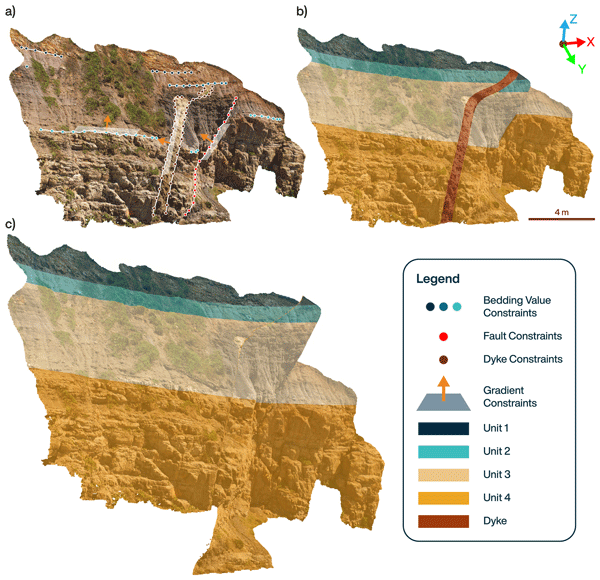
We present Curlew, an open-source Python tool for constructing 3D geological models using machine learning. It integrates diverse spatial data and structural observations into a flexible, event-based framework. Curlew captures complex features like folds and faults, handles uncertainty, and supports learning from sparse or unlabelled data. We demonstrate its capabilities on synthetic and real-world examples.
Samuel T. Thiele, Gabor Kereszturi, Michael J. Heap, Andréa de Lima Ribeiro, Akshay V. Kamath, Maia Kidd, Matías Tramontini, Marina Rosas-Carbajal, and Richard Gloaguen
Solid Earth, 16, 1249–1267, https://doi.org/10.5194/se-16-1249-2025, https://doi.org/10.5194/se-16-1249-2025, 2025
Short summary
Short summary
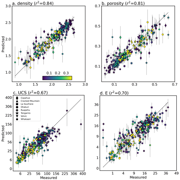
Volcanic rocks are shaped by many processes, including volcanism, chemical alteration and weathering. These processes change the rock's properties, making it difficult to predict volcanic hazards or design tunnels and mines in volcanic areas. In this study, we build on earlier research to connect unique spectral signatures that can be remotely imaged using hyperspectral cameras to the density, porosity, strength, and stiffness of volcanic rocks.
Akshay V. Kamath, Samuel T. Thiele, Hernan Ugalde, Bill Morris, Raimon Tolosana-Delgado, Moritz Kirsch, and Richard Gloaguen
Geosci. Model Dev., 18, 7951–7968, https://doi.org/10.5194/gmd-18-7951-2025, https://doi.org/10.5194/gmd-18-7951-2025, 2025
Short summary
Short summary
We present a new machine learning approach to reconstruct gravity and magnetic tensor data from sparse airborne surveys. By treating the data as derivatives of a hidden potential field and enforcing physical laws, our method improves accuracy and captures geological features more clearly. This enables better subsurface imaging in regions where traditional interpolation methods fall short.
Lotte de Vugt, Edoardo Carraro, Ayoub Fatihi, Enrico Mattea, Eleanor Myall, Daniel Czerwonka-Schröder, and Katharina Anders
Int. Arch. Photogramm. Remote Sens. Spatial Inf. Sci., XLVIII-G-2025, 359–365, https://doi.org/10.5194/isprs-archives-XLVIII-G-2025-359-2025, https://doi.org/10.5194/isprs-archives-XLVIII-G-2025-359-2025, 2025
Akshay V. Kamath, Samuel T. Thiele, Moritz Kirsch, and Richard Gloaguen
Solid Earth, 16, 351–365, https://doi.org/10.5194/se-16-351-2025, https://doi.org/10.5194/se-16-351-2025, 2025
Short summary
Short summary
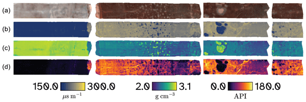
We developed a deep learning model that uses hyperspectral imaging data to predict key physical rock properties, specifically density, slowness, and gamma-ray values. Our model successfully learned to translate hyperspectral information into predicted physical properties. Tests on independent data gave accurate results, demonstrating the potential of hyperspectral data for mapping physical rock properties.
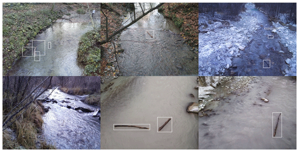
Janbert Aarnink, Tom Beucler, Marceline Vuaridel, and Virginia Ruiz-Villanueva
Earth Surf. Dynam., 13, 167–189, https://doi.org/10.5194/esurf-13-167-2025, https://doi.org/10.5194/esurf-13-167-2025, 2025
Short summary
Short summary
This study presents a novel convolutional-neural-network approach for detecting instream large wood in rivers, addressing the need for flexible monitoring methods across diverse data sources. Using a database of 15 228 fully labelled images, the model achieved a weighted mean average precision of 67 %. Fine-tuning parameters and sampling techniques can improve performance by over 10 % in some cases, offering valuable insights into ecosystem management.
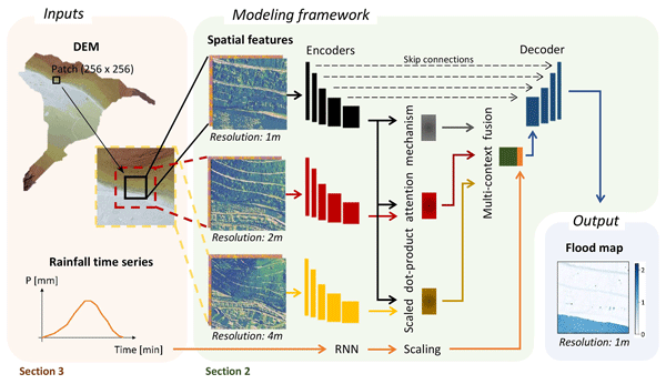
Tabea Cache, Milton Salvador Gomez, Tom Beucler, Jovan Blagojevic, João Paulo Leitao, and Nadav Peleg
Hydrol. Earth Syst. Sci., 28, 5443–5458, https://doi.org/10.5194/hess-28-5443-2024, https://doi.org/10.5194/hess-28-5443-2024, 2024
Short summary
Short summary
We introduce a new deep-learning model that addresses the limitations of existing urban flood models in handling varied terrains and rainfall events. Our model subdivides a city into small patches and presents a novel approach to incorporate broader terrain information. It accurately predicts high-resolution flood maps across diverse rainfall events and cities (on minute and meter scales) that haven’t been seen by the model, which offers valuable insights for urban flood mitigation strategies.
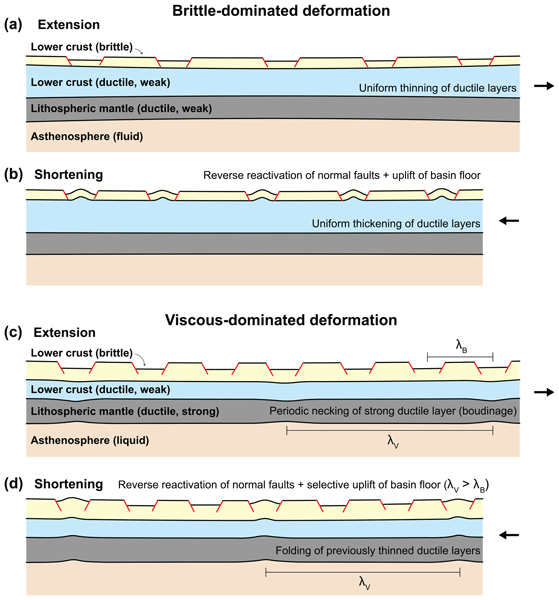
Anindita Samsu, Weronika Gorczyk, Timothy Chris Schmid, Peter Graham Betts, Alexander Ramsay Cruden, Eleanor Morton, and Fatemeh Amirpoorsaeed
Solid Earth, 14, 909–936, https://doi.org/10.5194/se-14-909-2023, https://doi.org/10.5194/se-14-909-2023, 2023
Short summary
Short summary
When a continent is pulled apart, it breaks and forms a series of depressions called rift basins. These basins lie above weakened crust that is then subject to intense deformation during subsequent tectonic compression. Our analogue experiments show that when a system of basins is squeezed in a direction perpendicular to the main trend of the basins, some basins rise up to form mountains while others do not.
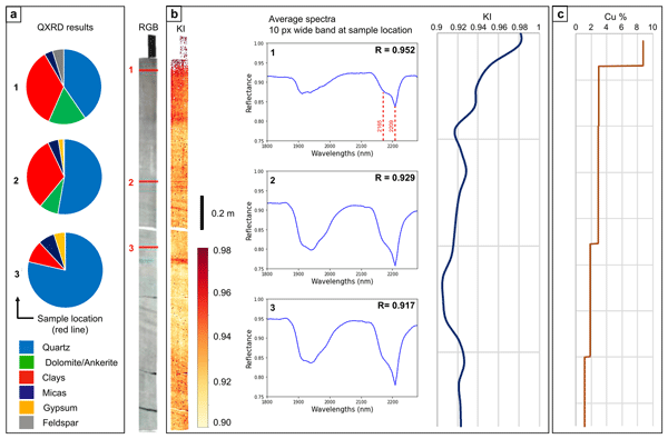
Léa Géring, Moritz Kirsch, Samuel Thiele, Andréa De Lima Ribeiro, Richard Gloaguen, and Jens Gutzmer
Solid Earth, 14, 463–484, https://doi.org/10.5194/se-14-463-2023, https://doi.org/10.5194/se-14-463-2023, 2023
Short summary
Short summary
We apply multi-range hyperspectral imaging on drill core material from a Kupferschiefer-type Cu–Ag deposit in Germany, mapping minerals such as iron oxides, kaolinite, sulfate, and carbonates at millimetre resolution and in a rapid, cost-efficient, and continuous manner to track hydrothermal fluid flow paths and vectors towards base metal deposits in sedimentary basins.
Cited articles
Abid, A., Abdalla, A., Abid, A., Khan, D., Alfozan, A., and Zou, J.: Gradio: Hassle-Free Sharing and Testing of ML Models in the Wild, arXiv, https://doi.org/10.48550/arXiv.1906.02569, 2019. a
Adiri, Z., El Harti, A., Jellouli, A., Lhissou, R., Maacha, L., Azmi, M., Zouhair, M., and Bachaoui, E. M.: Comparison of Landsat-8, ASTER and Sentinel 1 Satellite Remote Sensing Data in Automatic Lineaments Extraction: A Case Study of Sidi Flah-Bouskour Inlier, Moroccan Anti Atlas, Adv. Space Res., 60, 2355–2367, https://doi.org/10.1016/j.asr.2017.09.006, 2017. a, b
Aghaee, A., Shamsipour, P., Hood, S., and Haugaard, R.: A Convolutional Neural Network for Semi-Automated Lineament Detection and Vectorisation of Remote Sensing Data Using Probabilistic Clustering: A Method and a Challenge, Comput. Geosci., 151, 104724, https://doi.org/10.1016/j.cageo.2021.104724, 2021. a
An, Y., Du, H., Ma, S., Niu, Y., Liu, D., Wang, J., Du, Y., Childs, C., Walsh, J., and Dong, R.: Current State and Future Directions for Deep Learning Based Automatic Seismic Fault Interpretation: A Systematic Review, Earth-Sci. Rev., 243, 104509, https://doi.org/10.1016/j.earscirev.2023.104509, 2023. a, b, c
Andrews, B. J., Roberts, J. J., Shipton, Z. K., Bigi, S., Tartarello, M. C., and Johnson, G.: How do we see fractures? Quantifying subjective bias in fracture data collection, Solid Earth, 10, 487–516, https://doi.org/10.5194/se-10-487-2019, 2019. a
Aydin, A.: Fractures, Faults, and Hydrocarbon Entrapment, Migration and Flow, Mar. Petrol. Geol., 17, 797–814, https://doi.org/10.1016/S0264-8172(00)00020-9, 2000. a
Badoux, H., Bonnard, E. G., and Burri, M.: Atlas géologique de la Suisse 1:25 000, feuille 1286 St-Léonard, avec annexe de la feuille Sion (feuille 35 de l'Atlas), Schweizerische Geologische Kommission, Kümmerly & Frey, Bern, https://data.geo.admin.ch/ch.swisstopo.geologie-geologischer_atlas/erlaeuterungen/GA25-ERL-35.pdf (last access: 25 September 2026), 1959. a
Bemis, S. P., Micklethwaite, S., Turner, D., James, M. R., Akciz, S., Thiele, S. T., and Bangash, H. A.: Ground-Based and UAV-Based Photogrammetry: A Multi-Scale, High-Resolution Mapping Tool for Structural Geology and Paleoseismology, J. Struct. Geol., 69, 163–178, https://doi.org/10.1016/j.jsg.2014.10.007, 2014. a, b
Berkowitz, B.: Characterizing Flow and Transport in Fractured Geological Media: A Review, Adv. Water Resour., 25, 861–884, https://doi.org/10.1016/S0309-1708(02)00042-8, 2002. a
Bonnet, E., Bour, O., Odling, N. E., Davy, P., Main, I., Cowie, P., and Berkowitz, B.: Scaling of Fracture Systems in Geological Media, Rev. Geophys., 39, 347–383, https://doi.org/10.1029/1999RG000074, 2001. a
Candès, E. J. and Donoho, D. L.: Continuous Curvelet Transform: I. Resolution of the Wavefront Set, Appl. Comput. Harmon. A., 19, 162–197, https://doi.org/10.1016/j.acha.2005.02.003, 2005. a, b
Candès, E. J. and Guo, F.: New Multiscale Transforms, Minimum Total Variation Synthesis: Applications to Edge-Preserving Image Reconstruction, Signal Process., 82, 1519–1543, https://doi.org/10.1016/S0165-1684(02)00300-6, 2002. a, b
Constantine, A.: Sedimentology, Stratigraphy and Palaeoenvironment of the Upper Jurassic-Lower Cretaceous Non-Marine Strzelecki Group, Gippsland Basin, Southeastern Australia, PhD thesis, Monash University, 2001. a
Coulibaly, H. S. J. P., Coulibaly, T. J. H., Coulibaly, N., Kouadio, K. C. A., Didi, S. R. M., Diedhiou, A., and Savane, I.: Groundwater Exploration Using Extraction of Lineaments from SRTM DEM and Water Flows in Béré Region, Egyptian Journal of Remote Sensing and Space Science, 24, 391–400, https://doi.org/10.1016/j.ejrs.2020.07.003, 2021. a, b
Do, M. and Vetterli, M.: The Contourlet Transform: An Efficient Directional Multiresolution Image Representation, IEEE T. Image Process., 14, 2091–2106, https://doi.org/10.1109/TIP.2005.859376, 2005. a, b
Duda, R. O. and Hart, P. E.: Use of the Hough Transformation to Detect Lines and Curves in Pictures, Commun. ACM, 15, 11–15, https://doi.org/10.1145/361237.361242, 1972. a, b
Fan, J. and Ni, C.: Comparative Studies on the Extraction of Lineaments and Its Variability Based on an Improved Line Segment Tracking Method—Taking the Gaosong Ore Field in the Gejiu Gejiu Tin Ore Deposit as an Example, Appl. Sci., 13, 1314, https://doi.org/10.3390/app13031314, 2023. a, b, c
Fatihi, A. and Thiele, S.: ayoubft/fractex2D.pt, Zenodo [code], https://doi.org/10.5281/zenodo.17953223, 2025. a
Fatihi, A., Caldeira, J., Beucler, T., Thiele, S., and Samsu, A.: FraXet, Zenodo [data set], https://doi.org/10.5281/zenodo.17069947, 2025a. a, b
Fatihi, A., Caldeira, J., Beucler, T., Thiele, S., and Samsu, A.: Fracture Mapping Models Trained on FraXet, Zenodo [code], https://doi.org/10.5281/zenodo.17866853, 2025b. a
Gaikwad, V., Singh, K., Salunke, V., and Kudnar, N.: GIS-based Comparative Analysis of Lineament Extraction by Using Different Azimuth Angles: A Case Study of Mula River Basin, Maharashtra, India, Arab. J. Geosci., 16, 538, https://doi.org/10.1007/s12517-023-11636-2, 2023. a, b, c
Guo, Y.: Augmentation Is AUtO-Net: Augmentation-Driven Contrastive Multiview Learning for Medical Image Segmentation, arXiv, https://doi.org/10.48550/arXiv.2311.01023, 2023. a
Han, L., Liu, Z., Ning, Y., and Zhao, Z.: Extraction and Analysis of Geological Lineaments Combining a DEM and Remote Sensing Images from the Northern Baoji Loess Area, Adv. Space Res., 62, 2480–2493, https://doi.org/10.1016/j.asr.2018.07.030, 2018. a, b
Härmä, P.: Natural Stone Exploration in the Classic Wiborg Rapakivi Granite Batholith of Southeastern Finland – New Insights from Integration of Lithological, Geophysical and Structural Data, PhD thesis, Department of Geosciences and Geography, University of Helsinki, 2020. a
Kirillov, A., Mintun, E., Ravi, N., Mao, H., Rolland, C., Gustafson, L., Xiao, T., Whitehead, S., Berg, A. C., Lo, W.-Y., Dollár, P., and Girshick, R.: Segment Anything, arXiv, https://doi.org/10.48550/arXiv.2304.02643, 2023. a
Koike, K., Nagano, S., and Ohmi, M.: Lineament Analysis of Satellite Images Using a Segment Tracing Algorithm (STA), Comput. Geosci., 21, 1091–1104, https://doi.org/10.1016/0098-3004(95)00042-7, 1995. a, b, c
Kovesi, P.: Phase Congruency: A Low-Level Image Invariant, Psychological Research, 64, 136–148, https://doi.org/10.1007/s004260000024, 2000. a, b
Krieger, M. L. H.: Geology of the Prescott and Paulden Quadrangles, Arizona, Tech. Rep. 467, U. S. Govt. Print. Off., https://doi.org/10.3133/pp467, 1965. a
Kuş, Z. and Aydin, M.: MedSegBench: A Comprehensive Benchmark for Medical Image Segmentation in Diverse Data Modalities, Sci. Data, 11, 1283, https://doi.org/10.1038/s41597-024-04159-2, 2024. a
LeCun, Y., Bengio, Y., and Hinton, G.: Deep Learning, Nature, 521, 436–444, https://doi.org/10.1038/nature14539, 2015. a, b, c
Mallat, S. and Hwang, W.: Singularity Detection and Processing with Wavelets, IEEE T. Inform. Theory, 38, 617–643, https://doi.org/10.1109/18.119727, 1992. a, b
Masoud, A. and Koike, K.: Applicability of Computer-Aided Comprehensive Tool (LINDA: LINeament Detection and Analysis) and Shaded Digital Elevation Model for Characterizing and Interpreting Morphotectonic Features from Lineaments, Comput. Geosci., 106, 89–100, https://doi.org/10.1016/j.cageo.2017.06.006, 2017. a, b
Masoud, A. A. and Koike, K.: Auto-Detection and Integration of Tectonically Significant Lineaments from SRTM DEM and Remotely-Sensed Geophysical Data, ISPRS J. Photogramm., 66, 818–832, https://doi.org/10.1016/j.isprsjprs.2011.08.003, 2011. a, b
Mattéo, L., Manighetti, I., Tarabalka, Y., Gaucel, J.-M., van den Ende, M., Mercier, A., Tasar, O., Girard, N., Leclerc, F., Giampetro, T., Dominguez, S., and Malavieille, J.: Dataset of manuscript “Automatic fault mapping in remote optical images and topographic data with deep learning”, Zenodo [data set], https://doi.org/10.5281/zenodo.4611494, 2020. a, b, c, d, e
Mattéo, L., Manighetti, I., Tarabalka, Y., Gaucel, J.-M., van den Ende, M., Mercier, A., Tasar, O., Girard, N., Leclerc, F., Giampetro, T., Dominguez, S., and Malavieille, J.: Automatic Fault Mapping in Remote Optical Images and Topographic Data With Deep Learning, J. Geophys. Res.-Sol. Ea., 126, e2020JB021269, https://doi.org/10.1029/2020JB021269, 2021. a, b, c, d, e, f, g
Oliveira, M. J., Savastano, V., Matos, G., Schmitt, R., Valente, V., Araujo, M., and Inocencio, L.: The Use of Drones and Deep Learning to Identify Igneous Rocks and Fractures, in: Offshore Technology Conference Brasil, https://doi.org/10.4043/29829-MS, 2019. a, b
Ovaskainen, N. and Nordbäck, N.: Manually Mapped Traces from UAV-acquired Images of Loviisa Shoreline Outcrops, Zenodo [data set], https://doi.org/10.5281/zenodo.7077846, 2022. a, b, c
Ovaskainen, N., Skyttä, P., Nordbäck, N., and Engström, J.: Detailed investigation of multi-scale fracture networks in glacially abraded crystalline bedrock at Åland Islands, Finland, Solid Earth, 14, 603–624, https://doi.org/10.5194/se-14-603-2023, 2023. a
Palamakumbura, R., Krabbendam, M., Whitbread, K., and Arnhardt, C.: Data acquisition by digitizing 2-D fracture networks and topographic lineaments in geographic information systems: further development and applications, Solid Earth, 11, 1731–1746, https://doi.org/10.5194/se-11-1731-2020, 2020. a
Peacock, D. C. P. and Sanderson, D. J.: Influences of Map Resolution, Quality and Interpretation on Fault Network Topology, Earth-Sci. Rev., 277, 105461, https://doi.org/10.1016/j.earscirev.2026.105461, 2026. a
Peacock, D. C. P., Sanderson, D. J., Bastesen, E., Rotevatn, A., and Storstein, T. H.: Causes of Bias and Uncertainty in Fracture Network Analysis, Norw. J. Geol., 99, 113–128, https://doi.org/10.17850/njg99-1-06, 2019. a
Pola, A., Herrera-Díaz, A., Tinoco-Martínez, S. R., Macias, J. L., Soto-Rodríguez, A. N., Soto-Herrera, A. M., Sereno, H., and Ramón Avellán, D.: Rock Characterization, UAV Photogrammetry and Use of Algorithms of Machine Learning as Tools in Mapping Discontinuities and Characterizing Rock Masses in Acoculco Caldera Complex, B. Eng. Geol. Environ., 83, 260, https://doi.org/10.1007/s10064-024-03743-5, 2024. a, b
Potts, G. J.: Simple Rule to Assist in the Construction of the Outcrop Trace of an Inclined Surface, J. Struct. Geol., 165, 104749, https://doi.org/10.1016/j.jsg.2022.104749, 2022. a, b
Prabhakaran, R., Bruna, P.-O., Bertotti, G., and Smeulders, D.: An automated fracture trace detection technique using the complex shearlet transform, Solid Earth, 10, 2137–2166, https://doi.org/10.5194/se-10-2137-2019, 2019. a, b, c
Raghavan, V., Wadatsumi, K., and Masumoto, S.: Automatic Extraction of Lineament Information from Satellite Images Using Digital Elevation Data, Nonrenewable Resources, 2, 148–155, https://doi.org/10.1007/BF02272811, 1993. a, b, c
Raghavan, V., Masumoto, S., Koike, K., and Nagano, S.: Automatic Lineament Extraction from Digital Images Using a Segment Tracing and Rotation Transformation Approach, Comput. Geosci., 21, 555–591, https://doi.org/10.1016/0098-3004(94)00097-E, 1995. a, b
Rahnama, M. and Gloaguen, R.: TecLines: A MATLAB-Based Toolbox for Tectonic Lineament Analysis from Satellite Images and DEMs, Part 1: Line Segment Detection and Extraction, Remote Sens., 6, 5938–5958, https://doi.org/10.3390/rs6075938, 2014. a, b
Ren, X. and Malik, J.: Learning a Classification Model for Segmentation, in: Proceedings Ninth IEEE International Conference on Computer Vision, vol.1, IEEE, Nice, France, pp. 10–17, https://doi.org/10.1109/ICCV.2003.1238308, 2003. a, b, c
Ronneberger, O., Fischer, P., and Brox, T.: U-Net: Convolutional Networks for Biomedical Image Segmentation, in: Medical Image Computing and Computer-Assisted Intervention – MICCAI 2015, edited by: Navab, N., Hornegger, J., Wells, W. M., and Frangi, A. F., Lecture Notes in Computer Science, Springer International Publishing, Cham, pp. 234–241, https://doi.org/10.1007/978-3-319-24574-4_28, 2015. a, b
Sanderson, D. J. and Nixon, C. W.: The Use of Topology in Fracture Network Characterization, J. Struct. Geol., 72, 55–66, https://doi.org/10.1016/j.jsg.2015.01.005, 2015. a
Scheiber, T., Fredin, O., Viola, G., Jarna, A., Gasser, D., and Łapińska-Viola, R.: Manual Extraction of Bedrock Lineaments from High-Resolution LiDAR Data: Methodological Bias and Human Perception, GFF, 137, 362–372, https://doi.org/10.1080/11035897.2015.1085434, 2015. a, b
Smeraglia, L., Mercuri, M., Tavani, S., Pignalosa, A., Kettermann, M., Billi, A., and Carminati, E.: 3D Discrete Fracture Network (DFN) Models of Damage Zone Fluid Corridors within a Reservoir-Scale Normal Fault in Carbonates: Multiscale Approach Using Field Data and UAV Imagery, Mar. Petrol. Geol., 126, 104902, https://doi.org/10.1016/j.marpetgeo.2021.104902, 2021. a
Soto-Pinto, C., Arellano-Baeza, A., and Sánchez, G.: A New Code for Automatic Detection and Analysis of the Lineament Patterns for Geophysical and Geological Purposes (ADALGEO), Comput. Geosci., 57, 93–103, https://doi.org/10.1016/j.cageo.2013.03.019, 2013. a, b, c
Steck, A., Epard, J.-L., Escher, A., Gouffon, Y., and Masson, H.: Carte tectonique des Alpes de Suisse occidentale 1:100 000, Office féd. Eaux Géologie (Berne), 2001. a
Sumi, M. R., Das, P., Hossain, A., Dey, S., and Schuckers, S.: A Comprehensive Evaluation of Iris Segmentation on Benchmarking Datasets, Sensors, 24, 7079, https://doi.org/10.3390/s24217079, 2024. a
swisstopo: Tectonic Map of Switzerland 1:500 000, Federal Office of Topography Swisstopo, Wabern, 2024. a
Thiele, S., Vollgger, S., and Samsu, A.: GeoTrace and Compass Rapid Trace-Mapping (Example Data), Monash University [data set], https://doi.org/10.4225/03/5981B31091AF9, 2017a. a, b
Vasuki, Y., Holden, E.-J., Kovesi, P., and Micklethwaite, S.: Semi-Automatic Mapping of Geological Structures Using UAV-based Photogrammetric Data: An Image Analysis Approach, Comput. Geosci., 69, 22–32, https://doi.org/10.1016/j.cageo.2014.04.012, 2014. a, b, c, d
Vasuki, Y., Holden, E.-J., Kovesi, P., and Micklethwaite, S.: An Interactive Image Segmentation Method for Lithological Boundary Detection: A Rapid Mapping Tool for Geologists, Comput. Geosci., 100, 27–40, https://doi.org/10.1016/j.cageo.2016.12.001, 2017. a, b
Villarreal, C. A., Garzón, C. G., Mora, J. P., Rojas, J. D., and Ríos, C. A.: Workflow for Capturing Information and Characterizing Difficult-to-Access Geological Outcrops Using Unmanned Aerial Vehicle-Based Digital Photogrammetric Data, Journal of Industrial Information Integration, 26, 100292, https://doi.org/10.1016/j.jii.2021.100292, 2022. a
Wang, Y., Khodadadzadeh, M., and Zurita-Milla, R.: Spatial+: A New Cross-Validation Method to Evaluate Geospatial Machine Learning Models, Int. J. Appl. Earth Obs., 121, 103364, https://doi.org/10.1016/j.jag.2023.103364, 2023. a
Weismüller, C., Prabhakaran, R., Passchier, M., Urai, J. L., Bertotti, G., and Reicherter, K.: Mapping the fracture network in the Lilstock pavement, Bristol Channel, UK: manual versus automatic, Solid Earth, 11, 1773–1802, https://doi.org/10.5194/se-11-1773-2020, 2020. a
Xie, E., Wang, W., Yu, Z., Anandkumar, A., Alvarez, J. M., and Luo, P.: SegFormer: Simple and Efficient Design for Semantic Segmentation with Transformers, arXiv, https://doi.org/10.48550/arXiv.2105.15203, 2021. a, b
Yaqoob, M., Ishaq, M., Ansari, M. Y., Konagandla, V. R. S., Tamimi, T. A., Tavani, S., Corradetti, A., and Seers, T. D.: GeoCrack: A High-Resolution Dataset For Segmentation of Fracture Edges in Geological Outcrops, Sci. Data, 11, 1318, https://doi.org/10.1038/s41597-024-04107-0, 2024. a, b, c
Zhang, R., Yi, X., Li, H., and Lu, G.: Automatic Extraction of Geological Discontinuities of a Tunnel Surface by Integrating Multiple Features, Tunn. Undergr. Sp. Tech., 154, 106072, https://doi.org/10.1016/j.tust.2024.106072, 2024. a, b, c, d
Short summary
Mapping rock fractures in high resolution aerial images is essential for understanding Earth processes and managing resources, but manual tracing is slow and inconsistent. We created FraXet, a large harmonized dataset of nearly nine thousand images, and compared standard image filters with modern deep learning models. The deep learning methods were far more accurate and produced smoother, more reliable maps, while also showing where results are uncertain.
Mapping rock fractures in high resolution aerial images is essential for understanding Earth...


