
the Creative Commons Attribution 4.0 License.
the Creative Commons Attribution 4.0 License.
 | 13 Nov 2026
Solid-Earth geophysics and geodesy in Antarctica: achievements, current capabilities, and future directions
Mirko Scheinert

Weisen Shen
Richard C. Aster
Lambert Caron
Michael D. Hartinger
Matt A. King
Andrew Lloyd
Anya M. Reading
J. Paul Winberry
Terry Wilson
Lucilla Alfonsi
Michael J. Bentley
Eric Buchta
Thomas Y. Chen
Peter J. Clarke
Jörg Ebbing
Olaf Eisen
Natalya Gomez
Esra Günaydın
Samantha Hansen
Erik R. Ivins
Achraf Koulali
Grace A. Nield
Frederick Richards
M. Oğuz Selbesoğlu
Stephanie Sherman
Pippa L. Whitehouse
Matthias Willen
The Antarctic Ice Sheet (AIS) plays a major role in the global climate, providing a natural laboratory to study the processes that interlink the cryosphere, solid Earth, atmosphere, and hydrosphere. Through its ongoing mass loss, the AIS currently contributes to global-mean sea-level rise at a rate of 0.4 mm a−1. However, its impact on and feedback with climate and sea-level changes are still poorly understood. To generate reliable sea-level projections for the future, there is an urgent need to substantially improve our knowledge of the solid-Earth properties and subsequent response to ice-mass variations in space and time. This issue has been identified as a key question by the international community, strongly supported by the Scientific Committee on Antarctic Research (SCAR).
We review how state-of-the-art Global Navigation Satellite Systems (GNSS) and seismic networks in Antarctica, in combination with further ground-based, airborne and satellite-based geophysical measurements, have been used to significantly advance our understanding of solid-Earth processes and their impact on the cryosphere. Future research activities should be coordinated to answer the most urgent science questions. For example, how can we consistently test and model, respectively, a realistic mantle rheology that includes lateral inhomogeneity and transient relaxation, together with AIS mass changes on all time scales since the Last Glacial Maximum, including Holocene retreat and readvance? What processes and boundary conditions should coupled ice-sheet/gravity-rotation-deformation models include in order to realistically reflect the complex interaction between the solid Earth, ice sheet and ocean? Based on the recent achievements and the most urgent science questions, a vision is articulated for science-driven, multidisciplinary geophysical observations and corresponding technological developments. Long-term observations and improved modelling must be combined to develop precise and reliable projections for Antarctica's future mass change and associated contribution to sea-level change at both regional and global scales.
- Article
(20880 KB) - Full-text XML
- BibTeX
- EndNote


Antarctica hosts the largest contiguous ice mass on Earth, with a maximum thickness of almost 4800 m and a continental extent larger than Europe. Divided into East Antarctica, West Antarctica, and the Antarctic Peninsula (Fig. 1), more than 99.6 % of the continent is covered by glacial ice, comprising approximately 90 % of all global ice coverage and approximately 70 % of Earth's freshwater storage. The entire mass of the Antarctic Ice Sheet (AIS) holds the potential to increase global-mean sea level (GMSL) by 58 m (Pritchard et al., 2025). Antarctica plays a major role in the global climate and in the Earth system, and it provides a natural laboratory to study the feedback processes between the cryosphere, solid Earth, atmosphere, and hydrosphere (Fig. 2; Whitehouse et al., 2019). However, the evolving impact of the AIS on our changing climate and associated sea-level variations has high uncertainty. The IPCC (2023) reported that AIS contributions to the GMSL rate of rise were four times larger during 2010 to 2019 than during 1992 to 1999. From 2003 to 2016, the AIS contribution to GMSL rise was 0.3 (±0.1) mm a−1 (Horwath et al., 2022), and it has further increased to 0.4 (±0.1) mm a−1 (Ludwigsen et al., 2024) in recent years. This corresponds to 11 % of the total GMSL change of 3.72 (±0.3) mm a−1 (ibidem). Separating mass contributions in estimates of GMSL change strongly depend on satellite gravimetry (The IMBIE Team, 2018) which in turn depend on estimates of the glacial isostatic adjustment (GIA) contribution. However, the gravity effect caused by GIA is not well known and, thus, induces a large uncertainty when correcting gravimetric mass-change estimates inferred from measurements by satellite gravimetry missions GRACE and GRACE-FO. The GIA uncertainty alone amounts to about one-third of the total mass change amplitude from 2002 to 2020 (Groh and Horwath, 2021).
To improve projections of Antarctica's future contributions to GMSL rise, we must improve our understanding of the complex interactions between different components of the Earth system, such as those between the cryosphere, solid Earth, and ocean. These processes may either stabilise or destabilise the ice sheet, especially at its margin. For example, marine ice-sheet instability (MISI; Weertman, 1974; Konrad et al., 2015; Gomez et al., 2024), which describes the instability of the evolving mass flux and grounding line position, promotes ice-mass loss. However, the time evolution of ice loss may strongly depend on the underlying evolving bed and solid-Earth characteristics and ocean feedback (cf. Sect. 2.9). On the contrary, GIA might have a stabilising feedback on grounding line migration and flux in regions with considerable uplift (cf. Fig. 2). However, Antarctica's contribution to GMSL rise can even be larger if the marine ice-cliff instability (MICI; Pollard et al., 2015; DeConto and Pollard, 2016; DeConto et al., 2021) complements losses caused by MISI. MICI describes a rapid calving resulting from ice-shelf collapse and may lead to an increased mass loss. Since these mechanisms are given low confidence, the IPCC (2023) did not account for these or other such processes in the “likely range” of GMSL projections. Thus, the upper bound for Antarctica's contribution to projected GMSL at 2100 (relative to 1995–2014) is 0.34 m, but projections that include MICI and MISI increase the estimate to 0.56 m (IPCC, 2023). Ultimately, AIS contributions to GMSL rise are potentially the largest, but also the most uncertain, component in future projections.
To gain a better understanding of how the solid Earth may stabilise or destabilise the AIS demands improved knowledge of Earth's material properties, which govern the solid-Earth response to ice-ocean mass loading and unloading in space and time. This also holds true for improving GIA model predictions, which are crucially needed to reduce the large uncertainty when estimating the AIS mass balance from satellite gravimetry. Networks of ground-based observational stations employing Global Navigation Satellite Systems (GNSS) and seismics, and further geophysical techniques such as magnetotellurics, come into play as they provide measurements from which inferences of bedrock displacement and Earth's rheological properties can be made. Further, ground-based observations are needed to constrain key solid-Earth properties such as density, elastic and anelastic parameters, resistivity, electrical and magnetic properties, and geothermal heat flow. Since the AIS largely prevents direct sampling of the sub-ice geologic materials and structure, geophysical instruments are particularly important in studying Antarctica.
To focus on the key question of Antarctica's contribution to GMSL, the Scientific Committee on Antarctic Research (SCAR) (https://scar.org/, last access: 26 September 2025) initiated its Scientific Research Program “Instabilities and Thresholds in Antarctica” (INSTANT). One focus of this program is to improve the temporal and spatial coverage of ground-based and in-situ observations, which are vital to advancing our understanding of how the solid Earth interacts with the ice, atmosphere, and ocean (Fig. 2). Technique-specific capabilities have not been optimally applied either because of the severe Antarctic environmental conditions or because synergies spanning different techniques and data types are still in development. Therefore, INSTANT established the sub-committee “Probing the Solid Earth and its Interactions” (PSE), which aims to enhance the performance and effectiveness of geophysical networks by substantially improving cooperation between scientists from different disciplines who are collecting ground-based and in-situ measurements in Antarctica and by promoting collaboration between data collection and modelling efforts.
This review paper summarises the achievements made by the scientific community over the last three decades in exploiting geodetic and geophysical observations to investigate Antarctic solid-Earth structure and its interactions with further spheres in the Earth system (Fig. 2). Hereby, we focus on ground-based measurements to determine the present state of the solid Earth and its interplay with ice, ocean and atmosphere. Interlinkages to airborne and satellite-based observations are exemplified to emphasise the benefits of combining multiple techniques. We discuss the state-of-the-art geophysical observational networks that have been deployed in Antarctica as well as broad implications for multidisciplinary research. We articulate a vision for science-driven operations to advance ground-based geophysical observations and instrumentation in Antarctica in the future.
In Sect. 2, we discuss the history of Antarctic geophysical deployments (Sect. 2.1) and the major ground-based observational techniques GNSS (Sect. 2.2) and seismology (Sect. 2.4). This is complemented by concise treatments of further techniques such as tide gauges (Sect. 2.3), gravimetry and magnetometry (Sect. 2.5), magnetotellurics (Sect. 2.6) and direct determinations of geothermal heat flow (Sect. 2.7). Section 2.8 discusses the prospects to gain knowledge by exploiting emerging multidisciplinary studies. The subsequent subsections elaborate on the impacts of the observational and modelling efforts on our understanding of GIA (Sect. 2.9) and on emerging areas for collaboration with the space weather and atmospheric research communities, which have multiple interconnections with geophysical research (Sect. 2.10). Thereafter, Sect. 3 debates the implications for contemporary and future Antarctic investigations by identifying key science priorities (Sect. 3.1), by reconsidering key areas for future geodetic-geophysical observations (Sect. 3.2) and by critically reviewing the current challenges for future progress and sustained operation (Sect. 3.3 and 3.4). Section 4 provides an overall summary of our conclusions. Appendix A lists 28 science questions that are referred to when discussing key science priorities (Sect. 3.1).
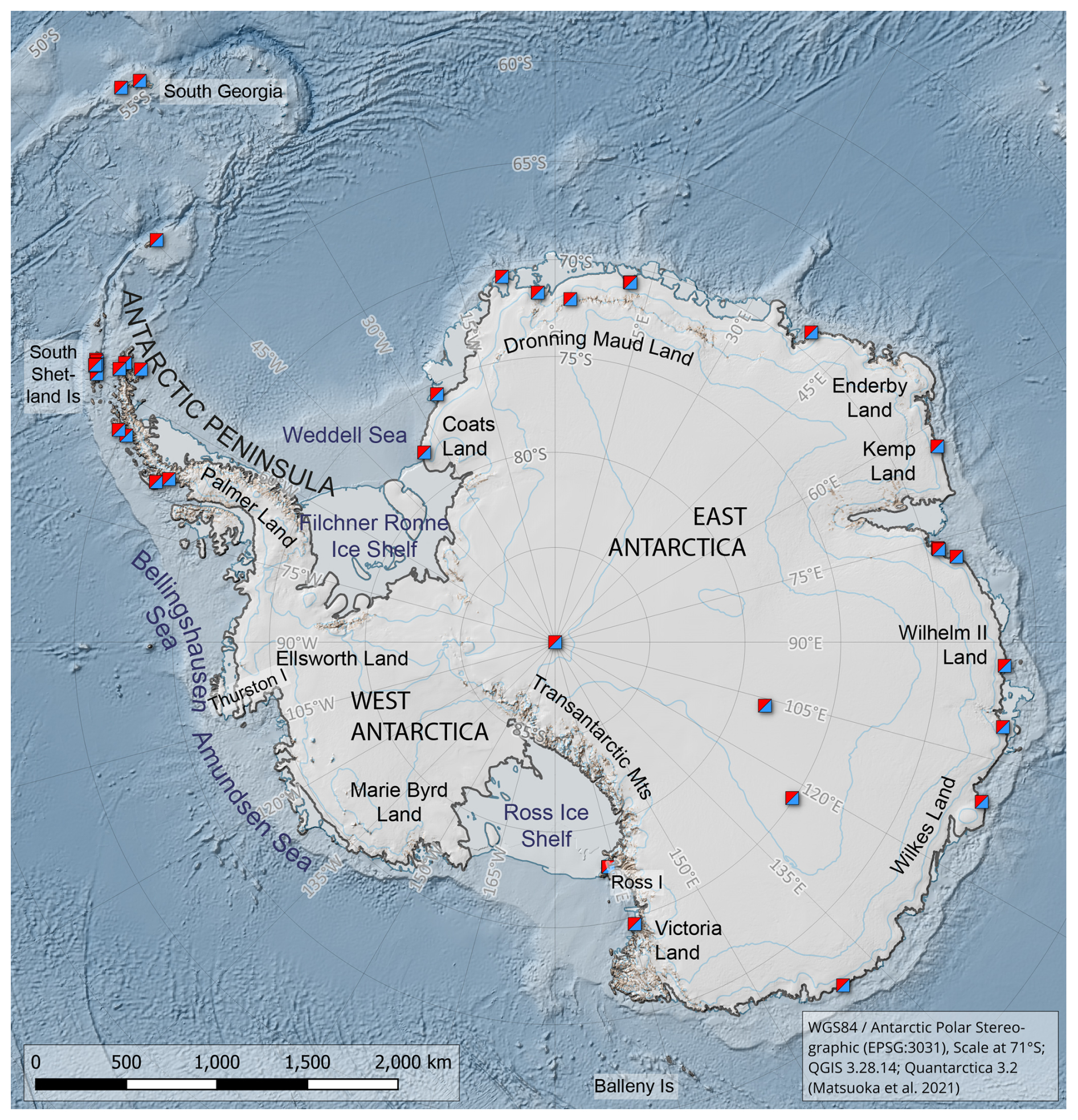
Figure 1Overview map of Antarctica with geographic names mentioned in the text. Also shown are Antarctic overwintering stations (squares); data: Composite Gazetteer of Antarctica, https://placenames.aq/ (last access: 8 November 2026).
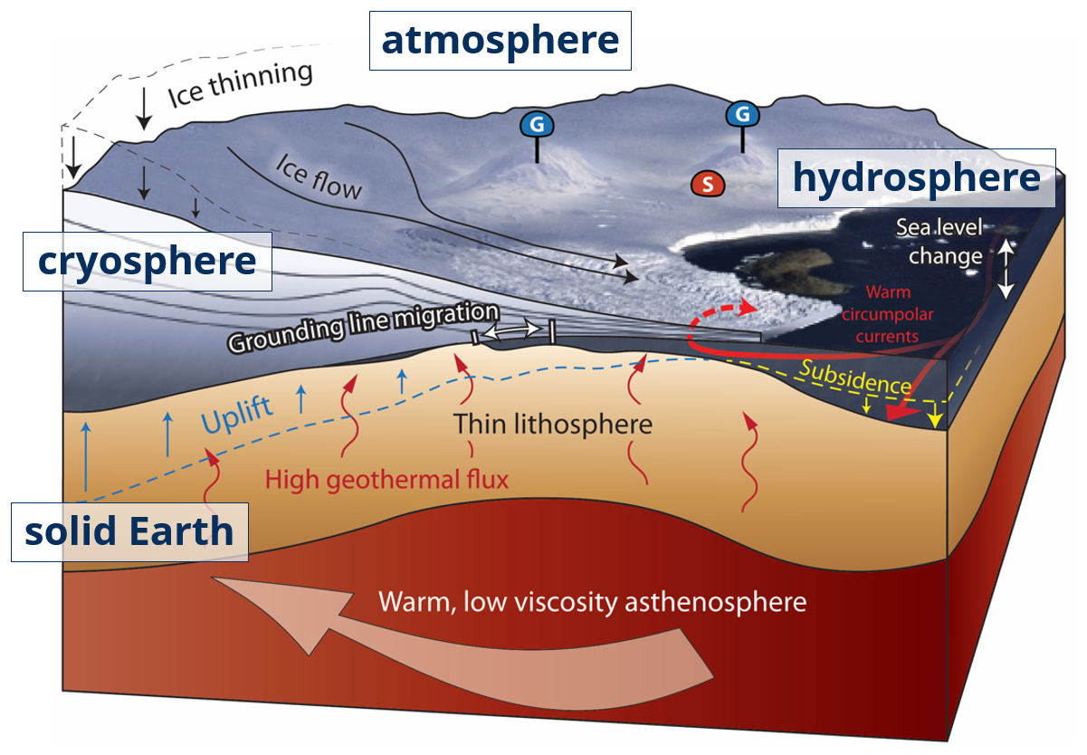
Figure 2Sketch of the processes that interlink the different spheres of Antarctic Earth science. Adapted from Will Blocher and the ANET-POLENET Team (2017).
2.1 Geophysical Deployments Across Antarctica
Since the turn of the millennium, more than 200 seismic stations and more than 200 geodetic GNSS stations on bedrock have been operated across Antarctica (Fig. 3), with a maximum number of daily GNSS observations (about 100) reached in 2016 (Buchta et al., 2025). Over half of these stations have been deployed in West Antarctica, the Antarctic Peninsula, and along the Transantarctic Mountains (Fig. 4). West Antarctica gained special attention since it yields evidence for a different geologic evolution compared to largely cratonic East Antarctica. Caused by the separation of East from West Antarctica between 43 to 26 Ma ago (Cande et al., 2000), the development of the West Antarctic Rift System was accompanied by volcanic activity (especially in Marie Byrd Land) (Zundel et al., 2024). Rifting may have formed deep troughs, possibly expressed now as the Bentley Subglacial Trench or the Mt. Murphy Rift (Spiegel et al., 2016; Zundel et al., 2024).
At present, the West Antarctic Ice Sheet (WAIS) is undergoing major ice-mass loss at a rate of approximately 140 Gt a−1 (The IMBIE Team, 2018; Shepherd et al., 2019), but confidence in this rate is undermined by the GIA uncertainty that amounts to about one-third of the total AIS mass change amplitude from 2002 to 2020 (Groh and Horwath, 2021). GNSS sites used for geodynamic studies must be deployed on exposed bedrock. Such outcrops are more abundant within West Antarctica and the Transantarctic Mountains. On the contrary, seismic instrument deployments do not require placement on bedrock (cf. Figs. 3, 4). In East Antarctica, these have focused on particular geologic features, such as the Gamburtsev Subglacial Mountains. The latter were the focus of a major, coordinated research target during the 4th International Polar Year 2007–2008 (IPY-4). GNSS receivers in East Antarctica are mostly distributed near the continental edge where bedrock exposure is available. The uneven distribution of geophysical networks has left substantial gaps across the continent, not just in East Antarctica but in other notable areas of tectonic interest (e.g., the southern Transantarctic Mountains). These gaps compromise the ability to construct high-resolution data-informed models. Filling these observational gaps in a strategic way has focused discussion within the polar geoscience community, summarised in this paper.
Most of the geophysical networks across Antarctica arose from single- or multiple-PI, hypothesis-driven proposals. Some of these, such as the Polar Earth Observing Network (POLENET)/Antarctic Network (ANET) project (Wiens et al., 2007), have spanned larger geographical areas and have been maintained for longer periods of time (that is, longer than two years) compared to other typical field experiments. Such long-period deployments provide the necessary continuous observations needed for GNSS surface deformation studies and provide greater volumes of seismic event data, but they also impose a higher logistical burden, particularly if they require multiple field visits to retrieve data and for technical maintenance or snow accumulation removal (Aster and Simons, 2015). Balancing logistical requirements, cost, observational duration, and science productivity when designing network deployments is a critical issue for the polar geophysics community. Notably, this need for strategic deployment planning was already articulated in the SEAP2003 AntarcticArray vision (Finn et al., 2003), which called for coordinated Antarctic seismic observations spanning permanent backbone stations, regional arrays, process-oriented experiments, and active-source studies.
Recent technical advances have also improved the quality and completeness of seismic and GNSS data collection in Antarctica. Open data from project deployments allows additional science applications beyond the purposes of their original science objectives. Additionally, these data attract a larger pool of geoscientists into the polar research community. Over the past several years, a growing number of efforts have been aimed at synthesizing collected data, especially during the relatively “quiet era” of fieldwork during and following the COVID-19 pandemic (e.g., Shen et al., 2020; Peña Castro et al., 2024; Buchta et al., 2025). New results from such comprehensive data analyses have demonstrated additional scientific value for the ongoing geophysical infrastructure in Antarctica.
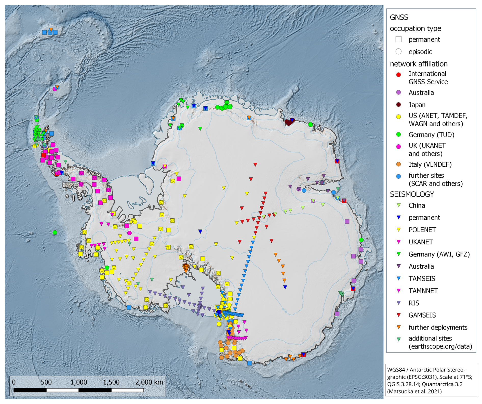
Figure 3Map summarizing the deployment of GNSS and seismic stations across Antarctica over the past three decades. GNSS occupation type is given by square (permanent) and circle (episodic) symbols, respectively. Colors denote network affiliation, differently for GNSS and seismology (triangles). The uneven distribution of these networks leaves large gaps in parts of East Antarctica, including areas of significant tectonic, glaciological, geological, and climate interest. The deployment of plate- and intraplate-motion GNSS stations is constrained to bedrock exposures; therefore, a higher GNSS site density is found in exposed regions of the Antarctic Peninsula, in West Antarctica, and along the Transantarctic Mountains. Shown are stations where data is available at open-access repositories, such as the EarthScope Data Management Center (https://www.earthscope.org/data, last access: 8 November 2026). The GNSS sites correspond to those used in the GIANT-REGAIN project (Buchta et al., 2025).
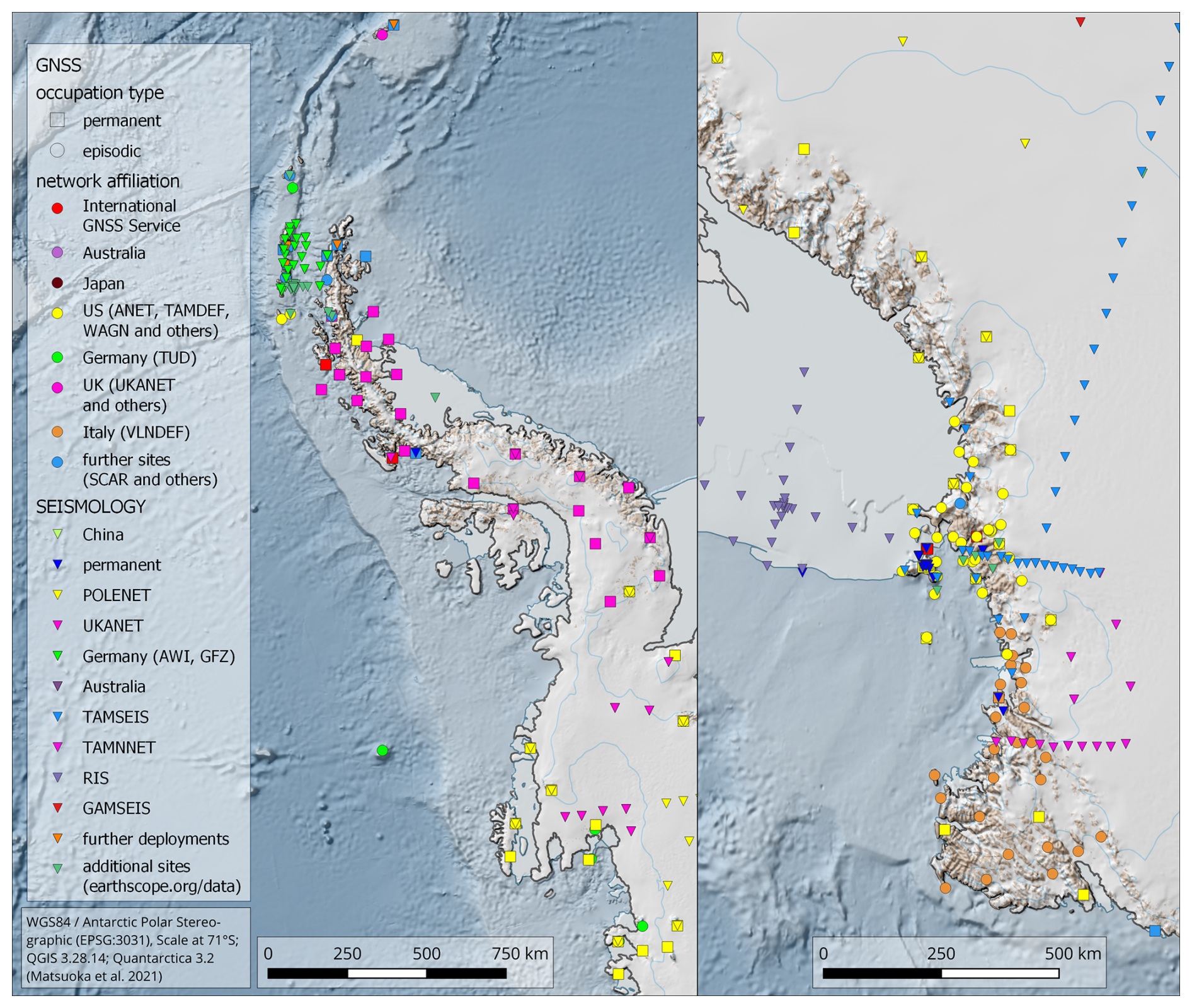
Figure 4Detail maps summarizing the deployment of GNSS and seismic stations over the past three decades, showing the Antarctic Peninsula (left) and the Ross Sea/North Victory Land region (right). For further explanation see Fig. 3.
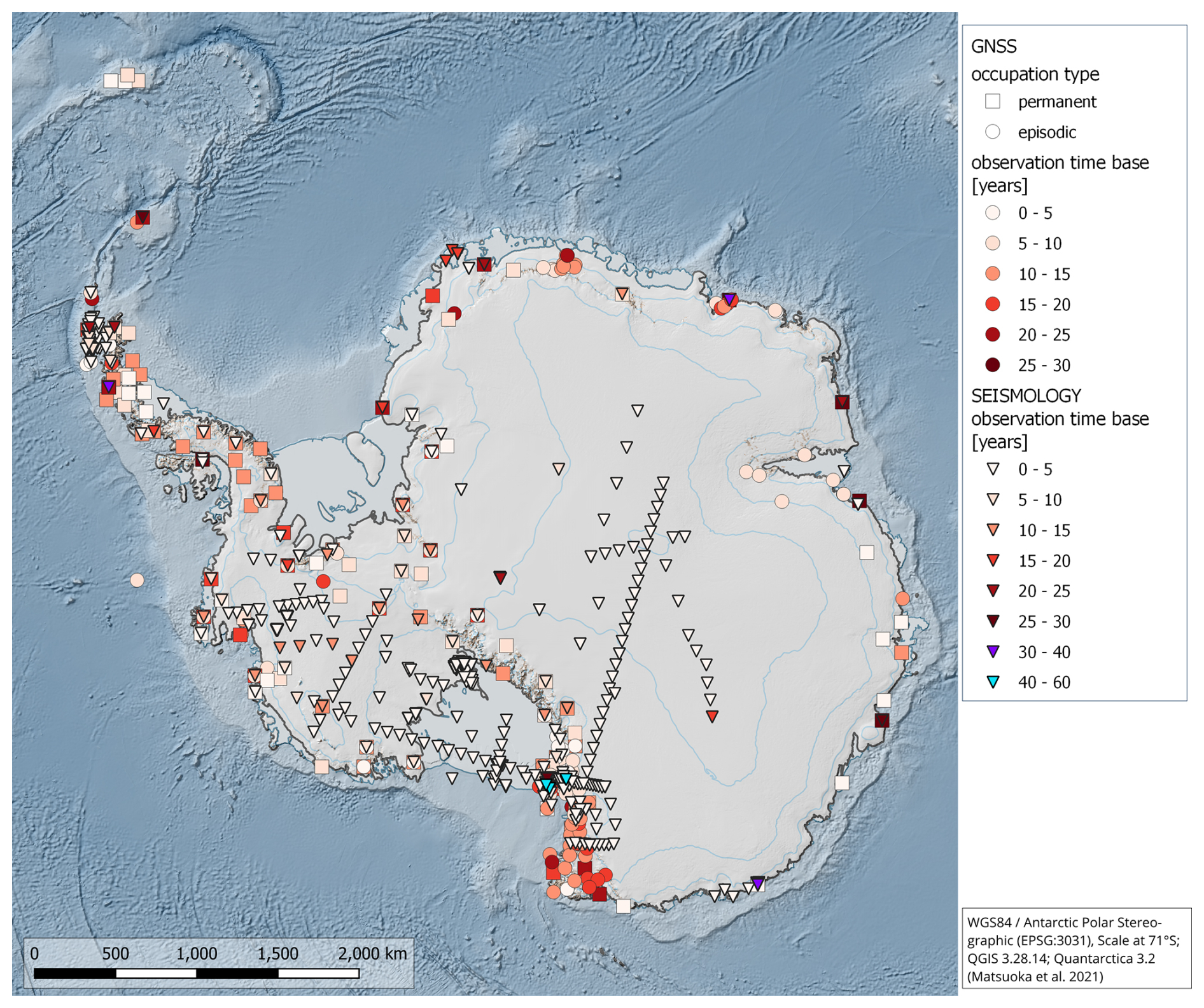
Figure 5Occupation time base for GNSS and seismic stations across Antarctica as of end of 2021 (cf. Fig. 3 for network affiliation and data availability). Color scale for observation times of up to 30 years are the same for GNSS and seismology. GNSS occupation type is given by square (permanent) and circle (episodic), respectively. For seismology, only those stations are shown where a time duration of the deployment could be retrieved.
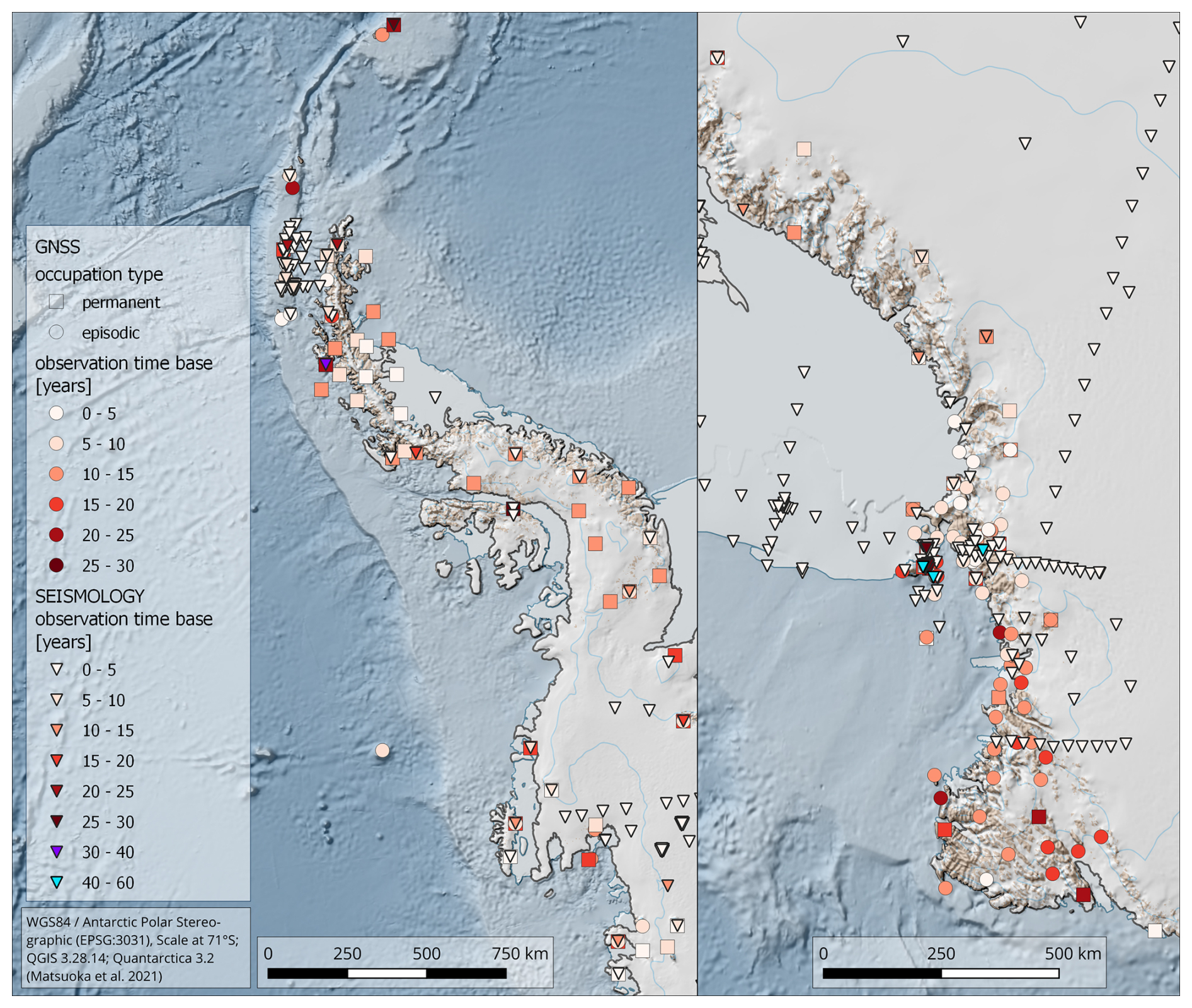
Figure 6Occupation time base for GNSS and seismic stations as of end of 2021. Detailed maps showing the Antarctic Peninsula (left) and the Ross Sea/North Victory Land region (right). For further explanation see Fig. 5.
2.2 GNSS – application of continuous and episodic measurement time series
The deployment of Global Positioning System (GPS) hardware, monumented on bedrock, in Antarctica has revolutionised our understanding of the continent's geodynamics. Before the 1990s, our understanding of Antarctic plate motion and GIA was based on models constrained by observations remote from present-day Antarctica in time and space. At that time, a (largely incorrect) view of the AIS was that it only slowly responded to changes in external forcing. Likewise, the Antarctic solid-Earth structure was viewed as responding only over millennia or longer timescales, driven by past glacial changes and mantle convection. The question of ongoing, internal deformation within Antarctica due to tectonic processes was an untested hypothesis, and the continent was thought to be largely unaffected by recent earthquakes.
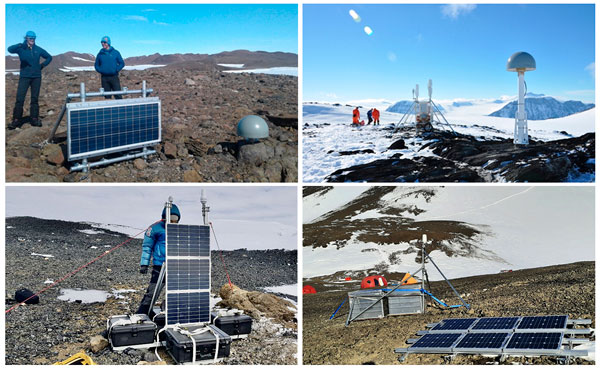
Since the early 1990s, GPS observations (Figs. 5 and 6) have provided direct measurements of Antarctica's changing shape, primarily relative to the International Terrestrial Reference Frame (ITRF; Altamimi et al., 2023). These observational networks have now broadened to GNSS, which include GPS, GLONASS, Galileo and others. Figure 7 provides examples of these systems deployed in the polar region. The data collected have turned previous assumptions on their head and provided fundamental new insights that show solid-Earth processes are as relevant to climate studies as they are to understanding the internal structure of our planet. In the following subsections, we summarise the lessons we have learned from almost three decades of using geodetic GNSS for geodynamic research in Antarctica. A more detailed treatment of this topic and corresponding applications to constrain mantle processes can be found in Scheinert et al. (2023).
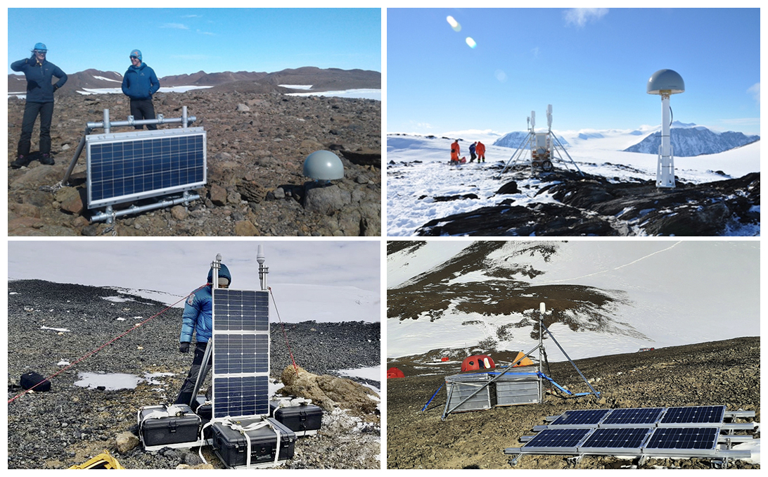
Figure 7Examples of GNSS deployments in Antarctica, showing power systems (comprising solar modules and, optionally, wind generators), radome-covered or compact antennas and various types of monuments. Upper left: Bunger Hills (Queen Mary Coast, East Antarctica); upper right: Hutton Mountains (Palmer Land, Antarctic Peninsula); lower left: Mt. Murphy (Amundsen Sea Embayment, West Antarctica); lower right: Gaussberg (Wilhelm II Coast, East Antarctica).
2.2.1 Plate motion and tectonic processes
The first geodetic estimates of Antarctic plate motion were published in the mid 1990s, based on as few as two GPS sites (Larson et al., 1997) but quickly extending to about ten sites located around the coastal margin of the continent (Sillard et al., 1998). At the same time, GPS epoch measurements were exploited to geodetically determine Antarctic tectonics, especially within the Antarctic Peninsula (Dietrich, 1996). In subsequent years, additional continuous and numerous campaign sites were deployed, yielding estimates of plate rotation based on dozens of measurements (Dietrich et al., 2001; Donnellan and Luyendyk, 2004). These geodetic estimates suggested the absence of significant tectonic deformation within Antarctica but revealed substantial and important differences from geological estimates of plate rotation. Thus, geodetic evidence for a potential active rifting within West Antarctica could not be found. However, ongoing opening of the Bransfield Basin was identified using GPS measurements (e.g., Dietrich and Rülke, 2008; Taylor et al., 2008), showing the deformation of the offshore islands moving about 7 mm a−1 relative to the Antarctic Peninsula.
These analyses assumed any horizontal motion other than that due to tectonic processes was largely negligible for the Antarctic mainland. In recent years, it has been shown that relatively small horizontal deformations associated with GIA (Klemann et al., 2008; King et al., 2016; Vardić et al., 2022) or with post-seismic deformation (King and Santamaría‐Gómez, 2016) may result in non-negligible biases to geodetic estimates of plate rotation (Turner et al., 2020). In the absence of reliable GIA models and the presence of post-seismic horizontal deformation, this issue remains somewhat unresolved.
2.2.2 Co-seismic and post-seismic deformation
The Antarctic continent is located far from major plate boundaries; therefore, tectonic seismic activity is low. However, co-seismic and post-seismic deformation has been detected, and GPS has been used to estimate far-field co-seismic deformation and to constrain fault rupture models (Ye et al., 2014; King and Santamaría‐Gómez, 2016). These observations are especially valuable given the often remote location of the earthquakes and the poor geometry of seismic observations. Using a combination of campaign and continuous GPS data from one remote site, King and Santamaría‐Gómez (2016) showed that a part of East Antarctica experienced co-seismic displacement on the order of 10 mm after the Mw 8.1 Balleny Islands earthquake (Himeno et al., 2011) and then sustained post-seismic deformation over the following two decades. Using viscoelastic models, they suggested that the post-seismic deformation may be non-negligible over much of the continent today. On the other side of Antarctica, Nield et al. (2023) used GPS data and models to suggest that the northern Antarctic Peninsula experienced both co-seismic and ongoing viscoelastic post-seismic deformation following the large 2013 and 2003 Scotia Sea earthquakes.
2.2.3 Glacial isostatic adjustment
Results obtained from geodetic GNSS observations are of utmost scientific value for GIA research as they allow us to verify or falsify results from geophysical GIA modelling. Moreover, GNSS results allow for independent validation of GIA estimates inferred from other geodetic satellite methods, such as satellite gravimetry-altimetry combinations (Riva et al., 2009; Gunter et al., 2014; Sasgen et al., 2017; Engels et al., 2018; Willen et al., 2024). Further, GNSS measurements are used to constrain geophysical (e.g., Caron et al., 2018) and empirical GIA models (e.g., Martín‐Español et al., 2016; Sasgen et al., 2017; Willen et al., 2025). For a more extensive review on GIA in Antarctica, including numerical modelling, inputs, observations and key inferences, the reader is referred to van der Wal et al. (2023).
The first observations of vertical velocities ascribed to GIA began to emerge in the mid-to-late 2000s (Tregoning et al., 1999, 2000; Raymond et al., 2004; Dietrich and Rülke, 2008; Bevis et al., 2009). The number of sites for which vertical velocities were reported grew relatively quickly over the following years, especially in West Antarctica and in coastal regions (Argus et al., 2011; Thomas et al., 2011a). Compared with available GIA models at that time, the GPS velocities had a different spatial pattern, often with lower uplift rates (Thomas et al., 2011a). Subsequent site densification, especially in the Antarctic Peninsula and West Antarctica, has further supported this broad pattern (Fig. 8). Although more recent GIA models are in somewhat better agreement with the GPS velocities (Whitehouse et al., 2012; Ivins et al., 2013), disagreements of more than 10 mm a−1 are evident in some locations (Martín‐Español et al., 2016; Liu et al., 2018). Further progress in understanding GIA, as well as other geodynamic processes in Antarctica, can be expected with the recently published coordinate time series consistently analyzed by the GIANT-REGAIN project for about 280 geodetic GNSS sites (Buchta et al., 2025).
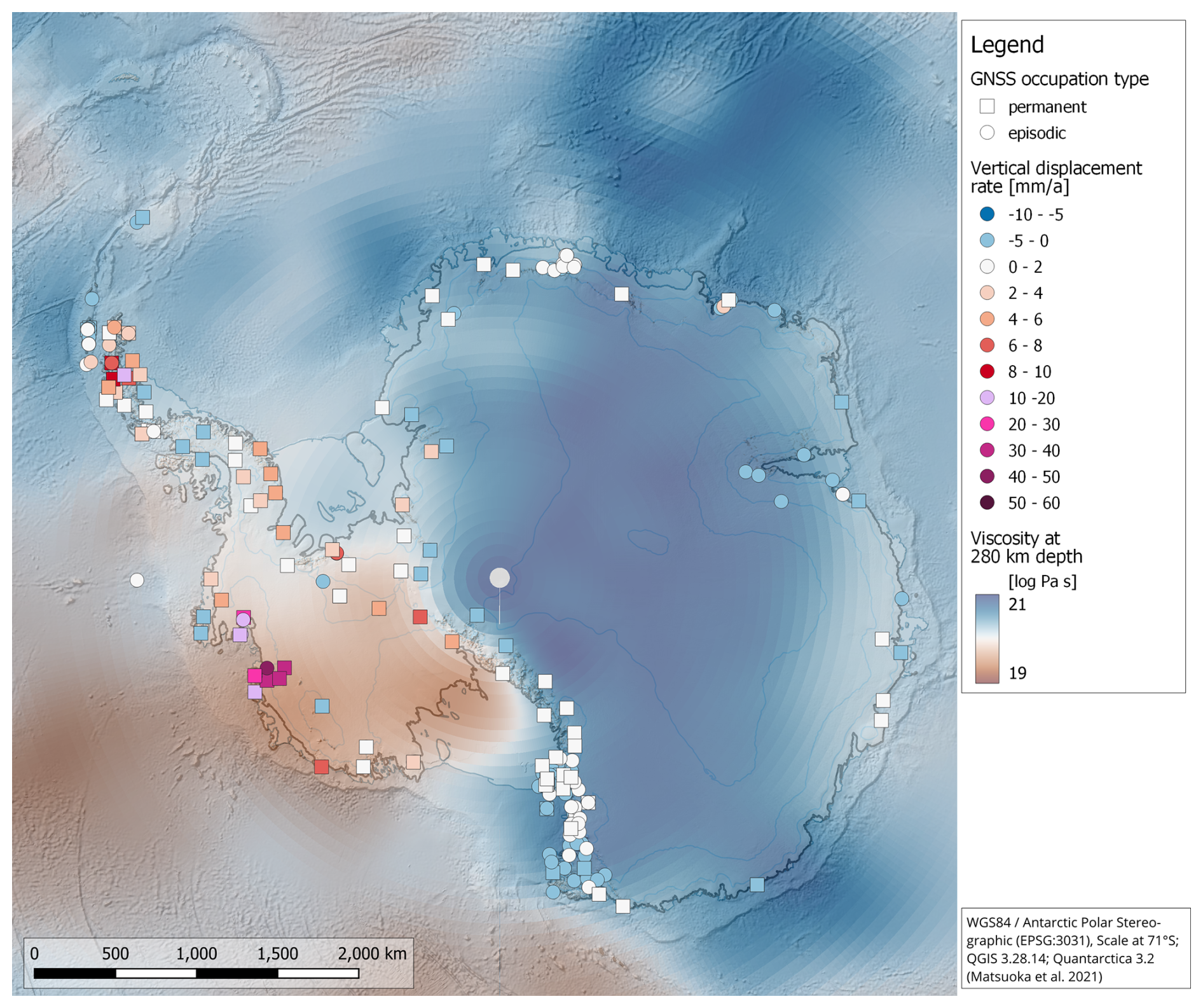
Figure 8GNSS-derived vertical displacement rates at sites that are part of the GIANT-REGAIN project (Buchta et al., 2025). These rates originate from preliminary analysis that includes a reduction for the immediate elastic effect, thus referring to GIA-induced uplift or subsidence. In the background, the upper mantle viscosity at 280 km depth is shown, predicted from a model by Bagge et al. (2021), which is based on seismic tomography. This model indicates a lateral variability of two orders of magnitude, with low viscosities beneath West Antarctica and high viscosities beneath East Antarctica. Low and high viscosities lead to shorter and longer GIA response times, respectively.
GNSS uplift rates have been used to provide evidence for low viscosity upper mantle beneath regions of West Antarctica and the Antarctic Peninsula (Fig. 8). The first evidence for substantially reduced upper mantle viscosities than those generally modeled emerged in the region of the Amundsen Sea Embayment (Groh et al., 2012; Busch et al., 2017; Barletta et al., 2018), with geodetic uplift rates that were higher than could be explained through elastic deformation alone (see Sect. 2.2.4). This finding is consistent with uplift rates assessed by other geodetic observation methods (Willen et al., 2025). Strong evidence for upper mantle viscosities of the order of 1018 Pa s was provided for the northern Antarctic Peninsula, where the onset of ice-mass loss following the collapse of the Larsen-B ice shelf changed uplift rates so dramatically that they could only be reproduced by modelling the uplift as a viscoelastic response to the ice loading changes (Nield et al., 2014). Subsequent studies have helped refine our understanding of upper mantle rheology in these regions (Zhao et al., 2017; Barletta et al., 2018; Samrat et al., 2020, 2021), including using a combination of satellite altimetry and tide gauge data (Rezvani et al., 2024), and in other regions of Antarctica (see Table 6 of Ivins et al., 2023b).
These geodetic and seismic constraints, in turn, led to new understanding of the importance and magnitude of the solid-Earth rapid braking effect on ice-sheet retreat (cf. Sect. 2.9), especially in the Amundsen Sea Embayment (Gomez et al., 2010; Adhikari et al., 2014; Konrad et al., 2015; Barletta et al., 2018; Larour et al., 2019; Kachuck et al., 2020; Gomez et al., 2024; Lucas et al., 2025; van Calcar et al., 2025). Spatial patterns of GPS uplift rates, combined with models of GIA, have also been used to infer unmodeled ice-sheet mass changes during the Late Holocene. These regions include the Weddell Sea sector (Bradley et al., 2015; Wolstencroft et al., 2015) and a portion of East Antarctica (King et al., 2022). Late Holocene retreat and readvance of the ice sheet is now an emerging research topic in paleo ice-sheet and GIA studies (e.g., Kingslake et al., 2018) (see also Sect. 3.1 and 3.2).
2.2.4 Short-period loading deformations
While many of the GNSS applications to the study of Earth deformation have focused on the response of the solid Earth to past surface loading changes, it is now clear that elastic deformations due to contemporaneous loading changes are non-negligible on a longer timescale. Notably, these include changes due to ice-flow dynamics and surface mass balance (SMB), such as those discovered by Tregoning et al. (2009) in Enderby Land, East Antarctica. Studies of viscous deformation using GNSS depend on calculating and removing elastic deformation due to contemporaneous loading changes from the total displacements measured by GNSS (e.g., Thomas et al., 2011a). These are largely due to ice dynamic variations, often from changes in ice-shelf buttressing, either in the Antarctic Peninsula or in the Amundsen Sea Embayment, but can also be governed by changes in SMB like in Dronning Maud Land. This is especially true for time series that span less than a few years, although large SMB variations also occur over longer periods (King and Watson, 2020). Koulali et al. (2022, 2025) and King et al. (2022) showed that variations in SMB, if not considered, would bias GNSS observations of vertical GIA by several millimeter per year. They showed that the misfit of a linear GIA-response model is reduced when GNSS time series were corrected for SMB-driven deformation. Furthermore, in regions where the mantle viscosity is low, such as the Antarctic Peninsula, large variations in SMB can promote both the usual elastic solid-Earth response and a short-term viscous response (Nield et al., 2025). Correcting for this additional viscous response can increase the GNSS-derived uplift rates by up to 1–3 mm a−1. However, such corrections depend greatly upon the SMB model employed. This highlights the importance of reducing the uncertainties of SMB models (Mottram et al., 2021) in computations of the elastic (and short-term viscoelastic) solid-Earth response. The role of extreme precipitation events, related to atmospheric rivers, may be particularly important in producing step-like changes in coordinate time series (Li et al., 2023).
2.2.5 Volcanic signals
GNSS has also been applied to detect volcanic signals in Antarctica (e.g., Grapenthin et al., 2022), leading to an improved understanding of active volcanic processes within the tectonic landscape. For example, GNSS stations that are part of the large Victoria Land Network for DEFormation control (VLNDEF) confirm activity at Mt. Melbourne volcano and identify active tectonics at two main lineaments (Zanutta et al., 2017, 2018) as well as a residual clockwise rotation of the Victoria Land block relative to East Antarctica (Zanutta et al., 2020). Poli et al. (2021) attributed a swarm of tens of thousands of earthquakes in the Bransfield Basin to a volcanic origin based on geodetic observations from nearby GNSS data acquisition stations. Long-term, uninterrupted GNSS data collection enables surface deformation assessment in Antarctic regions known to have high volcanic activity (Berrocoso et al., 2012). Denoising GNSS time series using independent component analysis and spatiotemporal filtering offers the potential to detect subtle geophysical signals (Li et al., 2019). As the quantity of available data increases, the potential use of more powerful statistical methods can be realised. For example, machine learning approaches, including symbolic regression, convolutional neural networks, Gaussian processes, and transfer learning, may be applied to these time series. Recent work at Mt. Erebus volcano has used GNSS data from Ross Island, which was recorded, in part, by seven continuous sites that have operated since the 1990s. These data have allowed for a complete geodetic analysis of the open-vent volcanic system, suggesting that the long-wavelength subsidence at Mt. Erebus can be partly attributed to the growth and corresponding crustal loading of the volcano (Grapenthin et al., 2022).
2.2.6 Other physical and geophysical effects
In addition to solid-Earth deformation, GNSS sites on bedrock are sensitive to the ground surface and atmospheric conditions around the antenna; notably, multi-path signals reflected from the changing snow surface elevation, tropospheric water vapor, and ionospheric total electron content. Early work (e.g., Thomas et al., 2011b; Negusini et al., 2016) demonstrated the ability of long-running Antarctic GNSS observations to retrieve in-situ tropospheric water vapor without the need for manual radiosonde launches (cf. Sect. 2.10). A further challenge is that tropospheric conditions may lead to the seasonal build-up and melting of ice within the antenna radome if it is not sealed to prevent the ingress of wind-driven snow (Argus et al., 2014; Konfal et al., 2016). This, in turn, may introduce an apparent seasonal change of up to a few mm in measured vertical position, thus corrupting model inferences of solid-Earth load response (Koulali and Clarke, 2020). Identification and removal of such artifacts in the data rely on the existence of continuous or nearly-continuous observational time series spanning several years.
2.2.7 Ice-surface height and sea-level variations
As discussed in Sect. 2.2.3, GIA is closely interlinked to regional sea-level change as well as to SMB variations that may impact long-term bedrock displacement rates. However, in-situ data on regional sea-level change are sparse, as provided by tide gauge installations around Antarctica (e.g., Galassi and Spada, 2017); cf. Fig. 2.3. Here, GNSS interferometric reflectometry (GNSS-IR) offers a different technique that allows for the observation of regional sea level and of several other phenomena. GNSS-IR is a low-cost remote sensing technique that relies on signals of opportunity, and it only requires lightweight, low-power receiver-only systems. The technique can also be applied to data from existing continuous GNSS stations along coastlines. Depending on the application, the antenna can be mounted on bedrock or at the ice surface.
The concept of scattering, which forms the basis for GNSS-IR, was introduced by Hall and Cordey (1988) through the use of multi-static principles, thereby laying the groundwork for the development of the Passive Reflectometry and Interferometry System (PARIS) by Martín-Neira (1993). Based on the knowledge of scattering GNSS signals, GNSS-IR has become a promising complement to retrieve surface-height variations (e.g., Larson and Williams, 2023), which are estimated from the signal-to-noise ratio of the data from a single GNSS receiver. In Antarctica, numerous GNSS-IR studies have been conducted over the last decade to monitor how sea- and ice-level variations over several years depend on climate system evolution (Peng et al., 2021; Nievinski and Larson, 2014a, b). The analysis and interpretation of scattered signals holds the potential to provide a variety of insights. These include the detection of current sea level, deriving properties of the topmost and uppermost layers due to the reflection of GNSS carrier waves that penetrate into the ice body, and to monitoring ocean wind and waves (Cartwright et al., 2019; Rius et al., 2017; Selbesoğlu, 2023; Simeonov et al., 2021; Tabibi et al., 2020).
For sea-level monitoring, GNSS-IR offers significant advantages relative to tide gauges since the reflected and direct signals can be obtained with only one GNSS receiver which also measures the vertical land motion (Peng et al., 2021). Geremia-Nievinski et al. (2020) investigated the accuracy of GNSS-IR for sea-level monitoring using data from eight POLENET GNSS stations in Antarctica and demonstrated that the GNSS-IR approach could estimate sea level at a level compatible with a conventional tide gauge, with a correlation coefficient of 0.90. Additionally, Selbesoğlu (2023) examined one year of data from the Palmer Station GNSS site and found a correlation of 0.91 between GNSS-IR and conventional tide-gauge sea-level measurements. Consequently, GNSS-IR holds the promise of bridging the observational gap in sea-level monitoring within coastal zones in Antarctica over a broad swath near the coastline (up to 0.5 km), thereby surpassing the capabilities of traditional tide gauges (Peng et al., 2021; Santamaría-Gómez et al., 2012). However, challenges remain in identifying and removing the effects of sea ice.
2.3 Tide Gauges
Until the arrival of GNSS-IR, tide gauge observations offered the unique opportunity to measure the motion of bedrock relative to the local sea surface. In Antarctica, such measurements are provided by conventional gauges, measuring sea-surface height, and bottom pressure recorders. The latter require a correction for steric effects to recover sea surface height. Bottom pressure recorders are also often subject to instrument drift, although self-calibrating bottom pressure gauges exist (e.g., Cook et al., 2023). Nonetheless, such data are critical in testing ocean tide models (Sun et al., 2022; Padman et al., 2018; King et al., 2011, 2005).
Solid Earth applications of Antarctic tide gauge data have been hampered by the very few long records. Galassi and Spada (2017) show only two gauges spanning more than three decades up to 2013. Nonetheless, they reconstructed sea-level change in the Antarctic Peninsula and the Ross Sea region of West Antarctica and inferred evidence of reduced sea-level rise due to increased ice-sheet melt. Rezvani et al. (2024) combined tide gauge with altimetry data from the Antarctic Peninsula and estimated non-linear vertical land motion due to ice-loading changes, and used these to revise the viscoelastic model of Nield et al. (2014). In this case, the tide gauges and altimetry data, spanning back to 1992, together provide new constraints on deformation before the 2002 onset of unloading following the Larsen B Ice Shelf collapse that was previously only captured by a small handful of GPS stations.
2.4 Seismology
The seismic wavefield in Antarctica is a composite signal arising from tectonic, cryospheric, ocean, and atmospheric sources that is unique on Earth. Seismology was included in one of the first scientific expeditions to the continent (1901–1904; Milne, 1905); however, the collection of seismic data proceeded slowly through the 20th and early 21st century due to the harsh environmental and logistical conditions. Today, there are just a few continuously recording seismic stations on the continent that have operated for more than 20 years, mostly located at or in the vicinity of coastal science bases, with just two stations operating in the deep interior (at Amundsen-Scott Station, South Pole, and at Concordia Station, Dome C) (cf. Figs. 5 and 6). Integrated into global seismographic networks (e.g., Global Seismographic Network (GSN), GEOSCOPE, GEOFON), such long-running stations provide high-quality, near real-time data (e.g., Anthony et al., 2021; Ringler et al., 2022). Despite their limited numbers, these stations have proved critical to global-scale Earth tomography as well as to imaging geophysically imaging plate-scale structure of the Antarctic Plate. Data from long-operational stations, integrated with limited duration seismic deployments, provide information on a wide range of seismic sources as well as robust observations of secular and seasonal changes in ice and ocean waves encoded within the seismic background signal (Anthony et al., 2015, 2017; Pratt et al., 2017; Aster et al., 2023; Becker et al., 2026).
Seismic studies in Antarctica's interior using portable digital stations started with six temporary broadband stations from the 1998–2001 ANUBIS project (Anandakrishnan et al., 2000), which, though limited to summer operation, spurred progress in improved power and data storage. The 2000–2003 TAMSEIS project expanded to 46 stations (e.g., Lawrence et al., 2006), and year-round operation was achieved through GAMSEIS and POLENET/ANET using low-power instruments, dual power systems, Iridium telemetry, and specially engineered enclosures (e.g., Hansen et al., 2009; Chaput et al., 2014). These innovations enabled deployments across the continent, providing records for a few years each, or in the case of POLENET/ANET, for over 15 years. Growing coverage eventually led to over 200 non-contemporaneous sites, which helped to produce models with tenfold improvements in crustal and mantle resolution, thereby clarifying tectonics, geodynamics, and Earth–cryosphere interactions (Fig. 9; Wiens et al., 2023). More recently, high-rate data from isolated stations (Chaput et al., 2018, 2022), nodal arrays (e.g., Zhang et al., 2024), and distributed acoustic sensors (DAS) (e.g., Yang et al., 2024; Fichtner et al., 2025) have extended cryoseismological studies to the firn and ice-column scale.
Pioneering seismic investigations since the late 1970s revealed distinct features of Antarctica, including: (1) the dichotomy of the seismic structure between West and East Antarctica; (e.g., Knopoff and Vane, 1978; Ritzwoller et al., 2001; Danesi and Morelli, 2001; Sieminski et al., 2003); (2) an absence or reduced level of tectonic seismicity throughout the continent (Reading, 2006; Peña Castro et al., 2024), which is partially attributable to the sparsity of the observational networks; and (3) seismic signals related to cryospheric dynamics (Martin et al., 2010; Pirli et al., 2015; Guerin et al., 2021; Wiens et al., 2024) and Antarctica's environment (Aster et al., 2010; Grob et al., 2011; Anthony et al., 2017; Pratt et al., 2017). Both structural and source studies provide unique contributions to understanding the glacially obscured geologic and tectonic structure, the stress state of the continent, the interconnected processes between the solid Earth, the oceans, and the ice sheet, as well as the structure, dynamics, and evolution of the cryosphere. These and many other discoveries provide strong motivation for greater and sustained Antarctic seismic network coverage. In the following subsections, we summarise the results stemming from 21st century Antarctic seismic initiatives.
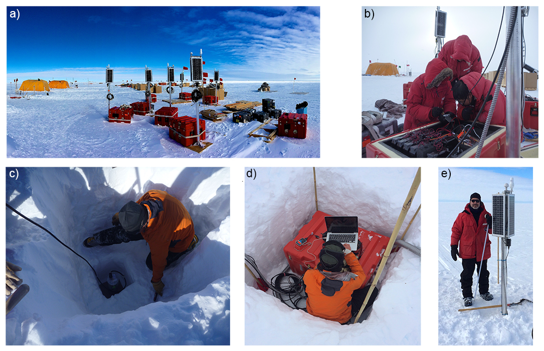
Figure 9Example deployment of two-year continuously recording, autonomous broadband seismic stations on the Ross Ice Shelf during the RIS/DRIS experiment (Bromirski et al., 2015). (a) Stations in transport configuration, showing solar/communications assemblies and data acquisition systems in ultra-insulated field cases. Up to three such stations in this configuration can be transported simultaneously by Twin Otter aircraft. (b) Field installation of primary lithium-thionyl-chloride batteries for continuous winter (dark) operation. (c) Firn installation and orientation of a Nanometrics Trillium 120 posthole broadband seismometer. (d) Installation and field check of data acquisition system. (e) Following installation, the solar/communications mast assembly of solar panels, GPS, and Iridium satellite state-of-health antennas is the sole component remaining above the snow surface.
2.4.1 Advancements in Seismic Structure: Crust and Upper Mantle
Shallow structures, including sedimentary layers and the crystalline crust, provide rich information about the geological history of continents. Particularly, sedimentary rocks in Antarctica, their distribution beneath the AIS, in combination with the presence of liquid water, determine the frictional and rate-state sliding properties along the ice-sheet basal interface, thus critically influencing ice-flow dynamics (Berdahl et al., 2023). The properties of sediment (e.g., mechanical and thermal properties, pore volume) differ considerably from more consolidated strata and basement crystalline crust; therefore, knowledge of sediment spatial distribution and thickness is important to correctly determine future ice-sheet behavior. Due to the thick ice coverage, many of the sedimentary basins beneath the AIS are still not robustly delineated. In a recent review, Aitken et al. (2023) provided a comprehensive summary of measurement techniques (including passive and active source seismology and potential field methods) to determine the presence of sediments beneath the ice.
Crustal thickness across Antarctica reflects its tectonic evolution, marked by a sharp contrast between West and East Antarctica (Cande et al., 2000; Reading et al., 2022). Moho depth has been mapped using seismic tomography (An et al., 2015; Heeszel et al., 2013), receiver functions (e.g., Hansen et al., 2010; Chaput et al., 2014; Ramirez et al., 2016; Hansen et al., 2016), and joint inversions (Bayer et al., 2009; Shen et al., 2018; Baranov et al., 2021). West Antarctica, assembled along Gondwana's southern margin, includes contrasting provinces: relatively thicker crust beneath the Antarctic Peninsula (∼34 km) and Marie Byrd Land (∼28 km) and thinner crust under the Ronne Ice Shelf side of the Transantarcic Mountains (less than 20 km) (Jordan et al., 2020; Shen et al., 2018). In contrast, East Antarctica is underlain by ancient cratons, with crustal thickness ranging from more than 55 km beneath the Gamburtsev Subglacial Mountains to less than 20 km under the Lambert Rift. Intermediate crustal thickness values are found beneath Dronning Maud Land (∼45 km) (Bayer et al., 2009), while beneath the Wilkes and Aurora Subglacial Basins, crustal thickness estimates are more varied, ranging from ∼25 to ∼40 km (Baranov and Morelli, 2013; Hansen et al., 2016; Shen et al., 2018; Li and Aitken, 2024).
Antarctic upper mantle structure has been traditionally inferred by regional studies, but since the mid-2010s, it has often been constrained using integrated datasets from these regional deployments. Various tomographic techniques have been used, including Rayleigh wave inversions from earthquakes and ambient noise; (e.g., An et al., 2015; Shen et al., 2018), P wave travel-time delays (e.g., Hansen et al., 2020), and full waveform inversion (Fig. 10; Lloyd et al., 2020; Hansen and Emry, 2025). The resulting images reveal a highly heterogeneous upper mantle, reflecting diverse geodynamic processes. West Antarctica features include a possibly disrupted mantle plume beneath Marie Byrd Land, fragments of the subducted Phoenix plate and slab window, heterogeneity reflecting Cenozoic and recent extension (Lloyd et al., 2015), localised low-velocity zones beneath young volcanism, and processes along the Transantarctic Mountains, including lithospheric delamination (Heeszel et al., 2013; Shen et al., 2017; Seroussi et al., 2017) and thermal loading and flexure (Brenn et al., 2017). East Antarctica shows fast, thick Archean to Proterozoic lithosphere centrally, variable structure in Dronning Maud Land, and thinner lithosphere along the coast and beneath the Lambert Graben as well as beneath the Wilkes and Aurora Subglacial Basins (Lloyd et al., 2020; Chua and Lebedev, 2025; Hansen and Emry, 2025; Heeszel et al., 2013). These advances reveal lithospheric structure and geodynamic processes that influence GIA, sea level, and the ice sheet (Gomez et al., 2024).
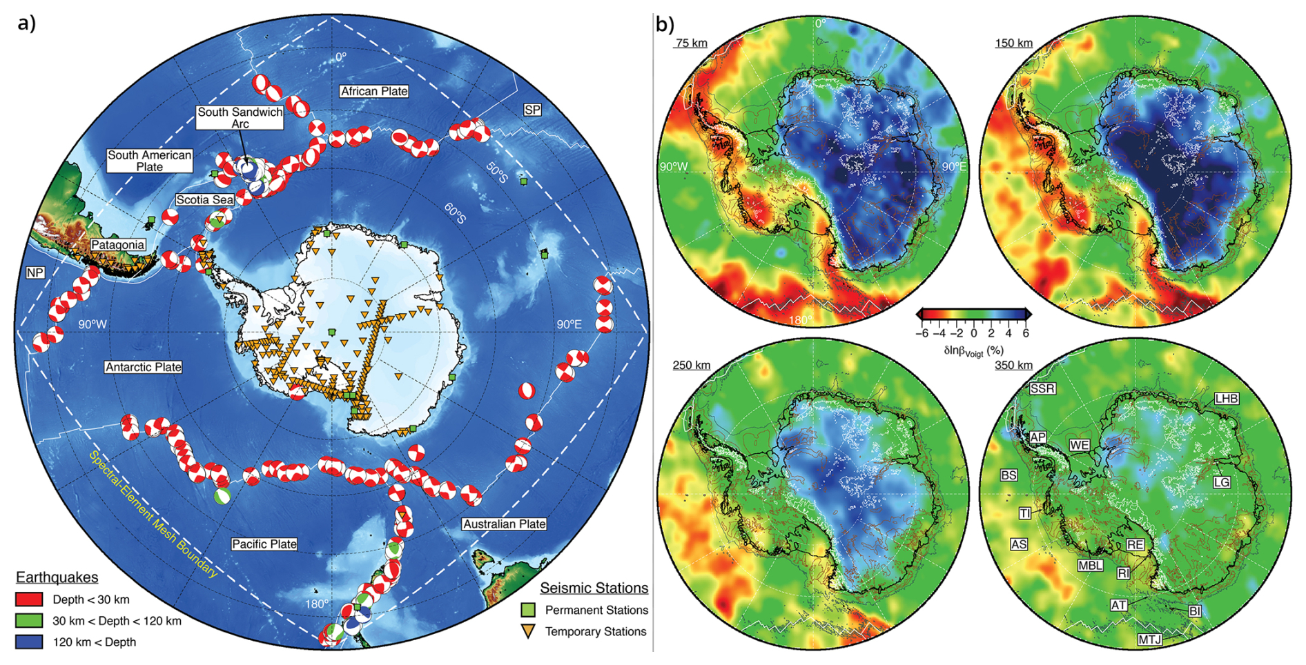
Figure 10Full-waveform inversion model (ANT-20) for the Antarctic plate constrained by body and surface waves with periods from 15 to 150 s recorded by permanent and temporary seismic stations. (a) Earthquake sources and stations. (b) Voigt average shear‐wave speed structure at 75, 150, 250, and 350 km depths. Abbreviations: AT: Adare Trough, AS: Amundsen Sea, AP: Antarctic Peninsula, BI: Balleny Islands, BS: Bellingshausen Sea, LG: Lambert Graben, LHB: Lützow‐Holm Bay, MTJ: Macquarie Triple Junction, MBL: Marie Byrd Land, RE: Ross Embayment, RI: Ross Island, SSR: South Scotia Ridge, TI: Thurston Island, WE: Weddell Embayment. Adapted from Lloyd et al. (2020).
2.4.2 Advancements in Seismic Structure, Mantle Transition Zone and the Deep Earth
The mantle transition zone (MTZ), marked by seismic discontinuities near 410 and 660 km depth, varies in thickness with temperature and pressure, making it a useful probe of mantle conditions (Bina and Helffrich, 1994). Since the 2000s, only a limited number of studies has targeted the MTZ structure beneath Antarctica. Receiver function analyses, often used to map MTZ topography (Langston, 1979; Shearer, 1991), reveal a slow anomaly above the MTZ in East Antarctica (Vinnik and Farra, 2007), a deepened MTZ base (∼720 km) beneath Mt. Erebus, consistent with anomalously high temperature mantle, and uniform MTZ thickness beneath Ross Island (Andrews and Deuss, 2008), suggesting that most anomalies are confined to the upper mantle (shallower than ∼660 km). Later work (Reusch et al., 2008; Emry et al., 2020) found MTZ thinning beneath the Transantarctic Mountains, possibly linked to a deep-seated plume, while the MTZ beneath West Antarctica generally shows average thickness with localised thinning near Marie Byrd Land and the Bentley Subglacial Trench, possibly due to hot lower-mantle upwelling (Emry et al., 2015).
Lower mantle and core structure beneath Antarctica remain poorly resolved, but Antarctic stations provide unique high-latitude ray paths that sample the Earth's deep interior. Seismic investigations that incorporate such data are critical to determining the viscosity of the lower mantle, which strongly influences GIA as well as deep Earth convection. For example, recent work by Bellas-Manley et al. (2026) illustrates that relative sea-level observations and GNSS-determined uplift rates are fit about 40 % better by Earth models that incorporate 3D laterally variable viscosity, estimated from seismic tomography. A key aspect of this model and a 3D tomography GIA study of the time-varying gravity field by Hightower et al. (2026) is that the lower mantle viscosity is about 30 times greater than that in the upper mantle.
Seismic investigations based on Antarctic datasets have also revealed exciting details about our planet's deep interior structure. For example, lower-mantle scatterers (e.g., Ma et al., 2016) and widespread slow anomalies along the core–mantle boundary (Hansen et al., 2020, 2023; Agboola et al., 2024) have been interpreted to represent ancient subducted materials. Core phases sampled near the Earth's rotation axis support the idea of inner-core super-rotation (Song and Li, 2000), providing additional insights about core structure, anisotropy, and dynamics (Tromp, 2001; Wang et al., 2024). Additionally, Antarctic data have shown increasing inner-core inhomogeneity with depth, offering clues to its growth history (Peng et al., 2021).
2.4.3 Advancements in Understanding Antarctic Seismic Sources
Antarctica was long thought to be mostly aseismic. The installation of GSN stations in the mid-1990s revealed intraplate earthquakes, including clusters in the Transantarctic Mountains and the continental interior (Reading, 2007). Regional networks, including the long-running Mt. Erebus networks, have detected widespread volcanic (Rowe et al., 1998, 2000; Zandomeneghi et al., 2013; Knox et al., 2018) and non-volcanic activity (Peña Castro et al., 2024), while smaller deployments have identified seismicity in the West Antarctic Rift System and events near Lützow-Holm Bay, some linked to deglaciation. Later arrays, including TAMSEIS, GAMSEIS, and POLENET/ANET, have greatly expanded geographic coverage, uncovering examples of tectonic activity (Winberry and Anandakrishnan, 2003). These findings include magmatic earthquake swarms in Marie Byrd Land (Lough et al., 2013), extensional events near the Gamburtsev Subglacial Mountains (Lough et al., 2018), the Mw 8.1 Balleny Islands earthquake (possibly GIA-related, Ivins et al., 2003; Himeno et al., 2011), and a massive swarm of about 85 000 events in the Bransfield Strait tied to dike intrusion (Cesca et al., 2022). Despite these advances, sparse station coverage still limits understanding of Antarctic intraplate stress, deformation, and cryosphere dynamics. These examples demonstrate that Antarctic seismicity cannot be treated as a single source class. Instead, tectonic, volcanic, glacial, hydrologic, ocean-forced, and anthropogenic signals may overlap in time and frequency content, especially where sparse station coverage limits source discrimination. Sustained regional networks and denser temporary deployments are, therefore, essential not only for detecting small events, but also for distinguishing source mechanisms and linking seismic observations to solid-Earth, cryospheric, and oceanic processes.
Antarctic seismic records contain abundant cryospheric signals and have helped drive advances in cryoseismology (Fig. 11; Podolskiy and Walter, 2016; Aster and Winberry, 2017). Impulsive sources include regions of prolific ice fracture and basal stick-slip, while non-impulsive signals arise from oceanic and atmospheric forcing. Glacial seismicity near grounding lines is highly sensitive to tides and swells. For instance, the Whillans Ice Stream exhibits quasi-characteristic, tidally triggered stick-slip at ∼ Mw 7 scale (Wiens et al., 2008, 2024). Ice shelves also generate strong seismic signals from gravity-flexural waves and slip at grounding zones (Bromirski et al., 2015, 2017; Aster et al., 2021). Additional signals stem from calving, englacial fracturing, and interactions with ocean waves and tsunamis (Fig. 11). Drifting and colliding icebergs produce seismic and seismoacoustic waves that propagate thousands of kilometers, shaping the Southern Ocean soundscape. Iceberg seismicity includes tremor lasting hours, generated by ice-ice or ice-seafloor collisions (MacAyeal et al., 2008; Martin et al., 2010). The extensive Antarctic sub-glacial meltwater system further modulates bed friction and produces englacial and subglacial hydrologic signals.
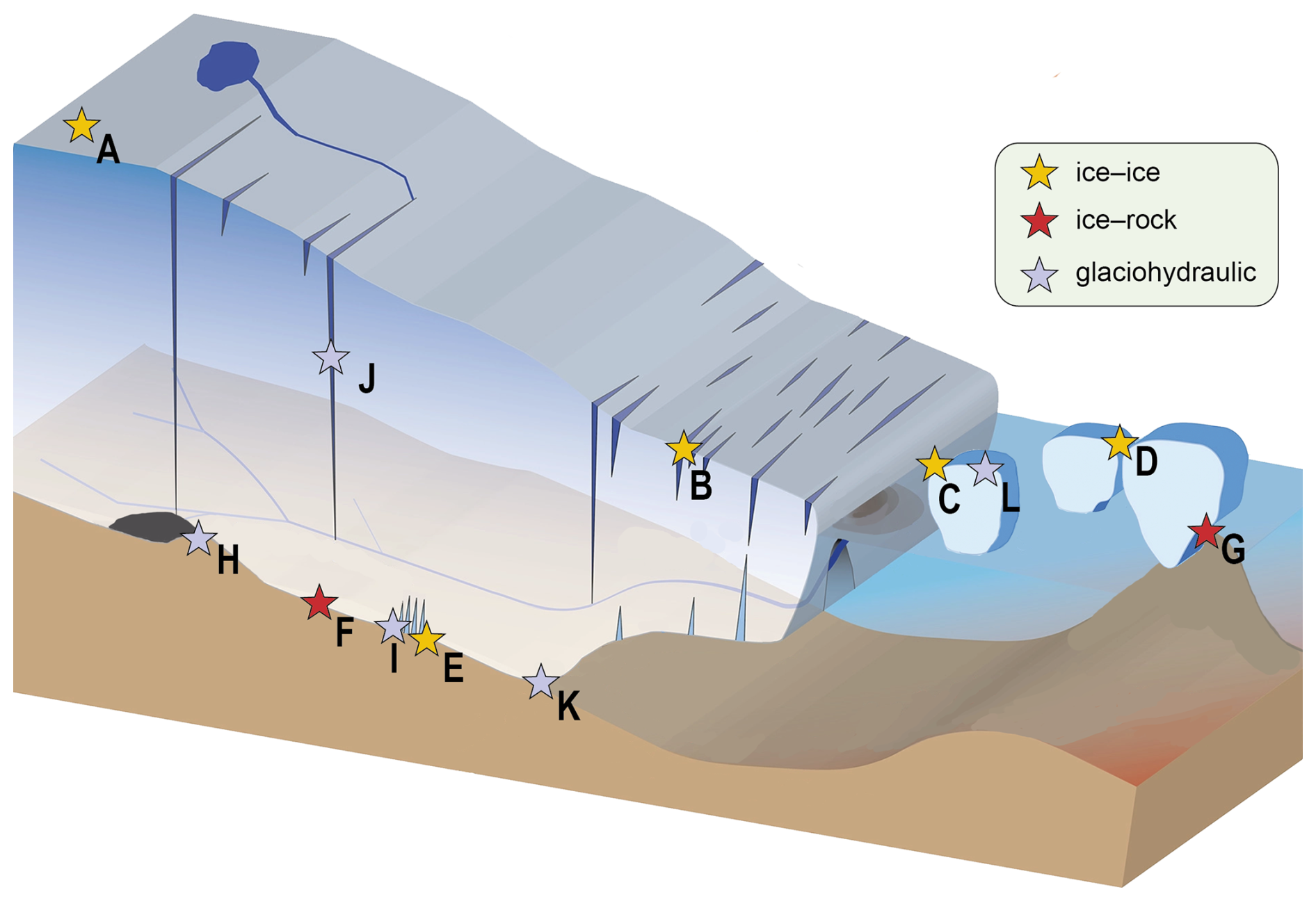
Figure 11A summary of Antarctic cryoseismic source types (stars) with a high degree of vertical exaggeration. (A–E) Ice–ice dynamic processes; (A) Ice-sheet icequakes and firnquakes; (B) Surface crevasse opening or collapse; (C) Calving; (D) Iceberg–iceberg collision, rifting, and fracture; (E) Basal crevasse opening or collapse; (F) Glacial basal stick-slip; (G) Iceberg grounding stick-slip; (H–L) Ice-water interactions; (H) Subglacial lake drainage and water transport; (I) Basal crevasse water transport and resonance; (J) Moulin water transport and tremor; (K) Terminus discharge; (L) Iceberg/calving impact and water column sources. Modified from Aster and Winberry (2017) using a figure from Catania et al. (2020).
Much of the Antarctic glacial system exhibits velocity strengthening stick-slip behavior and thus slides without detectable seismicity. However, prolific basal seismicity is observed at specific glacial beds having both rapid (e.g., Zoet et al., 2012; Danesi et al., 2007; Hudson et al., 2023) and slow (e.g., Lipovsky and Dunham, 2017; Barcheck et al., 2021) time-scales. This includes basal tremor, interpreted as a superposition of small stick-slip events (Winberry et al., 2013; Podolskiy et al., 2021; Barcheck et al., 2021). Understanding basal stick-slip and general basal rheology is fundamental to glacial dynamics and cryoseismology (e.g., Tsai et al., 2017; Zoet and Iverson, 2020; Gilbert et al., 2023).
Antarctic ambient seismic noise originates primarily from the atmosphere and oceans. Large-scale ocean noise intensity is controlled by gravity wave energy in the Southern Ocean and damping by seasonally varying sea ice (Grob et al., 2011; Anthony et al., 2015; Aster and Winberry, 2017; Pratt et al., 2017). Swell and infragravity waves propagating from storm centers (e.g., MacAyeal et al., 2006; Cathles et al., 2009) generate the large-scale microseism wavefield (4–20 s periods) (Anthony et al., 2015; Pratt et al., 2017) via two mechanisms: (1) Shallow direct ocean swell tractions on the seafloor as the primary mechanism; (2) Forces generated by standing wave components from interfering ocean waves as the secondary mechanism (e.g., Ardhuin et al., 2015). Ambient microseism noise is widely used, often jointly with earthquake data, for Earth imaging from the crust to the upper mantle (e.g., Shen et al., 2018) (cf. Sect. 2.4.1).
Finally, high-frequency ambient noise (>10 Hz) originates from wind, short-period ocean waves, and anthropogenic sources. This wavefield is used to image firn, ice/water column thickness, and basal sediment (e.g., Zhan et al., 2013; Diez et al., 2016; Aster et al., 2021; Chaput et al., 2022). Characterising wind noise is also key for assessing detectability of other signals (e.g., Anthony et al., 2015; Frankinet et al., 2021; Zhou et al., 2022). Temporal variations in ambient noise are effective for studying cryospheric, oceanic, and hydrological changes. For example, microseism intensity correlates with the southern annular mode and seasonal sea ice extent (e.g., Aster et al., 2008; Anthony et al., 2017; Pratt et al., 2017; Aster et al., 2023), while changes in cryospheric noise and icequake activity constrain dynamic processes like melt/refreezing (e.g., MacAyeal et al., 2018; Chaput et al., 2018, 2023), basal processes affecting ice-stream stability (e.g., Guerin et al., 2021), and permafrost thaw (e.g., James et al., 2019).
2.5 Gravimetry and magnetometry
Gravimetric and magnetic data can be collected on the ground which, however, require considerable logistical effort for remote regions to cover even small areas relative to the size of the Antarctic continent. Therefore, geopotential data were acquired mostly by airborne surveys. Ground-based gravity surveys can still be regarded an exception, although respective surveys have been conducted also recently, confined to specific target areas (e.g., Lösing et al., 2026). Even if airborne surveys are not in the focus of this review paper, we will give a concise summary of recent achievements gained regarding the geopotential fields.
With regard to the gravity field, considerable efforts have been made in the last three decades in collecting and compiling airborne, ground-based and shipborne gravimetric data for the Antarctic continent and its adjacent oceanic areas. The AntGG compilation (Scheinert et al., 2016) covers 73 % of Antarctica with a 10 km resolution grid and provides datasets for free-air and Bouguer gravity anomaly. Notable updates include the transition to a fully covered 5 km grid, the inclusion of latest gravity surveys and an improved processing (Zingerle et al., 2019, 2021). This processing was based on the usage of the so-called disturbing potential and the application of the least-squares collocation which enabled to calculate uncertainty measures for the gravity anomaly to be predicted. Thus, beside the free-air anomaly and Bouguer anomaly, further datasets could be provided consistently inferred from the disturbing potential such as height anomaly (which equals geoid height in the ocean area) and the second derivative of the potential (Scheinert et al., 2024). This recent Antarctic gravity anomaly solution was, for instance, used in determining by inversion subglacial and ocean-bottom topography, respectively (Charrassin et al., 2025).
Furthermore, pointwise measurements using an absolute gravity meter open additional applications, although absolute gravimetry in Antarctica has to be regarded still a special case. On the one hand, absolute gravity points serve as a reference for relative gravimetry campaigns (both land-based and airborne) (Mäkinen et al., 2007). On the other hand, repeated absolute gravity measurements at identical bedrock locations offer the possibility to infer gravity changes, which can be combined with height changes inferred from co-located GNSS, providing additional information on ice-mass change and associated crustal deformation and GIA (Amalvict et al., 2009; Näränen et al., 2025).
With regard to the magnetic field, Antarctica is covered by a wealth of aeromagnetic surveys (e.g., Frémand et al., 2022). The first Antarctic magnetic anomaly compilation (ADMAP-1) was produced in 2001 from more than 1.5 million line-km of shipborne and airborne measurements (Golynsky et al., 2006), succeeded in 2018 by the second-generation Antarctic magnetic anomaly compilation (ADMAP-2) now including more than 3.5 million line-km of aeromagnetic and marine magnetic data that more than doubles the initial near-surface database (Golynsky et al., 2018).
Data gaps nonetheless exist wherein satellite data provide supplementary information, albeit with lower resolution than that of the airborne compilations. This is shown in Fig. 12, where aeromagnetic data were conformed to satellite data. Satellite data provide the long-wavelength foundation to improve the consistency of data that originates from different continents with shorter wavelength features being captured by aeromagnetic surveys. Such complementary satellite datasets offer wide-area coverage and consistent resolution (e.g., Lu et al., 2020; Ebbing et al., 2021). Continent-wide constraints on tectonic structure have been derived using satellite and airborne data (Ebbing et al., 2018, 2021). For example, aeromagnetic anomalies shown in the context of a plate tectonic reconstruction can be tracked across continental margins of Australia, India, Africa, and into East Antarctica (Fig. 12). The continuation of anomalies between former neighbours in Gondwana reinforces the evidence for a shared tectonic history.
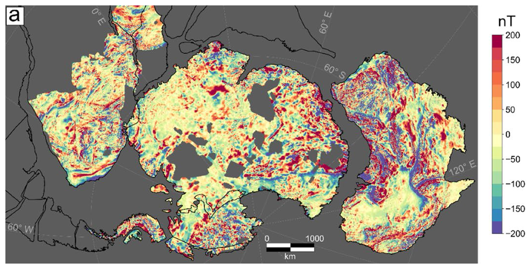
Figure 12Magnetic data compilation, where airborne datasets (e.g., Golynsky et al., 2018) were conformed to a satellite model (LCS-1, Olsen et al., 2017) using an equivalent layer approach and were superposed on a deformable Gondwana plate reconstruction. From Ebbing et al. (2021).
On a regional scale, aeromagnetic constraints employed with multidisciplinary data have been used to map the structure across Dronning Maud Land (Ruppel et al., 2018). Interpretation of magnetic anomalies in this example study suggests a significant area of East Antarctic crust is composed of either accreted oceanic arc terranes or major shear zones of Pan-African origin. Aeromagnetic and gravity variations have also helped to constrain the sub-ice tectonic structure beneath Wilkes Land, Terre Adelié, and surrounding regions using variation of information joint inversions (Lowe et al., 2024). This has revealed, for example, large batholiths and other intrusive structures in East Antarctica. Joint interpretation of gravity and magnetic anomalies has thus proven valuable as a means to discriminate between subsurface density and compositional variations.
More details about the characteristics of gravity and magnetic data sets can be found in Pappa and Ebbing (2023) and with focus on applications in the ocean-continent transition zone in Matsuoka et al. (2026), and in Sect. 2.8.
2.6 Magnetotellurics
Magnetotelluric (MT) methods enable conductivity (or its reciprocal, resistivity) structure and anomalies to be inferred from the natural variations in the Earth's electric and magnetic fields that arise from variations in the solar wind impinging on the planetary magnetosphere. Such passive MT surveys have the capability to resolve structures from tens of meters to several hundred kilometers below the Earth surface (Chave and Jones, 2012). The MT technique is increasing in use for solid Earth and ice-bedrock interface zone investigations in the polar regions, together with other electromagnetic methods (Hill, 2020). Long-period MT station deployments of approximately three weeks yield information about heterogeneities in the asthenosphere and deep lithosphere, notably providing information pertaining to viscosity and dynamics (Lijun and Hasterok, 2016). Viscosity estimation can be improved if both MT and seismic data are available (Ramirez et al., 2022). Information relevant to the Antarctic upper mantle thermal regime and hydration state has also been inferred from such data (Wannamaker et al., 2023). Broadband MT station deployments of 5 to 8 d can be used to infer conductivity anomalies indicative of shallow crust (Peacock and Selway, 2016), subglacial and glacial processes, such as saline incursions of sea water in the ice-bedrock interface zone (Manassero et al., 2026). It has high potential for use in multidisciplinary groundwater studies (Siegert et al., 2018; Gustafson et al., 2022), with recent broadband instrumentation potentially enabling co-located mantle investigations if stations are deployed over at least three weeks.
2.7 Heat Flow Direct Determinations
Geothermal heat flow combines influences from the deep Earth's primordial heat, radioactive decay, vertical advective upper mantle flow and heat producing elements in the Earth's crust. It is indicative of tectonic setting, potentially providing insights to the solid Earth at a given location, provided any volcanic and hydrothermal influences are properly accounted for (Jaupart and Mareschal, 2015). In Antarctica, geothermal heat influences ice sheet temperature and, hence, its internal deformation, controls frictional sliding (McCarthy et al., 2017) and the likelihood of subglacial melt (Seroussi et al., 2017). The determination of geothermal heat flow in Antarctica has been previously reviewed by Burton-Johnson et al. (2020). Direct borehole measurements are small in number and sparsely distributed across Antarctica (Talalay et al., 2020, 2026). Locally high values (Begeman et al., 2017) need to be appraised with understanding of their regional context (Reading et al., 2022). Recent direct determinations such as those at Law Dome and Princess Elizabeth Land (Mony et al., 2020; Talalay et al., 2023) have been augmented by improved understanding of the influence of the heat production (Stål et al., 2024; Hazzard and Richards, 2024), and studies based on geological constraints (e.g., Arora et al., 2026), multi-variate inputs (Lösing et al., 2025), and airborne geophysics (Kerr et al., 2026). Further consideration of geothermal heat flow as a boundary condition for subglacial hydrology, basal thermal state, and ice-sheet dynamics is given in the context of the ice-bedrock interface zone in Sect. 2.8.2.
2.8 Multidisciplinary Studies
Multidisciplinary studies offer a further, powerful means to address many scientific questions relating to the solid-Earth structure beneath Antarctica, and are defined as studies where two or more observables (such as magnetic anomalies and seismic velocities) or knowledge synthesis frameworks (such as plate tectonic reconstructions) are combined. Examples of such studies use combined airborne data, petrological and geophysical approaches, joint forward and inverse modelling, and statistical and machine learning approaches. The multivariate toolbox has rapidly expanded in recent years given improved dataset compilations, open-access data sharing (cf. Sect. 3.4), and computation capabilities. Many such techniques require a considered approach to combining multiple datasets. As an illustration, oceanic crust, ultramafic, mafic, intermediate igneous rocks, and sedimentary units that include these lithologies typically give rise to high-amplitude gravity anomalies and pronounced large magnetic anomalies. Density values for rock-forming minerals vary over a narrow range (Telford et al., 1991), generally within a factor of less than two (2.3–4.0 g cm−3), whereas magnetic susceptibility varies over many orders of magnitude (0– SI). Magnetic minerals can be effectively absent or highly concentrated. This contrast in distribution characteristics and the range between gravity and magnetic observations provide an example of need to manage carefully the underlying aspects of the attributes being represented in subsequent multivariate analysis.
2.8.1 The crust and lithosphere from multidisciplinary studies
Forward modelling of multidisciplinary data has advanced our understanding of the Antarctic lithosphere. For example, such studies have constrained the lithosphere-asthenosphere boundary (LAB) to a depth greater than 200 km beneath East Antarctica (Haeger et al., 2019). Further refinement was achieved using combined airborne and satellite data, revealing LAB depths up to 230 km below the Gamburtsev Subglacial Mountains (Pappa et al., 2019; Pappa and Ebbing, 2023). The presence of deep lithospheric boundaries, based on multivariate data and a likelihood approach (Stål et al., 2019), supports locations of some East Antarctic interior boundaries, as inferred from forward modelling. The thermal structure of the Antarctic lithosphere is important both in terms of basal heat supply and rheological properties (e.g., Lau et al., 2021; Hazzard et al., 2023). In a continent-wide study drawing on both seismic and density results, compositional effects have been separated from temperature effects, suggesting a warmer East Antarctic mantle than previously inferred (Li et al., 2025). As structural variations with depth are further refined at regional scales, insights into crustal structure and geothermal heat flow can follow, as exemplified, for instance by progress in understanding the Wilkes Subglacial Basin (Lowe et al., 2023). Taking a complementary approach, a density model of Antarctica has also been used to infer crustal heterogeneity in order to predict heat producing element contributions to geothermal heat flow (Li and Aitken, 2024). Surface petrology and its geological context informs the given region tectonic setting and likely deeper structures, and can also provide insight into parameters used to estimate mantle rheology, such as the presence of water, as reviewed by Martin et al. (2023). Geophysical data available for inclusion in multivariate studies include, in addition to gravity and magnetic anomalies, seismic velocities and derived properties, such as LAB depth and electromagnetic characteristics (Stål et al., 2020). Joint inversion of the gravity and magnetic field (e.g., Lösing et al., 2022) effectively explores the subglacial geology of Antarctica and can help define its spatially varying lithology. Using combined petrological and geophysical approaches has allowed Fullea et al. (2009, 2021) to develop global models of thermal, compositional and rheological mantle structure that include Antarctica.
2.8.2 The ice-bedrock interface zone from multidisciplinary studies
The ice-bedrock interface zone (IBIZ) encompasses the many layers between pure ice and the largely impermeable crystalline bedrock (Kelly et al., 2026). This can include ice with sediment inclusions, frozen and unfrozen unlithified sediments, lithified sediments, permeable basement rock, and a range of possible water contents, which are considered by subglacial hydrology and groundwater investigations (Siegert et al., 2018). Many of these components impact enthalpy change and energy balance throughout the IBIZ (Aschwanden et al., 2012; Burton-Johnson et al., 2020), and they also significantly influence the interplay between ice-sheet basal sliding and internal deformation (e.g., McArthur et al., 2023). Collectively, these factors have notable implications for the stability of the AIS. Studies of the IBIZ overlap with studies of the solid Earth for Antarctica and often make use of multivariate data, so a few examples are provided here.
The nature and extent of sub-ice sedimentary basins across Antarctica have been inferred using multivariate constraints (Aitken et al., 2023). The porosity of such sedimentary material is generally relatively high; therefore, water flow is likely routed through this layer at the base of the ice sheet and, consequently, has important implications for ice-sheet dynamics (Li et al., 2022). At a regional scale, channelised versus dendritic-like water flow beneath Totten Glacier has been investigated by Dow et al. (2020). This area is important since it drains ice from part of the Aurora Subglacial Basin, a region that may be susceptible to collapse in the future.
Constraints on bedrock topography have been improved by incorporating remotely sensed ice-flow velocities (MEaSUREs BedMachine Antarctica; Morlighem et al., 2020; Morlighem, 2025). Purely observational-based compilations (Bedmap2, Bedmap3; Fretwell et al., 2013; Pritchard et al., 2025) provide the starting model, and iterative improvements rely on updated Antarctic gravity anomalies and more advanced inversion schemes (Charrassin et al., 2025). Ice-bed roughness and other topographic features may also be informed by statistical means and incorporate surface observations (Graham et al., 2017; MacKie et al., 2020; Ockenden et al., 2023). Geothermal heat flow modelling has been substantially advanced by empirical, data-driven methods, as reviewed by Reading et al. (2022), cf. Sect. 2.7. Moreover, Stål et al. (2024) emphasised the importance of crustal components of lithospheric composition and ongoing tectonism in controlling Antarctic geothermal heat flow.
Geophysical data acquired in a single airborne campaign (e.g., ICECAP data, as used by Aitken et al., 2014) are typically recorded in association with ice-sheet geophysical investigations that make primary use of airborne radar data (Schroeder et al., 2020). Recently, several major review papers were published on inferring subglacial topography and internal ice layering, especially by the SCAR groups BEDMAP3 (https://scar.org/science/excom/bedmap3, last access: 8 November 2026) (Pritchard et al., 2025), AntArchitecture (https://scar.org/science/cross/antarchitecture, last access: 8 November 2026) (Bingham et al., 2025) and RINGS (https://scar.org/science/cross/rings, last access: 8 November 2026) (Matsuoka et al., 2026). It is beyond the scope of this paper to repeat the extensive reviews elaborated by these publications, but their respective focus should be briefly highlighted. In their entirety, these reviews represent considerable data foundations for answering science questions 14 and 23 (Appendix A). One of many uses of radar datasets is to constrain subglacial bed elevation and related products (Bedmap3; Pritchard et al., 2025; Frémand et al., 2023): mapped bed elevation is often used to provide a context for data analysis or data display for interpretation, and it is a critical data layer in many multivariate studies. A methodological update, using additional input data, is available from Ockenden et al. (2026). Further methodological improvements and future prospects for ice-thickness measurements were discussed at a 2025 Royal Society Theo Murphy Meeting in Edinburgh, UK (see Siegert et al., 2026). Regarding the state of the art of data coverage of ice-thickness measurements near the grounding line, RINGS assembled a comprehensive overview (Matsuoka et al., 2026). This compilation is of particular importance to treat science question 14 (Appendix A). Next to ice thickness to determining bedrock topography, also internal layering is a potentially useful proxy for subglacial conditions, particularly in regions of higher basal melting (AntArchitecture; Bingham et al., 2025).
2.8.3 Insights from multivariate computation
Advanced computational techniques may be used to better our understanding of the Antarctic lithosphere. For example, inferences from global datasets can be employed, uncertainty quantification and its implications for interdisciplinary research can be implemented, unquantified uncertainty can be evaluated, and mapped results can be compared. In many cases, future field data collection in Antarctica will anticipate semi-automated data processing; hence, it is useful to look ahead to optimise data collection for both traditional and accelerated analyses.
Globally mapped fields provide an appealing and viable means of inferring knowledge regarding sub-ice Antarctica since there are relationships between tectonic settings and geophysical observables. This may provide a bridge such that globally mapped results can be used to infer characteristics within lesser-known regions (e.g., Lucazeau, 2019; Lösing and Ebbing, 2021; Stål et al., 2021). A related approach is to infer values for Antarctica based on a result for another well-studied continent that includes similar tectonic regimes, thus being viable as a reference dataset (e.g., Shen et al., 2020). The latter approach generally provides better resolution at the expense of looser control on underlying assumptions. Data-driven approaches, including statistical and machine learning techniques, significantly add to the deterministic physics-based toolboxes of other methods and often provide complementary information or useful comparisons (Stål et al., 2021). It is also worth noting that some techniques, such as those using physics-informed neural networks, draw on both data-driven and physics-based foundations (Riel et al., 2021).
Data-driven approaches enable multiple metrics that can be used to quantify uncertainty, and using different metrics helps to convey both the (spatially variable) variance and robustness of the results (Stål et al., 2021). In this context, robustness is defined as a given value (or mapped set of values) having a very high probability of being correct within its stated uncertainty bounds (uncertainty can be understood as variance). The combination of a large uncertainty range and high robustness is appropriate for interdisciplinary research result use, such as ensemble-based ice-sheet modelling (Reading et al., 2022), because a result with lower quantified uncertainty would necessarily result in higher unquantified uncertainty (i.e. low robustness). Some approaches require the user to select datasets to include or exclude, which potentially introduces a further source of unquantified uncertainty (i.e., uncertainty not captured by any variance or other metrics) through effectively up-weighting or down-weighting a given reference dataset, although it is worth noting that results from these approaches can be important in hypothesis generation (Supplement of Reading et al., 2022).
Statistical and machine learning approaches are excellent aggregators for multiple datasets. They provide a means of constraining the inference of a needed physical property or other mapped result irrespective of whether datasets have some physical relationship or whether they are largely independent, with the advantage that the majority of available data can contribute directly to the final result. Handling multiple datasets and related metadata used in multivariate analysis in a computationally efficient way is a non-trivial task, but it is enabled by software libraries that support efficient processing across array-type data structures (Stål and Reading, 2020). Some datasets perform better as aggregators than others, typically showing a high rank order in terms of relative predictive skill, and can be termed “anchor” datasets. Proven anchor datasets include a number of seismic observables and the gravity shape index (Supplement of Stål et al., 2021).
Data sharing and collaborative usage of aggregated datasets can be fostered with digital twins (Hazeleger et al., 2024), computer-based representations of real-life structures and systems, as an enabling technical area of Antarctic research (https://dte-antarctica.org, last access: 8 November 2026). There is great value in expanding and maintaining updated databases for surface observations and change identification, as such actions will enhance the resolution of current and future satellite-based gravity and magnetic data (e.g. MAGIC – Mass-Change and Geosciences International Constellation, https://www.eoportal.org/satellite-missions/magic, last access: 8 November 2026) to study the lithosphere and deeper Earth structure. In general, Antarctic continental and global multivariate geoscience data compilation and sharing initiatives have significant potential to extend the value of all ground-based instrument observations. In turn, mutual benefit will be provided by improved Antarctic ground-based station coverage (e.g., to seismic tomography results) to global compilations and ongoing data-driven geoscience research more widely.
2.9 Broad Implications: GIA, Ice-Sheet Evolution, and Contributions to Sea Level
The response of the AIS to climate change represents the largest uncertainty in sea-level rise projections. Its evolution is governed by interactions among the ice sheet, atmosphere, ocean, and the underlying solid Earth (Fig. 2). Interactions are especially critical near the grounding zone (the transition between grounded ice and floating ice shelves) where feedbacks involving bedrock motion, sea level, and ice dynamics strongly influence the timing and extent of ice retreat on centennial timescales (Larour et al., 2019; Coulon et al., 2021; Yousefi et al., 2022; Gomez et al., 2024; Houriez et al., 2025; van Calcar et al., 2025). These feedbacks include negative responses associated with local bedrock and geoid changes as well as positive feedbacks linked to regional sea-level change where local sea level fall can reduce ice discharge across the grounding line and, therefore, slow retreat (Gomez et al., 2024), cf. Fig. 14. There, both mantle mechanical strength and timescale are sensitive to regional mantle rheology. This is particularly important in regions such as the Amundsen Sea Embayment and the Antarctic Peninsula, where mantle viscosity is inferred to be much lower than the global average.
To understand such interactions, research has increasingly shifted to models that couple changes in Earth's gravity field and solid-Earth deformation (so-called gravity, rotation, and deformation – GRD – models) with ice dynamics (Gomez et al., 2018; Book et al., 2022; Han et al., 2025; Houriez et al., 2025; van Calcar et al., 2025). These models are becoming more physically realistic, with developments focused on improving process representation at ice-ocean-solid Earth interfaces and incorporating laterally varying mantle viscosity and composite or transient rheologies (van Calcar et al., 2023; Gomez et al., 2024; Houriez et al., 2025). Findings emerging from these studies consistently point to a substantial effect of solid-Earth feedbacks on the timing and magnitude of grounding-line retreat and sea-level contribution, but also to the computational expense associated with these complex coupled models, especially when 3D viscosity is included.
Recent efforts have, therefore, focused on scalable approximations and surrogate approaches that retain the primary features of the coupled models while vastly speeding up computation. These include simplified GRD convolution methods, reduced-order approximations to 3D deformation, and machine-learning-based emulators (Adhikari et al., 2026; Swierczek-Jereczek et al., 2024; van Calcar et al., 2026; Lin et al., 2023; Love et al., 2024; Yoo et al., 2025), enabling uncertainty quantification and parameter exploration through large model ensemble runs.
Solid-Earth and associated GRD sea-level feedbacks can substantially alter projections of Antarctic ice loss and its contribution to future sea-level rise (Gomez et al., 2018; Book et al., 2022; Gomez et al., 2024; Han et al., 2025; van Calcar et al., 2025). A distinct effect occurs as marine sectors exposed by ice retreat undergo viscoelastic bedrock uplift: the resulting reduction in the volume available to ocean water displaces water into the wider ocean, a process termed “water expulsion” that increases GMSL (Pan et al., 2021; Yousefi et al., 2022; Gomez et al., 2024). These processes were only sparsely represented in the ISMIP6 (Ice Sheet Model Intercomparison Project, https://climate-cryosphere.org/about-ismip6/, last access: 15 September 2026) generation of Antarctic projections used to inform IPCC AR6 (IPCC, 2023). Solid-Earth feedbacks were largely absent from the projections to 2100, while in the subsequent ISMIP6 extension to 2300 only four of sixteen participating models included evolving bedrock, three using simplified elastic-lithosphere, relaxing-asthenosphere (ELRA) models and one using a viscoelastic Earth model (Seroussi et al., 2020, 2024). Ongoing ISMIP7 (started in June 2024 to succeed ISMIP6) efforts seek to address this gap in process representation by incorporating solid-Earth feedbacks more systematically and with higher physical fidelity into future Antarctic ice-sheet projections.
Our understanding of the evolution of the ice sheet and sea level remains highly sensitive to the geometry of key boundary conditions, and their resolution (Kopp et al., 2015; Larour et al., 2020; Wan et al., 2022; Roffman et al., 2023; Gomez et al., 2024). Small-scale bathymetric and grounding-zone features, including deep troughs, ridges, pinning points and sub-ice-shelf cavities, strongly control warm-water intrusion and ice-ocean interactions (Castleman et al., 2022; Houriez et al., 2025; Charrassin et al., 2025). These features influence retreat trajectories through processes such as basal melt, friction and access of ocean water into the ice-shelf cavity, and can produce non-linear responses by affecting the grounding-line buoyancy thresholds (Book et al., 2022; Kreuzer et al., 2025). Accurate representation of individual ice-stream dynamics and boundary conditions exhibits sensitivity down to the kilometer scale or finer near grounding zones. Projecting future AIS contribution to sea-level change remains, therefore, limited by the resolution and coverage of remote-sensing datasets (radar, gravity, altimetry), particularly beneath grounded ice and ice shelves where observations remain sparse (Morlighem et al., 2026; McCormack et al., 2026). Similar limitations affect mantle viscosity models, whose spatial resolution remains constrained by the coverage and resolving power of seismic tomography, geothermal heat-flow and gravity datasets (Ivins et al., 2023a; Lucas et al., 2020; Hazzard et al., 2023; Pappa et al., 2019). This is important because regional-scale mantle heterogeneity can significantly affect bedrock deformation and relative sea-level predictions near WAIS grounding lines (Lucas et al., 2025).
The ongoing GIA signal from past ice loading and unloading contributes substantial uncertainty to satellite-gravimetry-derived ice-mass loss estimates (The IMBIE Team, 2018; Groh and Horwath, 2021), with an average GIA mass correction of 54±18 Gt a−1 (compared to the estimated Gt a−1 for Antarctic ice-mass change between 1992–2017). Constraining the ice history and the rheological structure of the solid Earth is also key to reducing this uncertainty, particularly in East Antarctica, where large discrepancies have been found between GIA models (Martín‐Español et al., 2016; The IMBIE Team, 2018; Whitehouse et al., 2019; Groh and Horwath, 2021).
Much of what we know about the solid-Earth structure and rheology beneath Antarctica has come from geodetic (Sect. 2.2) and seismic observations (Sect. 2.4). The high vertical displacement rates (up to 63 mm a−1; Fig. 8) in the Amundsen Sea Embayment and the Antarctic Peninsula cannot be explained by traditional GIA or elastic rebound models (Nield et al., 2014; Barletta et al., 2018; Samrat et al., 2021); they can only be reproduced by models with low mantle viscosity, likely between 1017 and 4×10¹⁹ Pa s, or 10 to 300 times smaller than the global average. Recent work suggests that both lateral viscosity variations and transient rheology (Ivins et al., 2020; Lau et al., 2021; Hazzard et al., 2023, cf. Fig. 13) in the upper mantle could explain such large deviations from previously expected viscosity profiles on a regional scale. Both forward GIA modelling constrained against RSL and GNSS measurements, and Bayesian inferences of mantle rheology, obtained by calibrating experimental parameterisations of frequency-dependent viscoelasticity to fit multiple independent geophysical datasets, show that effective regional mantle viscosities associated with the last deglaciation and with the loading history over the last century differ by a factor of 3 to 100 (Fig. 13). Stress-dependent rheology – where the viscosity depends on the past and present stresses in the mantle rather than being explicitly defined – may further contribute to these differences. The stress caused by older ice-thickness changes may influence present-day effective viscosity structure in regions such as the Amundsen Sea Embayment (Blank et al., 2021). Consensus has yet to be established regarding the respective contribution of these two aspects of mantle rheology. The 3D viscosity structure of the Antarctic mantle can be estimated from seismic tomography (cf. Sect. 2.4) and mineral physics parameterization; however, large uncertainties, both systematic and heuristic, exist in such mapping efforts (Ivins et al., 2023a). In addition, we note an outstanding discrepancy between the coarse spatial resolution of viscosity anomalies (Lucas et al., 2020) compared to observations of the ice sheet, which presents an issue for effective coupling. In this regard, improvements are limited by the insufficient density and coverage of current seismic and geodetic networks.
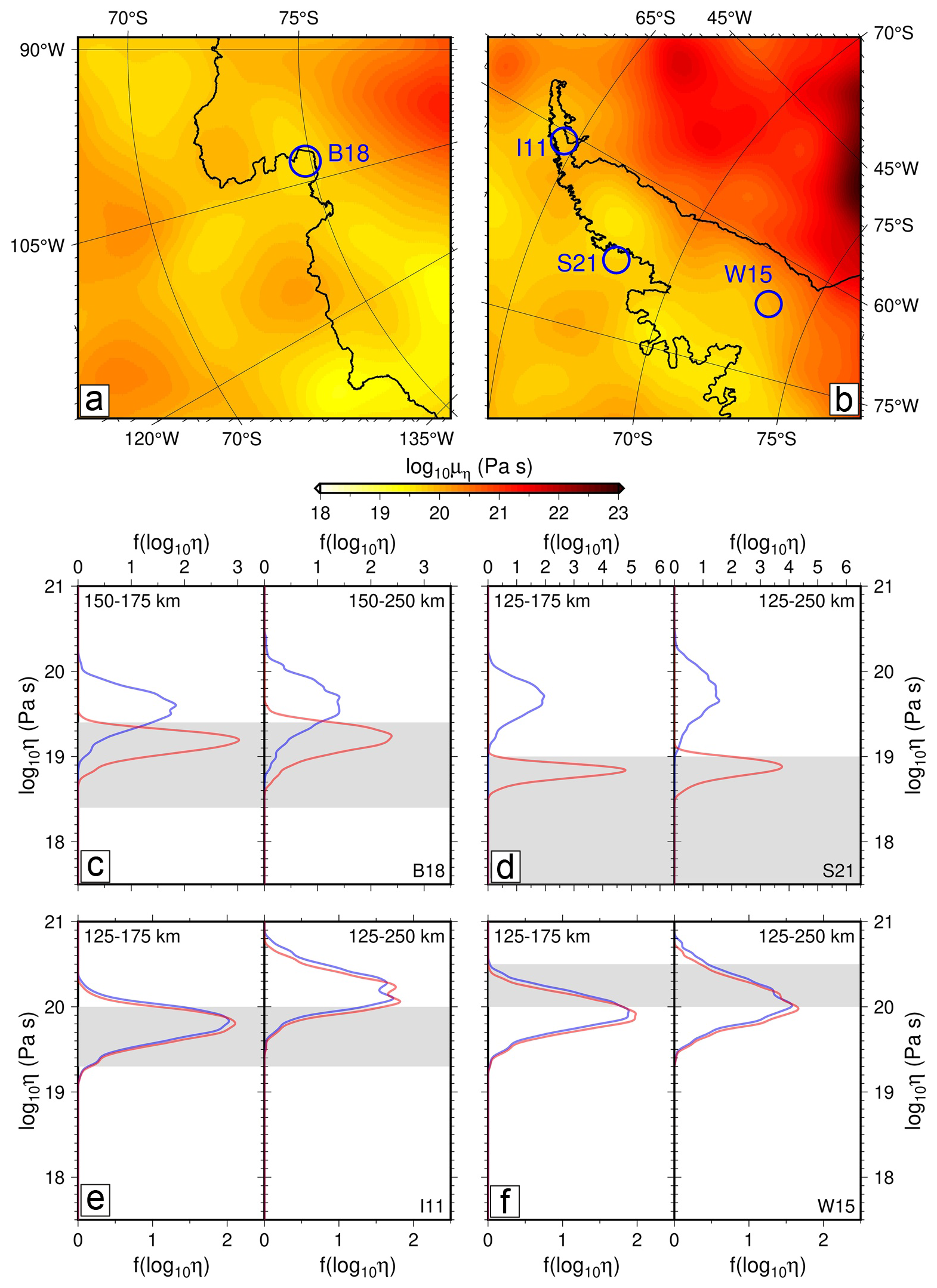
Figure 13Comparison of upper mantle viscosity estimates based on GPS observations and on shear-wave velocity structure converted to viscosity using calibrated experimental parameterisations of frequency-dependent viscoelasticity (Yamauchi and Takei, 2016; Lloyd et al., 2020; Hazzard et al., 2023). Panels (a) and (b) show the mean viscosity structure at 150 km depth beneath the Amundsen Sea Embayment and the Antarctic Peninsula, respectively, with lateral sampling regions overlain in blue. (c–f) Probability density distribution of inferred diffusion creep steady-state (blue) and time-dependent (red) viscosity compared to geodetic estimates (gray) from the sample regions indicated in the upper panels (B18, S21, I11, and W15 are shown in panels c, d, e, and f, respectively). From Hazzard et al. (2023, Fig. 13). B18: GPS observations 2002–2014, ice retreat from 1900 to 2014, viscosity estimate log 10η=18.4…19.4 (Barletta et al., 2018); S21: GPS observations 1999–2020, ice retreat from 1999 to 2020, viscosity estimate log 10η=17.5…19.0 (Samrat et al., 2021); I11: GPS observations 2003–2009, overall retreat from LGM to present, viscosity estimate log 10η=19.3…20.0 (Ivins et al., 2011); W15: GPS observations 2009–2013, ice retreat from LGM to present, viscosity estimate log 10η=20.0…20.5 (Wolstencroft et al., 2015).
The spatial resolution of regional vertical land motion can be aided by expanding the number of GNSS installations, especially in regions with low mantle viscosity and/or considerably heterogeneous viscosity structure (Lucas et al., 2025). The horizontal displacement pattern should be taken into consideration in such regions. This type of improved spatial characterization will also help us to determine if GIA-induced land motion is a driver for processes that stabilise or destabilise the grounding line. This instability mechanism, termed MISI (cf. Sect. 1), was investigated, among others, by Schoof (2012), Gomez et al. (2024), Morlighem et al. (2024) and van Calcar et al. (2025). On the one hand, the stability (or steady-state equilibrium) depends on the retreat or advance of the grounding line under the condition of net mass loss or gain. Stability can be reached only in locations “where bedrock slopes downwards sufficiently steeply” (Schoof, 2012). A delay in GIA-induced land motion due to high underlying mantle viscosity means that the grounding line retreats into deeper water thus leading to further mass loss and grounding line retreat. On the other hand, under a low climate forcing, bedrock uplift that changes the regional negative bedrock slope, together with a relative sea-level fall in the vicinity of the lost ice mass, may reduce the ice loss at the grounding zone and lead to a stabilization effect. That said, Gomez et al. (2024) argue that, under strong climate forcing and an underlying mantle with short relaxation times, ice-sheet retreat exceeds any counteracting uplift effect and sea-level feedback (Fig. 14). Thus, GNSS-inferred displacement data with improved spatial coverage would provide input conditions for the coupled ice-sheet/GRD models that are currently being used to generate projections for important collaborative efforts, such as ISMIP7 and the IPCC reports.
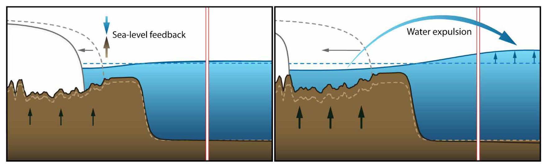
Figure 14Sketch illustrating sea-level feedback and water expulsion mechanisms. Dashed lines denote original position and extent, respectively, of ice sheet, bedrock and ocean surface. Under low climate forcing, a sea-level feedback mechanism dominates where uplifting bedrock and lowering sea surface beneath marine sectors, underlain by low viscosity, reduce ice loss across the grounding line, leading to reduced far-field sea-level rise (left panel). Exposed ocean areas in Antarctica continue to rebound, expelling water and increasing far-field sea level more relative to the scenario with a rigid bed (right panel). Under low climate forcing, the sea-level feedback dominates and GIA reduces (marine) ice-sheet contribution to GMSL. Under strong climate forcing, the ice-sheet retreat is too fast, and bedrock uplift does not have a substantial feedback regardless of whether a rigid (non-deforming) or 3D viscoelastically deforming Earth model is adopted. Hence, sea-level feedback is weaker and water expulsion is the dominant effect amplifying ice-sheet contribution to GMSL. From Gomez et al. (2024).
2.10 Broad implications: Space Weather Research and Atmospheric Parameters
Space weather refers to phenomena that occur in the upper atmosphere, mainly in the thermosphere and ionosphere. Space weather and geophysical research have many interconnections including shared research questions and synergies in logistics and instrument deployment. For example, the processing of GNSS measurements for geodetic research requires understanding of variations in the ionosphere that affect signal propagation. As another example, GNSS receivers are often deployed by both the space weather and geophysical research communities, with both communities needing GNSS receiver coverage in the same Antarctic regions. Today, space weather is considered a natural hazard that increasingly threatens both human life and technology, particularly as we move toward further reliance on infrastructure that is vulnerable to extremes in space weather phenomena.
There are several reasons why Antarctic measurements (Fig. 15) of the geomagnetic field as well as the ionosphere and thermosphere conditions are crucial to our understanding of and ability to forecast space weather. First, the space environment over the northern and southern polar regions is not symmetric, and the interplay between asymmetries, which vary on a range of temporal and spatial scales, has profound global impacts on a number of space weather phenomena. Thus, it is not possible to comprehensively understand or forecast such phenomena without simultaneous observational constraints in both the Antarctic and the Arctic. Second, certain processes at high geomagnetic latitudes can only be observed, or are best observed, in Antarctica since high magnetic latitudes in the Arctic are mostly in the ocean, where observations are challenging or impossible. Third, there are processes in the polar atmosphere/ionosphere that can only be studied in Antarctica as they occur more frequently and/or have different properties in that region when compared to the Arctic. For all of these reasons, the importance of Antarctic space weather measurements is emphasised by Kennicutt et al. (2014), and inspires the goals and science questions of the SCAR Antarctic Geospace and ATmosphere reseArch (AGATA) Scientific Research Programme (https://scar.org/science/research-programmes/agata, last access: 11 May 2025) as well as those of other international and national space weather research organizations. An additional driver is that GNSS sites in the Antarctic Peninsula and parts of West Antarctica lie at magnetically conjugate latitudes to areas of North America where ionospheric observatories exist, thus allowing direct comparison of datasets during solar storms and other ionospheric phenomena (e.g., Meng et al., 2025).
There are many interconnections between geoscientific and terrestrial weather/atmospheric and space weather research, which have potential for intensified exploitation. Ground-based GNSS receivers are not only used by the geodetic research community (cf. Sect. 2.2) but also provide a key diagnostic used for space weather research: total electron content along the line of sight between the ground-based receiver to a given GNSS satellite. This diagnostic is useful for both fundamental space weather research (e.g., Yue et al., 2016; Zou et al., 2023) and as an input to space weather nowcast and forecast models. It is particularly important in the high-latitude Southern Hemisphere as this region is sparsely sampled; yet, it plays an important role in determining global geospace dynamics. It is now standard practice for measurements from various repositories to be aggregated and processed to general global 2D maps of the ionosphere electron content (e.g., Rideout and Coster, 2006; Alfonsi et al., 2022). The need for expanded networks returning near real-time data is likely to increase in the next decade to feed space weather nowcasts/forecasts (e.g., several activities related to the implementation of the PROSWIFT legislation in the USA, SWIMMR initiative in the UK, PECASUS ICAO Consortium). Other examples of mutual-interest instrumentation include magnetometers, electrometers and magnetotelluric stations, weather packages (measurements of wind, temperature, etc.), and aerosol units (such as in the AERONET network).
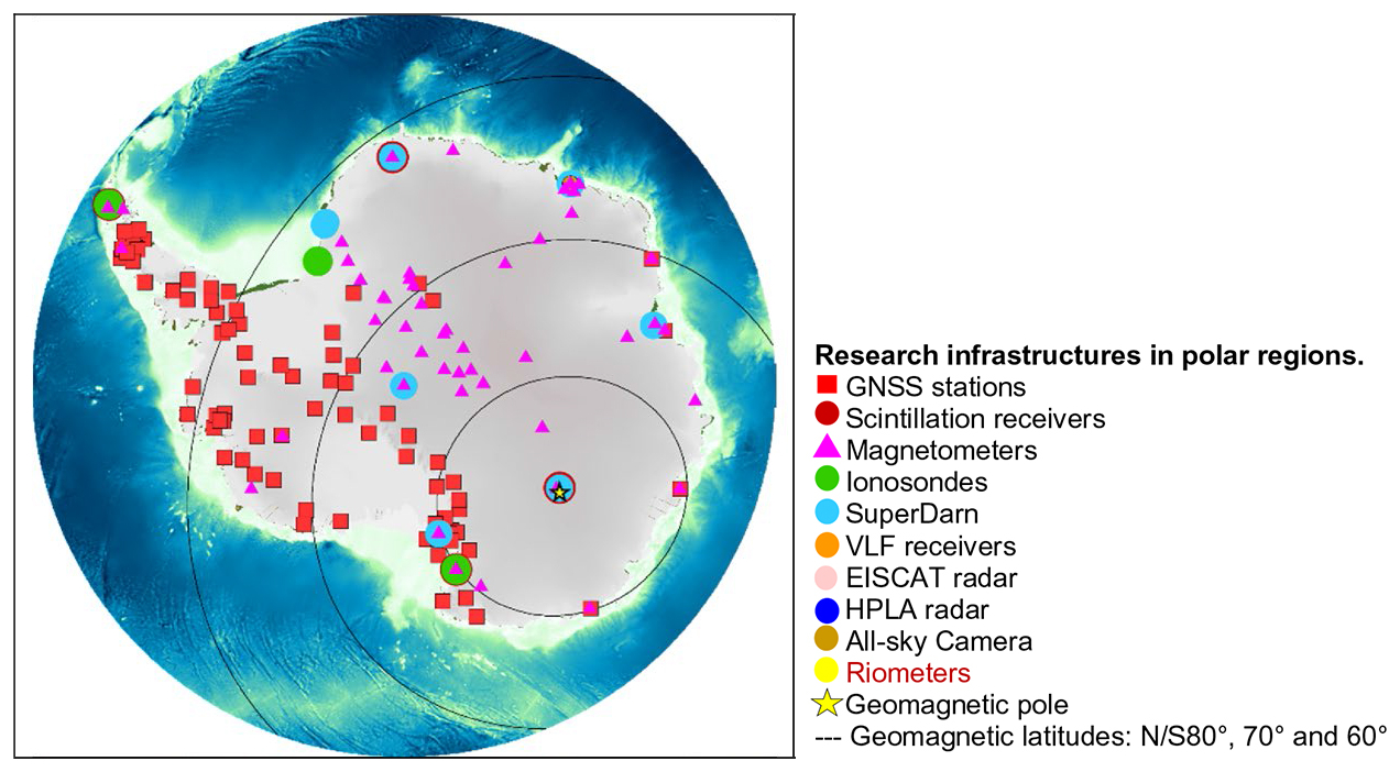
Figure 15Shared deployments of scientific instrumentation infrastructure across Antarctica (selected established stations are shown to indicate the coverage of measurements). GNSS receivers are described as GNSS stations and scintillation receivers; different type of radars for neutral and ionized atmosphere observation are described as ionosondes, SuperDARN, EISCAT radars, HPLA radars; HF receivers for lower ionosphere observation are indicated as riometers; all-sky camera identifies the instruments for optical observation of the middle-upper atmosphere; finally the magnetometer locations are shown in the map. Notably, Antarctic GNSS stations and magnetometers are rarely co-located, limiting our progress in addressing topic research questions. The geomagnetic pole and the geomagnetic parallels from 60 to 80° S are drawn to identify the regions of interest to study the Sun-Earth interaction over Antarctica. Figure modified from Alfonsi et al. (2022, Fig. 1).
Beyond the progress achieved so far in understanding the complex interactions between the AIS, solid Earth, atmosphere, and ocean, as reviewed in Sect. 2, a multitude of important science questions remain open. We present a list of these questions in Appendix A and will concisely discuss the most important aspects in Sect. 3.1. Section 3.2 presents special characteristics of key Antarctic areas that make them particularly suitable for attacking specific science questions, while subsequent subsections elaborate on enhanced observational capabilities (Sect. 3.3) and advancing international cooperation (Sect. 3.4).
3.1 Science priorities
Arguably, a primary science priority is the need to decisively improve our ability to produce accurate projections of Antarctica's contribution to GMSL rise. This includes better projections of how much and how fast the AIS will lose mass in response to a warming climate. To achieve this, more precise and reliable information on the ice sheet's dynamic response to Earth system feedbacks are required. In this respect, understanding GIA is a key to characterising the coupled GRD response. Respective models need to be upgraded to integrate more complexity and capture spatio-temporal variations, for the ultimate purpose of monitoring and predicting grounding line migration and corresponding ice-sheet instabilities (Whitehouse et al., 2019). Continued ground-based observations across the entire continent are indispensable for providing constraints on model parameters and the resultant model predictions. Moreover, Antarctica is, in fact, a natural laboratory to study a range of processes and feedbacks within the Earth system which cannot be captured elsewhere.
3.1.1 Ice-mass balance and global change (Questions 1 to 6)
Estimating current and future sea-level change on global and regional scales constitutes one of the most urgent global science questions today. Antarctica's contributions to sea-level change cannot be captured without continuously monitoring the AIS mass balance (Horwath et al., 2022; Ludwigsen et al., 2024). For this, a consistent, accurate, and reliable geodetic reference frame has to be provided and maintained over the long term. The International Terrestrial Reference Frame (ITRF) (Altamimi et al., 2023) forms a backbone to measure climate-related changes that affect the shape of the Earth, including elevation changes in topographic, sea, and ice surfaces. In this respect, geodesy provides critical infrastructure to climate science (https://ggim.un.org/UNGGCE/documents/Policy_Brief_Geodesy_is_critical_to_climate_science.pdf, last access: 15 July 2025). Additional permanent GNSS installations can complement existing IGS GNSS sites in Antarctica to provide data for future ITRF realizations. Furthermore, it is of the utmost importance to extend the number of tide gauge installations since they provide independent in-situ observations of relative sea level. GNSS-IR at coastal installations provide an alternative to gain further in-situ sea-level measurements (cf. Sect. 2.2.7; Peng et al., 2021).
Our understanding of the interplay between AIS mass balance and GIA is critical, particularly where the mass and gravity effect has to be taken into account. As stated in Sects. 1 and 2.9, the GIA mass correction still causes the largest uncertainty in mass balance estimates based on satellite gravimetry. This problem has to be urgently addressed, requiring GIA model capabilities to incorporate full coupling between ice sheet and gravity, rotation and deformation feedbacks. As these types of coupled models emerge, benchmarking and undertaking model intercomparison projects (MIP) in collaboration with other currently ongoing initiatives from the ice sheet, ocean dynamics, and climate science communities are essential. Forward modelling of GIA is underpinned by knowledge of Earth structure and ice loading histories. The ice history is the largest uncertainty in many regions of Antarctica (van der Wal et al., 2023). Thus, there is a need for improvement through, for example, incorporation of glacial-geological constraints or ice-dynamic modelling. This is particularly acute in areas of Antarctica with weaker mantle, where it is important to determine ice-sheet changes over the last few centuries, and where the loading effects of the better-constrained Last Glacial Maximum ice-sheet extent and thickness are less relevant (van der Wal et al., 2023).
Antarctica is also a critical environment for observing and assessing other impacts resulting from global climate change. For example, monitoring changes in atmospheric structure, including water vapor, albedo, and aerosols, using various instruments and methodologies is of great importance. Long-term analyses of these and other parameters from distributed locations across Antarctica would make substantial contributions to climate and general circulation models and to future predictions relevant to atmospheric and cryospheric research. For example, long-term precipitable water vapor trends can be obtained via GNSS techniques using networks such as POLENET (Negusini et al., 2021), and regular radiosonde launches can be used to monitor several parameters (e.g., pressure, temperature, relative humidity) relevant to global climate change and ice-atmosphere interactions (see Alfonsi et al., 2022, for a detailed discussion of this topic). There are also connections with space weather via two-way coupling/forcing with the ionosphere and thermosphere as well as changes in atmospheric chemistry from cosmic rays. In short, there are many physical linkages between the ionosphere, atmosphere, cryosphere, ocean, and the solid Earth that are crucial to our understanding of the dynamics in each of these regions. As such, there is great need for interdisciplinary collaborations and coordinated observational campaigns, data assimilation, and modelling efforts to improve our understanding of these connections and to enhance the accuracy and reliability of general circulation/climate models.
3.1.2 The benefit of expanding the temporal and spatial coverage of geodetic observations (Questions 7 to 11)
To effectively address the questions of different time and spatial scales, both in the ice-load history and the response of the solid Earth, we have to consider and enhance the temporal and spatial resolution of bedrock displacement data provided by GNSS networks, together with the insights gained from seismological networks. Historically, the linear Maxwell model, which is the simplest model of Earth's viscoelastic rheology, has been used to predict GIA in Antarctica. This is partly due to the lack of ground-based and in-situ observational evidence to justify more complex rheological models. Evidence from outside of Antarctica, particularly from post-seismic and laboratory studies, strongly suggests that the asthenosphere and upper mantle are unlikely to behave according to a Maxwell model; instead, transient deformation phases likely exist, such as those described by an extended Burgers material (EBM) model (Lau and Holtzman, 2019; Ivins et al., 2022) or power-law rheology (van der Wal et al., 2015; Blank et al., 2021). Ivins et al. (2023b) showed that significant trade-offs exist between the amplitude of transient relaxation and its timescale when only linear trends are considered.
Previous work that investigated post-seismic deformation using satellite gravimetry (Broerse et al., 2014) and GNSS records (Klein et al., 2016) has shown that continuous time series, spanning multiple years with weekly to monthly displacement rates, can be used to successfully isolate the rheological parameters that control transient relaxation time and amplitude. In their study of post-seismic deformation, Nield et al. (2023) suggested that additional rheological complexity somewhat improves model agreement with GNSS coordinate time series. Future large earthquakes present important opportunities to probe the mantle rheology beneath Antarctica, more so than past earthquakes in the Antarctic Peninsula, since the GNSS network is now more extensive and provides higher quality observations. Our ability to remove contaminating signals, such as SMB, has also greatly improved. The Scotia Arc, in particular, experiences regular Mw>7 earthquakes that may deform the Antarctic Peninsula. modelling these deformations is still in its infancy and, as with GIA, will require models that consider lateral solid-Earth variations as well as modern ice-loading changes (Nield et al., 2023).
Extended GNSS observations of Earth deformation, combined with increasingly sophisticated seismological and GIA models, are required to improve constraints on rheology. This was exemplified for regions with low mantle viscosity, like the Amundsen Sea Embayment, to test competing rheological models and to couple them with ice-sheet evolution (Barletta et al., 2018; Gomez et al., 2024). The massive ice loss in the drainage basins of the Amundsen Sea Embayment provides a natural experiment to probe the viscoelastic properties of the Earth's interior, especially in terms of its heterogeneity (Lucas et al., 2025). Likewise, events such as the rapid onset of deformation in the Antarctic Peninsula following the 2002 Larson-B ice-shelf breakup provide a globally unique natural experiment on shallow mantle rheology in the context of well-observed changes in surface loading. Thus, displacement time series spanning a decade or more are essential for characterising the transient and steady-state viscosity. Maintaining and extending the current GNSS network, not only in regions with low viscosity but also throughout the continent, is essential to enable new breakthrough discoveries regarding mantle rheology. This is of great importance for regions where GIA model uncertainty is a dominant uncertainty, as especially in East Antarctica where there is not yet agreement as to the sign of mass change (The IMBIE Team, 2018; Otosaka et al., 2023). Further improvements in the rheological models will, in turn, require seismic (e.g., Ivins et al., 2023b), magnetotelluric (e.g., Lijun and Hasterok, 2016), and geological observations.
Similarly, expanding the number of GNSS installations in regions with low mantle viscosity (like the Amundsen Sea Embayment) is extremely important to be able to improve the spatial resolution of local vertical land motion as well as to incorporate horizontal displacement patterns (Lucas et al., 2025). Processes that can either stabilise or destabilise ice-sheet retreat (e.g., Schoof, 2012; Gomez et al., 2024) could be tested using a denser network of GNSS measurement sites.
Holocene changes of the AIS (retreat and re-advance) remain poorly defined by geological, geomorphological, and ice dynamics studies. However, these are important for present-day deformation rates, with the exact time period of relevance depending on regional upper mantle viscosity and the magnitude of load change. In much of West Antarctica, load changes in the recent few hundred to a few thousand years are important (Bradley et al., 2015; Wolstencroft et al., 2015; Nield et al., 2012), whereas in East Antarctica, with a longer relaxation time, load changes over several millenia are likely most relevant (King et al., 2022; Johnson et al., 2022). This might be even more crucial in view of contemporary ice-mass gain in regions of East Antarctica, which may lead to subsidence, further hindering a correct separation of past and present-day effects.
3.1.3 Earth structure, rheology, and geodynamics (Questions 12 to 17)
Determining the lithospheric structure and mantle rheology beneath Antarctica is not only essential to our understanding of Earth's response to changing loads on different temporal and spatial scales, but it also provides powerful insights into the tectonic processes shaping the continent. To address these topics, seismic studies in Antarctica are taking full advantage of evolving data processing capabilities (e.g., full waveform and adjoint tomography), which are fostering a range of scientific discoveries. Further, these seismic constraints can be converted to temperature and composition estimates (e.g., Faul and Jackson, 2005; Ivins et al., 2023b), which in turn, can be used to estimate lithospheric thickness and mantle rheology (e.g., Austermann et al., 2015; Ivins et al., 2023b). Both conversions rely on mineral physics constraints (e.g., Hirth and Kohlstedt, 2003; Wu et al., 2012). While inherent uncertainties and trade-offs between parameters, inferred from these constraints, must be considered, geophysical proxies are still the most expedient avenue toward generating spatially extensive estimates of these important lithosphere-asthenosphere characteristics. Ensemble approaches (e.g., Mordret, 2018) can be employed to evaluate the range of plausible thermal and viscosity structures, thereby allowing for quantitative assessments of mantle flow variations and ice-sheet behavior. Plate motion and tectonic deformation can also be inferred from GNSS-inferred 3D coordinate time series, which provide information on temporal deformation patterns. That said, open questions remain with respect to the separability of horizontal displacement rates due to GIA and horizontal velocities due to plate motion (King et al., 2016; Turner et al., 2020; Vardić et al., 2022). Improved estimates of Antarctica's mantle rheology will help to improve GRD modelling. These objectives also highlight that expanded Antarctic seismic and geodetic observations serve two complementary purposes. First, they improve regional constraints on Antarctic lithospheric structure, mantle rheology, and solid-Earth response to changing ice loads. Second, because of Antarctica's unique high-latitude geometry and sparse existing coverage, additional stations also improve global sampling of the deeper mantle and core. Thus, future network expansion should be designed to address both Antarctic Earth-system science and broader questions of planetary interior structure.
Further, ground-based geodetic-geophysical measurements also contribute to gain a better understanding of the ice-bedrock interface across the transition from the grounded ice sheet to the ocean. This region records interactions on grounding-line migration, changes in ice loading, solid-Earth deformation, and relative sea-level change, all of which can influence the stability and evolution of marine-based ice sheets (e.g., MISI, see Sect. 2.9). Characterizing the IBIZ (see Sect. 2.8.2), its offshore extension, and the underlying lithospheric and mantle structure is, therefore, important for linking the solid-Earth structure beneath Antarctica to that beneath the surrounding Southern Ocean. Tide gauges provide a particularly valuable ground-based observations by recording relative sea-level change (see Sect. 2.3) and linking solid-Earth deformation with ocean observations. More generally, resolving the onshore–offshore transition requires integrating ground-based geophysical measurements with marine, airborne and satellite-based observations (see Matsuoka et al., 2026, for a comprehensive review).
3.1.4 Structure of the deep mantle and Earth's core (Questions 18 to 21)
Antarctic seismic investigations are critical in terms of addressing questions about deeper mantle structure and the Earth's core. At greater depths, the mantle transition zone provides an important bridge between Antarctic lithospheric and upper-mantle processes, and the dynamics of the deeper mantle, as discussed in Sect. 2.4.1 and 2.4.2. Variations in the depths of the 410 and 660 km discontinuities and in transition-zone thickness can constrain thermal anomalies and potentially distinguish shallow upper-mantle processes from deeper upwelling. Existing observations suggest localized transition-zone anomalies beneath parts of West Antarctica and the Transantarctic Mountains. However, present seismic coverage remains insufficient to determine their lateral extent or whether they reflect processes extending from the lower mantle. Expanded broadband seismic coverage would, therefore, help establish whether Antarctic volcanism, rifting, and other upper-mantle anomalies are primarily shallow phenomena or are linked to deeper mantle dynamics.
Further topics do directly influence the continent itself, others are broader-scale questions that are relevant to the large-scale inner workings of our planet. For example, recent studies have highlighted anomalously slow features just above the core-mantle boundary (CMB) beneath Antarctica, which could be the remnants of subducted slabs (e.g., Hansen et al., 2020, 2023; Agboola et al., 2024). These rock materials may be associated with a ubiquitous layer in the deep mantle, with variable thermal and chemical characteristics. If present, this layer could have notable effects on core heat flux, the formation and dynamics of mantle plumes, and/or coupling mechanisms between the mantle and the core (e.g., Nakagawa and Tackley, 2010; Li and Zhong, 2017; Mound et al., 2019), but further CMB seismic imaging is needed to evaluate this possibility. Seismic data collected in Antarctica have also made major contributions to our understanding of the structure, rotation, and rheology of Earth's core. For instance, seismic studies have shown differential rotation between the inner core and the mantle, with the inner core accelerating and decelerating in recent years, and this temporal variability may be associated with viscous deformation, meaning the inner core is not as solid as originally thought (e.g., Tkalčić et al., 2013; Vidale et al., 2025), but more data are needed to confirm these observations. Seismic stations in Antarctica provide a unique vantage point to record waves that sample these deep portions of our planet.
3.1.5 Cryospheric processes (Questions 22 to 28)
Monitoring the AIS and predicting its future evolution requires improved understanding of individual processes, the inter-linkage between them, and their feedbacks across boundary interfaces, including the subglacial bed, atmosphere, and ocean. Geophysical networks provide important observables to advance cryospheric research.
Antarctic seismology also encompasses the study of the force systems and source processes that excite seismic waves. From such investigations, we have learned much about the different geodynamic processes (e.g., tectonic, volcanic, cryospheric) that shape the continent. Cryospheric seismicity can be extraordinarily prolific, including that associated with grounding zone, basal, hydrologic, ocean wave, crevassing, calving, and iceberg process (Fig. 11). However, most events are small, and seismic source studies in Antarctica are thus impeded by a lack of station coverage of sufficient density (see Sect. 2.4.3). Additional broadband, as well as targeted nodal and/or DAS seismic systems, are required to further identify, locate, and interpret cryoseismicity. DAS systems offer transformative broadband capabilities for massive multichannel and uniquely spatially dense seismic wavefield sensing that include the capability to readily incorporate both near-surface and ice borehole fiber optic cables. Such 3D sensor deployment geometries, incorporating sensing below the high-gradient and attenuating firn layer, can realise lower-noise sensing and provide exceptional resolution of source processes as well as static and time-varying cryospheric seismic structure (e.g., Booth et al., 2020; Hudson et al., 2021; Brisbourne et al., 2021; Yang et al., 2024; Brisbourne et al., 2024; Fichtner et al., 2025; Agnew et al., 2025; Hudson et al., 2025; Fichtner et al., 2026). Machine learning-based and other methods providing reliable automatic filtering and event detection can be readily applied to such large datasets (e.g., Ross et al., 2018; Zhu and Beroza, 2018; Woollam et al., 2019; Mousavi et al., 2020; Ho et al., 2024; Zitt et al., 2025), and fuzzy logic or machine learning classification algorithms can be employed to differentiate between glacial versus non-glacial sources (e.g., Gajek et al., 2017; Saltiel et al., 2024; Kharita et al., 2024; Latto et al., 2024). Ideally such technical advancements might offer methods of detection of ice fracturing and calving details in regions with marine cliffs that exceed 80 m in height, thus playing an observational role in assessing the viability of the MICI process at present day or in the near future (e.g., Sun and Gudmundsson, 2026).
Cryospheric processes involving snowfall, compaction, surface snowforms, and ablation create a dynamic boundary zone that strongly affects seismic wave propagation (e.g., Chaput et al., 2018; Yang et al., 2024). In addition, surface mass balance plays an important role in understanding and correctly capturing present-day ice-mass change. GNSS-IR at stations installed on the ice has the potential to provide valuable ground truth data on snow surface height and upper firn or glacial structure due to its depth-penetrating signal (Nievinski and Larson, 2014a, b).
The large-scale ambient seismic wavefield in Antarctica at periods longer than a few seconds is generated by ocean waves acting near the coasts (Anthony et al., 2015) and is thus strongly influenced by the presence or absence of seasonal sea ice (e.g., Pratt et al., 2017). Investigations of the IBIZ (Sect. 2.8.2), for example, should be preferentially carried out in late summer when the highest amplitudes of this wavefield can potentially yield details on sub-ice sediments and the crust, and can likely be obtained even from relatively short-duration passive seismic deployments. Techniques that rely on earthquake signals require longer deployments (typically one to two years, minimum), and these can also potentially provide information on secular or seasonal changes in the IBIZ.
3.2 Key Areas for Future Geodetic-Geophysical Observations
In the following subsections we highlight specific regions of Antarctica that are of greatest scientific interest either because continuous, long-time series in these regions are of utmost importance and/or observational gaps need to be closed in order to answer the critical questions discussed in Sect. 3.1. We recommend that future field locations be targeted in multiple ways: (1) conventional gap-guided targeting where current datasets are especially sparse, (2) model-guided targeting to identify key locations where new data would have high impact (McCormack et al., 2022), and (3) anchor-dataset guided targeting to improve the performance of statistical and machine learning approaches. Contemporary targeting strategies can provide a highly impactful addition to the gap-guided approach within the priority regions below.
3.2.1 West Antarctica and Amundsen Sea Embayment
Glaciers in West Antarctica are undergoing rapid ice loss in response to changing atmospheric and oceanic conditions (Poinelli et al., 2025). In particular, rates of ice loss at Pine Island Glacier and Thwaites Glacier in the Amundsen Sea Embayment have increased fivefold over the past few decades (Shepherd et al., 2019). Glaciers in this region are already large contributors to sea-level rise (Rignot et al., 2019) but total collapse of the WAIS would raise sea level by over 3 m (Bamber et al., 2009).
Due to the significant ice loss occurring in this region and the inferred low mantle viscosity (see Sect. 2.2.3), this is a primary region to probe Earth's rheology. The Amundsen Sea Embayment has the highest GNSS-derived vertical displacement rates of anywhere in Antarctica and even on the entire planet (Fig. 8), and the fast response of the solid Earth to changes in present-day ice loss provides a natural experiment to constrain the rheologic structure, particularly transient behaviour, from long and continuous GNSS time series. Furthermore, seismic imaging has constrained small-scale (less than 100 km) spatial variability in upper mantle viscosity in this region (Lucas et al., 2025). Including localised lateral viscosity variations in GIA models can substantially affect model-predicted crustal deformation and relative sea-level changes (Lucas et al., 2025) and, therefore, can impact solid Earth–ice sheet–sea-level feedbacks that may act to stabilise retreat of the WAIS in the future.
3.2.2 Antarctic Peninsula
The upper mantle viscosity beneath the Antarctic Peninsula has been inferred to be several orders of magnitude lower than the global average (cf. Sect. 2.2.3, Figs. 4 and 8). Faster solid-Earth response times in the Amundsen Sea region indicate that present-day displacement is dominated by changes in the ice sheet occurring over decades to centuries instead of millennia.
The ice history in this region is complex, and over the past 2000 years there have been periods of both ice loading and unloading as the climate has fluctuated (Nield et al., 2012; Wolstencroft et al., 2015). Ongoing GNSS measurements, in conjunction with GIA models, will enable us to unravel the relative contribution of past ice changes to present-day displacement.
On a decadal time scale, widespread retreat and collapse of ice shelves since the 1970s has led to an acceleration and thinning of tributary glaciers, resulting in increased ice-mass loss (Cook and Vaughan, 2010). The solid-Earth response to this ice loss has already been observed in GNSS time series (Nield et al., 2014; Samrat et al., 2020; Nield et al., 2025). In the future, continuous GNSS measurements offer the opportunity to observe the Earth's response to ice-mass changes as the system regains equilibrium and rates of ice loss diminish. Furthermore, the GNSS network in the Antarctic Peninsula is important to maintain in order to capture the Earth's response to possible future ice shelf collapses and subsequent rapid ice loss. This will enable us to place tighter constraints on the Earth's rheology, including identification of potential transient behaviours, but this is only possible with long, continuous time series.
3.2.3 Ellsworth and Coats Land and the Filchner-Ronne Ice Shelf
Our knowledge of AIS deglaciation around the Filchner-Ronne Ice Shelf remains a critical source of uncertainty in GIA models. There are large misfits between GIA model predictions and GNSS observed uplift rates in this region, particularly on the western side of the Ronne Ice Shelf (Wolstencroft et al., 2015), with many GIA models significantly over-predicting uplift rates (Whitehouse et al., 2019). This suggests existing models of deglaciation are incorrect.
A possible explanation for the misfit is that the glaciation history is not sufficiently captured in the modelling. In this region, the ice sheet may have retreated behind the present-day grounding line during the Holocene and subsequently readvanced (Bradley et al., 2015; Kingslake et al., 2018). This later loading associated with readvancement would damp the uplift predicted by GIA models and reduce the misfit to GNSS observed displacement, particularly at sites showing subsidence (Bradley et al., 2015). Here, GNSS networks provide important constraints on model output, particularly because the role of GIA in retreat and readvancement is currently being debated (Lowry et al., 2024).
Coats Land remains the region of Antarctica where GIA models show the biggest differences in uplift rates. Leading GIA models estimate uplift of approximately the same magnitude, but the opposite sign (Whitehouse et al., 2019). Continued measurements of bedrock displacement are imperative to improving GIA models in this area.
3.2.4 East Antarctica
East Antarctica exhibits regions of different characteristics. The Transantarctic Mountains mark the boundary between cratonic East Antarctica and rifted West Antarctica. The deep structure of this boundary, documented by seismic studies, shows a profound change in crustal thickness and inferred mantle viscosity. Understanding how these structure and rheological gradients modulate the Earth's response to changing ice-sheet mass needs to be advanced through targeted GNSS and seismic measurements. Recent geodetic evidence has suggested the Transantarctic Mountains may be uplifting much slower than previously suggested by geodetic estimates, in disagreement with some GIA model predictions (Koulali et al., 2025).
Northern Victoria Land is another key area of investigation. While MISI has been highlighted within marine basins in West Antarctica (e.g., Joughin et al., 2014; Rignot et al., 2014), improved ice thickness measurements in East Antarctica (e.g., Greenbaum et al., 2015) reveal the presence of several deep basins that may have been prone to the MISI in the past and may be again in the future (e.g., Stokes et al., 2022). For example, the Wilkes Subglacial Basin (at approximately 145°E, west of Victoria Land, cf. Fig. 1) may have significantly contributed to past sea-level change (e.g., Raymo and Mitrovica, 2012; Blackburn et al., 2020) and could contribute up to 3–4 m of sea-level rise in the future (e.g., Mengel and Levermann, 2014; Stokes et al., 2022). As discussed recently by National Academies Press (2024), parts of East Antarctica are rapidly losing mass and may have even greater potential for sea-level contributions than West Antarctica. As such, Northern Victoria Land was highlighted as a priority target for focus on current and future sea-level rise.
The vast coastal zone of East Antarctica has been explored to different extents in terms of geophysical observables. GNSS recordings on bedrock are sparse, especially in eastern Dronning Maud Land (approximately 15 to 35° E), Enderby and Kemp Land (approximately 40 to 60° E), and from 75 to 155° E longitude (cf. Fig. 3). However, large marine basins within East Antarctica could substantially contribute to future sea-level rise, particularly on multi-century timescales and under high-end climate warming scenarios. For example, new evidence published by Hansen and Emry (2025) shows that the mantle beneath submarine portions of the Wilkes and Aurora Subglacial Basins may be underlain by low-viscosity mantle. Modern ice-mass balance estimates for East Antarctica also disagree, not just in terms of magnitude but even in terms of sign (The IMBIE Team, 2018). Some of the regions, especially eastern Dronning Maud Land, Enderby, and Kemp Land, are thought to be associated with positive ice-mass balance in recent years. Glaciers in these areas are still grounded when they reach the ocean. Other parts of East Antarctica host glaciers that are marine-based, such as the Denman and Totten Glaciers.
Jones et al. (2022) proposed significant and rapid thinning, with grounding line retreat beyond its current position, along the entire east AIS margin during the early to mid-Holocene. Subsequent ice-sheet readvance has also been found in parts of East Antarctica, such as near Rauer Islands (e.g., Berg et al., 2010) and further east at the Bunger Hills (e.g., Berg et al., 2020). King et al. (2022) advocated that an ice readvancement is the reason for GIA-related subsidence (−0.5 to −2 mm a−1) west of Denman Glacier, as inferred by GNSS data. Densified and continuous GNSS time series recordings are critical to help unravel Holocene ice-sheet retreat and re-advance. Collocated geophysical measurements, like seismology and magnetotellurics (Ramirez et al., 2022; Manassero et al., 2026), are needed to narrow down mantle rheology parameters. Thus, expanding observational networks in this region will provide foundational knowledge of ice-Earth interactions.
3.2.5 The South Pole Region and Deep Antarctic Interior
Across the vast expanse of Antarctica, the region surrounding the South Pole holds particular scientific importance. The South Pole lies within East Antarctica, near the southern end of the Transantarctic Mountains. Understanding the subsurface properties in this region is not only essential for tectonic reconstructions of the East Antarctic craton but is also essential for assessment of its regional influence on ice dynamics and global climate. The East Antarctic Ice Sheet, which overlies this area, exhibits significant topographic variations, indicative of complex mantle dynamics and geothermal anomalies, all of which impact past and ongoing ice-sheet evolution. Despite the scientific significance of the South Pole and its surroundings, this region remains poorly studied given sparse seismic coverage, with limited focused studies close to the Amundsen Scott South Pole station confirming the presence of sub-ice sediments and regions of sub-ice melt (e.g., Peters et al., 2008; Hills et al., 2022). Only one permanent (Global Seismographic Network) seismic station (QSPA/SPA) is located at the South Pole (blue triangle in Fig. 3) with its nearest broadband neighbor over 250 km away (Anthony et al., 2021; Ringler et al., 2022).
3.3 Enhanced Observational Capabilities
Technological advances are essential to answer the key scientific questions outlined in Sect. 3.1 and 3.2. Both long-running (several years or longer than a decade) and short-term (months to years) geophysical observations are foundational to improving our understanding of the Antarctic continent. Improvements in instrumentation over the past decade(s) have included data loggers and sensors designed for the harsh climatic conditions and integration of satellite communications in sensors. That said, there is room for improvement, particularly in power consumption and communications. While most aspects of geophysical and geodetic deployment design are constantly evolving to improve both data quality and efficiency, in the following subsections we highlight several avenues that will provide the greatest benefits to the polar Earth science community.
3.3.1 Improved autonomous power solutions
Lowering the power consumption of geophysical instrumentation and GNSS equipment remains a high priority since power systems at remote locations remain a significant component of the logistical burden; their failure creates observational gaps. In the US, IRIS and UNAVCO, the predecessor organizations of the EarthScope Consortium, drew on decades of polar operations to develop and refine the first generation of autonomous seismic and GNSS stations. EarthScope has now received continued NSF support for polar instrumentation and operational activities. Looking forward, collaboration among facilities such as EarthScope, university researchers, and industry partners specialising in wind power, cold-proof batteries, power management, and new telecommunication capabilities could substantially improve the reliability and capability of the next generation of autonomous polar geophysical systems.
Particularly for power systems, solar power is a practical solution during the Antarctic summer, but year-round operation through the polar night requires substantial energy storage and, in many cases, complementary wind generation. Conventional systems typically rely on large banks of deep-cycle batteries, which add considerable mass and volume and can be difficult and hazardous to transport to remote sites (cf. Figs. 7, 9). Therefore, system design involves a trade-off between lower-cost but logistically burdensome lead-acid batteries and lighter, higher-cost lithium-based systems. Although rechargeable lithium batteries require careful thermal management and protection from low-temperature charging, recent deployments have demonstrated increasingly promising performance. Wind turbines can provide valuable power in polar winter, but remain vulnerable to icing, extreme winds, mechanical failure, and excess energy production when batteries are fully charged. Future systems should, therefore, integrate cold-tolerant batteries, battery-management systems, active thermal control, hybrid solar-wind charging, diversion loads, and low-power telemetry into lightweight, modular power architectures designed for reliable multi-year operation.
3.3.2 Reliable low-power data telemetry
A principal challenge for remote deployments is station telemetry to provide instrument state-of-health and to transfer data, thus reducing the frequency of site visits. Although successfully implemented with Iridium for GNSS data, telemetry remains an issue for the relatively large data-volumes recorded by seismic deployments. As a result, most seismic instruments in Antarctica (deployed away from permanent stations) require periodic service visits to recover the full dataset. Although taking advantage of newly-deployed, fast-developing, low-orbit satellite constellations seems to be an attractive solution, greater power will be required and these systems are often developed by private companies, which could pose additional reliability and cost risks compared with state-owned systems. Emerging enablers for both seismic and multivariate data analysis include high-volume data transfer optimised by data analysis on-location, followed by satellite transfer of a reduced volume of partly processed data (known as edge computing; Ji et al., 2024). For some field deployments, and in combination with semi-automated data processing, this will enable new observation approaches as well as streamlining data transfer for established techniques.
3.3.3 Joint approaches for key properties and observations
The concept of considering joint constraints on key properties offers the potential for step-change advances in inferring key properties of the Antarctic subsurface. An example of a promising combined technique is the joint consideration of seismic and magnetotelluric data, which provides better constraints on mantle viscosity (Ramirez et al., 2022; Manassero et al., 2026), an important input in GIA studies (cf. Sect. 2.9). Further, the use of high-precision radar sounding may provide a ground-breaking way of enabling GNSS time-series data to yield information about bedrock displacement in ice-covered locations (Schroeder et al., 2024).
3.3.4 Ease and Duration of Deployment
Traditionally, geophysical and geodetic instruments in remote areas have been deployed in two principal ways: (1) land-traverses by snowmobiles/tracked vehicles or (2) airborne support by fixed-wing aircraft or helicopters. Instruments are often deployed near remote camps, or their installation is coordinated within larger international collaborative programs that use both land-traverses and airborne support. Ski-equipped fixed-wing aircraft allow the community to reach some of the farthest, and otherwise most difficult, regions of Antarctica, and this has served as the backbone logistical foundation for field programs such as POLENET. However, long-distance flights limit ground time and deployment capacity. Long-distance land traverses, on the other hand, require extensive logistical preparations. Moreover, although well designed to survive the Antarctic winter and other environmental challenges, current polar instrumentation is still bulky and requires large logistical resources for its transportation and deployment.
Other options are being explored to reduce logistical burdens, including diverse means of transportation and new techniques that reduce logistic dependencies. For example, in some regions, wheeled vehicles (e.g., Arctic Trucks; https://arctictrucks.com/, last access: 16 September 2025) provide long-distance traverse capabilities with light-weight logistics support. Lighter, smaller, and more powerful observational capabilities (e.g., combined instrument types), coupled with wheeled vehicles, lead to better deployment potential for large-scale observational networks at costs traditionally associated with small field campaigns. This is an important issue because the ground time needed for installation and maintenance is a decisive factor in logistical planning. This also relates to the topic of data retrieval. If full datasets can be telemetered, logistically expensive site visits can be dramatically reduced. That said, snow accumulation at long-term, autonomous site locations must also be considered, and new systems will need to be designed so that they are locatable and eventually retrievable under such conditions.
3.4 Advancing Antarctic Science Through International Cooperation: A Forward-Looking Strategy
Many of the science goals detailed in this review require access to overlapping regions of Antarctica and have a shared interest in the deployment of common instruments. Unfortunately, due to limited coordination between past projects, instruments are often not collocated. For example, magnetometers tend to be deployed on the East Antarctic Plateau, whereas dense networks of GNSS receivers are often deployed in West Antarctica or in coastal regions (Fig. 3). In the future, our ability to fully address the science goals will depend on ambitious data collection campaigns, including, for example, rolling deployments of seismic and other geophysical instruments and acquisition of continuous, long-term GNSS time series. A key requirement is data acquisition at large spatial scales to answer questions across the Antarctic continent. However, large-scale and long-term instrument deployments pose special obstacles because logistical support for deep fieldwork at remote sites is challenging and expensive. As noted in a series of Antarctic science vision reports over the past decades (National Academies Press, 2012, 2015; SCAR, 2023), a crucial means to overcome logistical obstacles is by pooling resources from many nations. Sharing field logistics and resources would benefit multiple research communities and would enable stronger arguments to be made to access particularly remote, difficult to reach portions of Antarctica. Therefore, community discussions point toward multi-national collaboration as a necessary pathway for achieving the next generation of Antarctic geophysical and geodetic observations.
3.4.1 Strengthening Geophysical and Geodetic Community Planning
National and multi-national long-term science plans are a proven means to achieve consensus on priorities and establish a plan for successive science goals, used, for example, by the ice coring and astrophysics polar communities (National Academies Press, 2023; National Science Foundation, 2026a, b). Establishing such plans for Antarctic geophysical deployments can send clear messages to national Antarctic research programs on future science priorities and logistical needs that require multi-national support. Multiple strategies to achieve this are suggested below.
Engage internationally through SCAR and COMNAP
SCAR provides a central forum for grass roots development of international science plans. Forming “Action Groups” under the SCAR science groups can be used to engage scientists with parallel interests, achieve consensus on science priorities, and form strategies for acquiring the relevant data sets to achieve science goals. Biennial SCAR conferences provide regular opportunities to gather the international science community and advance planning. SCAR groups can engage with the Council of Managers of National Antarctic Programs (COMNAP) (https://www.comnap.aq/, last access: 16 September 2025) to present their goals and strategies and discuss feasible approaches for coordinated field campaigns that can be implemented by multiple nations.
Information Platform and Open Data
Collaboration in both science and field campaigns could be advanced by implementing a platform to disseminate information on research projects and planned field programs. Excellent models of such systems are the ISAAFFIK Arctic Gateway (Denmark) (https://isaaffik.org/, last access: 16 September 2025), a user driven web platform supporting Arctic research and collaboration, and the Southern Ocean Observing System (SOOS) (https://soos.aq/, last access: 16 September 2025), currently based in Australia, which aims to facilitate and enhance Southern Ocean observations. Polar instrument systems pose unique engineering challenges due to extreme environmental conditions and months without sunlight as well as logistical challenges, such as limited cargo capacity and ground time at remote sites. Information exchange on successful engineering solutions on a range of instrument system scales can greatly improve efficiency for field deployments and continuous data collection. An information platform with content on technology, together with community discussions, perhaps modeled after the U.S. Polar Technology workshops, could support information exchange and foster innovative development. In the U.S., EarthScope (https://www.earthscope.org/, last access: 16 September 2025) represents a successful model for focused efforts, driving technological development, facilitating measurement campaigns, and archiving data to service the geophysical and geodetic communities.
The value of Antarctic geophysical observations can be greatly augmented by adopting open data protocols. One crucial step would be to establish an international network for scientific data transmission from Antarctica. Communication with remote instruments documents operational health and allows satellite transfer of data, both of which significantly reduce requirements for site visits and the overall logistical footprint. Data should be transferred to open access repositories, all interlinked internationally and adhering to the FAIR principle (findable, accessible, interoperable and reusable data) (Wilkinson et al., 2016).
Maintaining a healthy community
Deep-field polar fieldwork requires unique skills in planning for and operating in remote, extreme environments. Introducing students and early career researchers to fieldwork as members of field teams serves to open doors for them to become successful independent polar researchers. It is important for national Antarctic research programs to enhance opportunities for field participation for early-career scientists.
Enhancing individual skills in using geophysical data effectively, as well as facilitating the creation of innovative new approaches to data use, is essential to amplify the value of geophysical datasets acquired with great effort and expense. One proven model is implementation of multidisciplinary, international training schools (Sherman et al., 2025). Community workshops on new data analysis methods and applications are also keystone activities to promote advanced data use.
3.4.2 Establishing multi-national planning and funding mechanisms
It is universally agreed that international collaboration is crucial to meet Antarctic science objectives that cannot be achieved by a single nation; yet, substantial barriers to the implementation of international programs remain. Several models for multinational research programs in Antarctica have been used successfully. One model, used for many programs during IPY-4, relies on research groups seeking funding for a collaborative science plan from their own national agencies and logistical support programs. A similar model also requires successful proposals from research teams in multiple nations, but logistical support is pooled, and the contribution from each national program is established by a “memorandum of understanding”. These approaches have “multiple jeopardy” in that each national program must approve both science funding and logistical support for the research plan to succeed. At present, there is no established mechanism for review/award for a single proposal from a multi-nation research team. Developing multi-national funding mechanisms could provide the means to achieve instrument deployments at large spatial scales and over longer time frames. This challenge has been recognised for more than two decades. Workshops on the future of Antarctic airborne and seismic instrument deployment (Denver 2002, Finn et al., 2003; Boulder 2003, Ritzwoller et al., 2003) already emphasised that continent-scale Antarctic geophysical observations would require flexible international partnerships, shared logistical support, and coordination across national Antarctic programs.
Although past collaborative mechanisms have achieved greater science breadth and spatial scope for measurement campaigns, the challenge of support for long-term plans remains, either for sequential deployments planned in different regions or long-duration time series acquisitions. A further challenge is that national funding and logistical programs often prioritise innovative, hypothesis-driven field campaigns, whereas many of the most critical Antarctic geophysical and geodetic observations depend on continuity rather than novelty. Long-term time series gain scientific value through persistence, enabling detection of rare events, separation of transient and steady-state signals, and monitoring of evolving ice–solid Earth–ocean interactions. Sustaining these observations therefore requires support mechanisms that recognise maintenance, data continuity, and network resilience as essential scientific activities.
An international consortium model has the potential to support long-term science plans and alternative options for logistical support, while providing flexibility in the level of science funding and logistical commitments from national programs. For example, a polar geophysics consortium, aligned with SCAR planning efforts and coordinated with existing community facilities and data systems, could critically aggregate community priorities, sustain technical knowledge, develop shared observing strategies, and create pathways for universities, federal agencies, logistical partners, and more importantly, private foundations, to support long-term Antarctic geophysical observations. In a mode similar to the former International Ocean Discovery Program (IODP) (https://www.iodp.org/, last access: 8 November 2026) or the current IceCube (https://icecube.wisc.edu/, last access: 8 November 2026) program, nations with Antarctic research programs could contribute funding to a consortium to support deep-field logistic platforms capable of remote geophysical deployments. Nations could select their level of funding and logistical contributions, which could be modified through time. Proposals focused on polar geophysical data analysis, submitted by individual investigators, could include a budget to support the data acquisition that their science relies on, to be contributed to support a consortium. A consortium could also provide a pathway for non-governmental foundations or other organizations to contribute to science support. A multi-national science advisory structure would maintain an updated science plan and establish priorities for field campaigns. Maintaining a flexible funding pool would allow innovative approaches to field support, such as contracting air or land traverse support from non-governmental organizations. Such a pool could also support a data transfer collaboration. The science arm of the consortium could take on tasks such as creating an information platform and promoting innovative data analysis, as highlighted above.
3.4.3 Planning for the next International Polar Year
The 5th International Polar Year (IPY-5) (https://ipy5.net/, last access: 15 December 2025), planned for 2032–2033, offers unique opportunities for multidisciplinary and multinational Antarctic research. The preceding IPY-4 (2007–2008) created a framework to initiate new collaborations and to elevate Antarctic geophysical networks to a new, unprecedented level. For example, the POLENET project (spanning both the Antarctic and Arctic) was one of the largest projects initiated during IPY-4 (Wilson et al., 2011), and it has yielded a wealth of new discoveries (see Sect. 2) as well as a crop of younger generation polar geophysicists, who are fueling current efforts. This review paper provides the framework for community efforts to advance Antarctic Earth science through geophysical measurements for IPY-5.
The AIS, comprising 70 % of global freshwater, contributes substantially to GMSL rise, recently estimated at 0.4 mm a−1. The high uncertainty in future projections stems significantly from a lack of well-founded knowledge regarding the properties of the solid Earth and its response to ice-mass variations, which can stabilise or destabilise the AIS. Specifically, GIA model uncertainty accounts for about one-third of the total AIS mass change amplitude estimated from satellite gravimetry. Addressing this problem requires improved measurements of bedrock displacement and of solid-Earth properties beneath Antarctica, especially regarding viscoelasticity.
GNSS data sets have revolutionised our understanding of geodynamics in Antarctica, demonstrating that solid-Earth processes are relevant to climate studies and that past assumptions of an Antarctic land mass, that is limited to only slow isostatic response (≥1000 years), are incorrect. Starting in the 1990s with a focus on plate tectonics, geodetic GNSS observations now suggest a coherent Antarctic plate motion without large internal tectonic deformation. Since then, our knowledge of the response of the solid Earth has considerably expanded, supported by long GNSS time series and seismic networks. In addition, seismological recordings provide crucial, independent constraints on the Earth's internal structure, particularly mantle viscosity, which is a key parameter for GIA models, and sub-ice geology, which provides critical boundary conditions for ice dynamics.
Since 2000, more than 400 GNSS and seismic stations have been deployed across Antarctica. We note that deployments are unevenly distributed, concentrated along the Transantarctic Mountains, the Antarctic Peninsula, and in West Antarctica, reflecting the availability of exposed bedrock for GNSS monumentation. This uneven coverage leaves substantial gaps, especially in East Antarctica, which continues to limit our ability to correctly identify ice-load history and solid-Earth structure effects in GIA. Further, in order to discriminate deformation processes at shorter time scales (centuries to decades) and to investigate possible GIA-related processes that may stabilise or further destabilise the ice sheet, GNSS recordings at higher spatial resolution are needed in select regions. Notably, in order to constrain key properties of the Earth's internal structure, joint deployments of additional GNSS and seismic stations, along with other geophysical observations, provides a promising way for the future. For instance, the joint consideration of seismic and magnetotelluric data may provide improved bounds for plausible a priori mantle viscosity models. Finally, we note that as future Antarctic deployments focus on key science questions, they will also generate new unexpected discoveries and knowledge.
Future efforts must decisively move beyond basic mapping to focus on coupled systems modelling. This requirement will already be taken into account in upcoming projects such as Antarctica InSync (https://www.antarctica-insync.org/, last access: 15 December 2025) and IPY-5. The two most critical needs are:
-
Consistently testing and modelling a realistic mantle rheology (including lateral inhomogeneities and transient relaxation) alongside AIS mass changes across all timescales.
-
Developing coupled ice-sheet/ocean/GRD models that fully integrate the complex nature of the sub-ice geology as well as the solid Earth–ice sheet–ocean interaction to yield accurate projections of GMSL change.
To achieve climate-relevant certainty in Antarctic mass loss and sea-level contribution, sustained and strategically placed geophysical observations (GNSS, seismic, and additional sensors) are essential to constrain Earth structure and improve GIA modelling. The solid-Earth community must prioritise filling observational gaps to inform comprehensive, predictive Earth system models.
Below, we present the list of science questions that are referred to in Sect. 3.1.
-
What ongoing GNSS observations in Antarctica best contribute to realizing a global geodetic reference frame that would allow for high-resolution measurements of climate, ice-mass and sea-level changes, and to resolve GIA-related deformation in polar regions?
-
How can a considerably extended number of in-situ sea-level recordings at the Antarctic coast, taken by tide gauges and/or by GNSS reflectometry, be used to improve observations of regional sea-level change?
-
How is the AIS mass balance currently changing, both in terms of regional surface mass changes and ice dynamical responses?
-
In which way(s) should our understanding of GIA corrections with respect to ice-mass balance and geoid change be revised?
-
What processes do coupled ice-sheet/GRD models need to include, and how can we assess their accuracy?
-
How can we improve our understanding of climate, general atmospheric circulation, and space weather in Antarctica?
-
How can observed bedrock displacements be used to investigate Earth's short-time anelastic and viscoelastic responses to contemporary mass load changes?
-
To what extent can currently measured bedrock displacements help to discriminate long-term (millennial) and short-term (centuries to decades) solid-Earth response to AIS mass change, and be used to unravel Holocene ice-sheet retreat and re-advance?
-
What is the sensitivity of current and future GIA model predictions of bedrock displacement to present-day observational constraints?
-
How has ongoing deformation from mass loading that occurred before the instrumental record affected ice-sheet dynamics during the past, and how might this inform us about projections of the future evolution of the AIS, bedrock, and sea level?
-
What additional data are needed to independently constrain the ice sheet's history (e.g., from glacial geology and/or ice core records)?
-
What is the composition, rheology, thermal regime and tectonic history of the crust and the lithosphere?
-
How do we consistently characterise (upper) mantle rheology, including both lateral viscosity variations and transient relaxation? How can we distinguish between their relative importance and contributions?
-
What are the connections between onshore and offshore structures and their geodynamic implications?
-
What are the connections between earthquake-triggered (postseismic) and GIA-related deformation, and how can this be used to probe mantle rheology?
-
What is the absolute motion of the Antarctic plate, and is there active intraplate tectonic deformation within the continent?
-
Are there geodynamically active regions of Antarctica that have yet to be identified and, if so, what are their corresponding origins?
-
How does the structure of the mantle transition zone vary beneath Antarctica, and does it indicate regions affected by deeper mantle Earth processes?
-
What is the lowermost mantle structure beneath the Southern Hemisphere and how does this inform us about mantle convection processes and high temperature, high pressure mineral physics?
-
Are there anomalous structures along the core-mantle boundary, and if so, what are their origins?
-
What are the internal structures and boundary processes for the outer and inner cores?
-
What are the subglacial properties and processes relevant for past and future ice-sheet dynamics?
-
What role do geological controls, erosion, and sedimentation play in ice-sheet dynamics?
-
How do glaciological, geological, and geophysical records inform us about ice-sheet and landscape evolution, including submarine and subglacial morphologies?
-
How can seismic instrumentation help reveal the extent, formation, and healing of fractures that create rifts in ice shelves?
-
How can the spatial and temporal distribution of seismic events further inform us about glacial processes and their feedback with oceanic and atmospheric conditions?
-
What are the relationships between basal stick-slip events and sub-ice geologic conditions?
-
What is the full content of the seismic wavefield?
No data sets were used in this article.
MS and WS designed the concept and structure of the manuscript. MS coordinated the writing and editing of the manuscript. All co-authors contributed to the writing of the original draft as well as to reviewing and editing of the final paper.
The contact author has declared that none of the authors has any competing interests.
Publisher's note: Copernicus Publications remains neutral with regard to jurisdictional claims made in the text, published maps, institutional affiliations, or any other geographical representation in this paper. The authors bear the ultimate responsibility for providing appropriate place names. Views expressed in the text are those of the authors and do not necessarily reflect the views of the publisher.
The following colleagues are acknowledged for contributing comments and notes for additional references: Monia Negusini (IRA/INAF, Italy), Wojciech J. Miloch (University of Oslo, Norway), Mustafa F. Karabulut (Fırat University, Türkiye), Hasan H. Yavaşoğlu (Istanbul Technical University, Türkiye), Oktar Özgün and Burcu Özsoy (Polar Research Institute, Türkiye), Nicolas Bergeot (Royal Observatory of Belgium), Vera Schlindwein (Alfred Wegener Institute Helmholtz Centre for Polar and Marine Research, Germany).
This study is a contribution to the SCAR Scientific Research Programmes “Instabilities and Thresholds in Antarctica” (INSTANT) and “Antarctic Geospace and ATmosphere reseArch” (AGATA). This is a contribution to the Australian Antarctic Science Decadal Strategy.
We would like to acknowledge the reviewers Caroline van Calcar, Wouter van der Wal and Douglas Wiens. Their comments and suggestions helped us a great deal to improve the quality of the paper.
Matt King and Anya Reading were supported by the ARC Australian Centre for Excellence in Antarctic Science (Project ID SR200100008) and the Australian Government’s Australian Antarctic Program (Project 4547). Matt King and Anya Reading are also supported by ARC Laureate Fellowships (project IDs FL250100022 and FL250100087, respectively). Weisen Shen and Richard Aster were supported in coordinating associated international 2022 Colorado State University, Fort Collins, Colorado, and 2024 Herndon, Virginia, INSTANT I and II workshops (U.S. NSF award 2235061).
This paper was edited by Susanne Buiter and reviewed by Douglas Wiens, Caroline van Calcar, and Wouter van der Wal.
Adhikari, S., Ivins, E. R., Larour, E., Seroussi, H., Morlighem, M., and Nowicki, S.: Future Antarctic bed topography and its implications for ice sheet dynamics, Solid Earth, 5, 569–584, https://doi.org/10.5194/se-5-569-2014, 2014. a
Adhikari, S., Caron, L., Ivins, E. R., Han, H. K., Houriez, L., and Larour, E.: Enabling ice sheet models to capture centennial-scale solid Earth feedback with relative ease and sufficient accuracy, The Cryosphere, 20, 5041–5060, https://doi.org/10.5194/tc-20-5041-2026, 2026. a
Agboola, K. J., Hansen, S. E., Garnero, E. J., Rost, S., Li, M., and Shim, S.: Ultra‐Low Velocity Zones Beneath the Southern Hemisphere Imaged With Double‐Array Stacking of PcP Waveforms, J. Geophys. Res.-Sol. Ea., 129, https://doi.org/10.1029/2023jb028170, 2024. a, b
Agnew, R. S., Pearce, E., Karplus, M., Ranganathan, M., Hoffman, A. O., Hunt, M., Pretorius, A., Shanly, S. E., Beres, M., Pradhan, K. K., Seldon, Y., Booth, A. D., Clark, R. A., and Jan Young, T.: Active and Passive Seismic Surveys over the Grounding Zone of Eastwind Glacier, Antarctica, Seismol. Res. Lett., 97, 591–605, https://doi.org/10.1785/0220250024, 2025. a
Aitken, A. R. A., Young, D., Ferraccioli, F., Betts, P. G., Greenbaum, J. S., Richter, T. G., Roberts, J. L., Blankenship, D. D., and Siegert, M. J.: The subglacial geology of Wilkes Land, East Antarctica, Geophys. Res. Lett., 41, 2390–2400, 2014. a
Aitken, A. R. A., Li, L., Kulessa, B., Schroeder, D., Jordan, T. A., Whittaker, J. M., Anandakrishnan, S., Dawson, E. J., Wiens, D. A., Eisen, O., and Siegert, M. J.: Antarctic Sedimentary Basins and Their Influence on Ice‐Sheet Dynamics, Rev. Geophys., 61, https://doi.org/10.1029/2021rg000767, 2023. a, b
Alfonsi, L., Bergeot, N., Cilliers, P. J., De Franceschi, G., Baddeley, L., Correia, E., Di Mauro, D., Enell, C.-F., Engebretson, M., Ghoddousi-Fard, R., Häggström, I., Ham, Y.-B., Heygster, G., Jee, G., Kero, A., Kosch, M., Kwon, H.-J., Lee, C., Lotz, S., Macotela, L., Marcucci, M. F., Miloch, W. J., Morton, Y. J., Naoi, T., Negusini, M., Partamies, N., Petkov, B. H., Pottiaux, E., Prikryl, P., Shreedevi, P. R., Slapak, R., Spogli, L., Stephenson, J., Triana-Gómez, A. M., Troshichev, O. A., Van Malderen, R., Weygand, J. M., and Zou, S.: Review of Environmental Monitoring by Means of Radio Waves in the Polar Regions: From Atmosphere to Geospace, Surv. Geophys., 43, 1609–1698, https://doi.org/10.1007/s10712-022-09734-z, 2022. a, b, c
Altamimi, Z., Rebischung, P., Collilieux, X., Métivier, L., and Chanard, K.: ITRF2020: an augmented reference frame refining the modeling of nonlinear station motions, J. Geodesy, 97, https://doi.org/10.1007/s00190-023-01738-w, 2023. a, b
Amalvict, M., Willis, P., Wöppelmann, G., Ivins, E. R., Bouin, M.-N., Testut, L., and Hinderer, J.: Isostatic stability of the East Antarctic station Dumont d’Urville from long-term geodetic observations and geophysical models, Polar Res., 28, 193–202, https://doi.org/10.1111/j.1751-8369.2008.00091.x, 2009. a
An, M., Wiens, D. A., Zhao, Y., Feng, M., Nyblade, A. A., Kanao, M., Li, Y., Maggi, A., and Lévêque, J.: S‐velocity model and inferred Moho topography beneath the Antarctic Plate from Rayleigh waves, J. Geophys. Res.-Sol. Ea., 120, 359–383, https://doi.org/10.1002/2014jb011332, 2015. a, b
Anandakrishnan, S., Voigt, D. E., Burkett, P. G., Long, B., and Henry, R.: Deployment of a broadband seismic network in West Antarctica, Geophys. Res. Lett., 27, 2053–2056, https://doi.org/10.1029/1999gl011189, 2000. a
Andrews, J. and Deuss, A.: Detailed nature of the 660 km region of the mantle from global receiver function data, J. Geophys. Res.-Sol. Ea., 113, https://doi.org/10.1029/2007jb005111, 2008. a
Anthony, R., Aster, R., Wiens, D., Anandakrishan, S., Huerta, A. D., Winberry, J. P., Wilson, T., and Rowe, C.: The Seismic Noise Environment of Antarctica, Seismol. Res. Lett., 86, 89–100, https://doi.org/10.1785/0220140109, 2015. a, b, c, d, e
Anthony, R. E., Aster, R. C., and McGrath, D.: Links between atmosphere, ocean, and cryosphere from two decades of microseism observations on the Antarctic Peninsula, J. Geophys. Res.-Earth Surf., 122, 153–166, https://doi.org/10.1002/2016jf004098, 2017. a, b, c
Anthony, R. E., Ringler, A. T., DuVernois, M., Anderson, K. R., and Wilson, D. C.: Six Decades of Seismology at South Pole, Antarctica: Current Limitations and Future Opportunities to Facilitate New Geophysical Observations, Seismol. Res. Lett., 92, 2718–2735, https://doi.org/10.1785/0220200448, 2021. a, b
Ardhuin, F., Gualtieri, L., and Stutzmann, E.: How ocean waves rock the Earth: Two mechanisms explain microseisms with periods 3 to 300 s, Geophys. Res. Lett., 42, 765–772, https://doi.org/10.1002/2014GL062782, 2015. a
Argus, D. F., Blewitt, G., Peltier, W. R., and Kreemer, C.: Rise of the Ellsworth mountains and parts of the East Antarctic coast observed with GPS, Geophys. Res. Lett., 38, https://doi.org/10.1029/2011gl048025, 2011. a
Argus, D. F., Peltier, W. R., Drummond, R., and Moore, A. W.: The Antarctica component of postglacial rebound model ICE-6G_C (VM5a) based on GPS positioning, exposure age dating of ice thicknesses, and relative sea level histories, Geophys. J. Int., 198, 537–563, https://doi.org/10.1093/gji/ggu140, 2014. a
Arora, D., Pant, N. C., Stål, T., Naik, A., Pandey, M., and Gupta, R.: Geothermal heat flow in the Princess Elizabeth Land sector, East Antarctica, Earth Sci. Rev., 277, https://doi.org/10.1016/j.earscirev.2026.105475, 2026. a
Aschwanden, A., Bueler, E., Khroulev, C., and Blatter, H.: An enthalpy formulation for glaciers and ice sheets, J. Glaciol., 58, 441–457, https://doi.org/10.3189/2012jog11j088, 2012. a
Aster, R. and Simons, M.: Future Geophysical Facilities Required to Address Grand Challenges in the Earth Sciences, Community Report to the National Science Foundation, Incorporated Research Institutions for Seismology, Workshop, Leesburg (VA), 4–6 May 2015, https://web-archive-2022.iris.edu/hq/files/publications/other_workshops/docs/futures_report.pdf (last access: 8 November 2026), 2015. a
Aster, R., Zandomeneghi, D., Mah, S., McNamara, S., Henderson, D. B., Knox, H., and Jones, K.: Moment tensor inversion of very long period seismic signals from Strombolian eruptions of Erebus Volcano, J. Volcanol. Geoth. Res., 177, 635–647, https://doi.org/10.1016/j.jvolgeores.2008.08.013, 2008. a
Aster, R. C. and Winberry, J. P.: Glacial seismology, Rep. Prog. Phys., 80, 126801, https://doi.org/10.1088/1361-6633/aa8473, 2017. a, b, c
Aster, R. C., McNamara, D. E., and Bromirski, P. D.: Global trends in extremal microseism intensity, Geophys. Res. Lett., 37, L14303, https://doi.org/10.1029/2010gl043472, 2010. a
Aster, R. C., Lipovsky, B. P., Cole, H. M., Bromirski, P. D., Gerstoft, P., Nyblade, A., Wiens, D. A., and Stephen, R.: Swell-Triggered Seismicity at the Near-Front Damage Zone of the Ross Ice Shelf, Seismol. Res. Lett., 92, 2768–2792, https://doi.org/10.1785/0220200478, 2021. a, b
Aster, R. C., Ringler, A. T., Anthony, R. E., and Lee, T. A.: Increasing ocean wave energy observed in Earth’s seismic wavefield since the late 20th century, Nat. Commun., 14, https://doi.org/10.1038/s41467-023-42673-w, 2023. a, b
Austermann, J., Pollard, D., Mitrovica, J. X., Moucha, R., Forte, A. M., DeConto, R. M., Rowley, D. B., and Raymo, M. E.: The impact of dynamic topography change on Antarctic ice sheet stability during the mid-Pliocene warm period, Geology, 43, 927–930, https://doi.org/10.1130/g36988.1, 2015. a
Bagge, M., Klemann, V., Steinberger, B., Latinović, M., and Thomas, M.: Glacial‐Isostatic Adjustment Models Using Geodynamically Constrained 3D Earth Structures, Geochem. Geophys. Geosyst., 22, https://doi.org/10.1029/2021gc009853, 2021. a
Bamber, J. L., Riva, R. E. M., Vermeersen, B. L. A., and LeBrocq, A. M.: Reassessment of the Potential Sea-Level Rise from a Collapse of the West Antarctic Ice Sheet, Science, 324, 901–903, https://doi.org/10.1126/science.1169335, 2009. a
Baranov, A. and Morelli, A.: The Moho depth map of the Antarctica region, Tectonophysics, 609, 299–313, https://doi.org/10.1016/j.tecto.2012.12.023, 2013. a
Baranov, A., Tenzer, R., and Morelli, A.: Updated Antarctic crustal model, Gondwana Res., 89, 1–18, https://doi.org/10.1016/j.gr.2020.08.010, 2021. a
Barcheck, G., Brodsky, E. E., Fulton, P. M., King, M. A., Siegfried, M. R., and Tulaczyk, S.: Migratory earthquake precursors are dominant on an ice stream fault, Sci. Adv., 7, eabd0105, https://doi.org/10.1126/sciadv.abd0105, 2021. a, b
Barletta, V. R., Bevis, M., Smith, B. E., Wilson, T., Brown, A., Bordoni, A., Willis, M., Khan, S. A., Rovira-Navarro, M., Dalziel, I., Smalley, R., Kendrick, E., Konfal, S., Caccamise, D. J., Aster, R. C., Nyblade, A., and Wiens, D. A.: Observed rapid bedrock uplift in Amundsen Sea Embayment promotes ice-sheet stability, Science, 360, 1335–1339, https://doi.org/10.1126/science.aao1447, 2018. a, b, c, d, e, f
Bayer, B., Geissler, W. H., Eckstaller, A., and Jokat, W.: Seismic imaging of the crust beneath Dronning Maud Land, East Antarctica, Geophys. J. Int., 178, 860–876, https://doi.org/10.1111/j.1365-246x.2009.04196.x, 2009. a, b
Becker, J. N., Aster, R. C., Rapoport, Y., Lee, T. A., Simons, F. J., Ringler, A. T., and Anthony, R. E.: Global Seasonal Microseism Intensity and Hemispheric Asymmetry, Seismol. Res. Lett., 97, 3414–3437, https://doi.org/10.1785/0220260057, 2026. a
Begeman, C. B., Tulaczyk, S. M., and Fisher, A. T.: Spatially variable geothermal heat flux in West Antarctica: Evidence and implications, Geophys. Res. Lett., 44, 9823–9832, https://doi.org/10.1002/2017gl075579, 2017. a
Bellas-Manley, A., Kang, K., Becker, T. W., and Nerem, R. S.: 3D Variations in Viscosity Reconcile the Strength of the Lower Mantle Inferred from Glacial Isostatic Adjustment and Mantle Convection, Geophys. Res. Lett., 53, https://doi.org/10.1029/2025GL120160, 2026. a
Berdahl, M., Leguy, G., Lipscomb, W. H., Urban, N. M., and Hoffman, M. J.: Exploring ice sheet model sensitivity to ocean thermal forcing and basal sliding using the Community Ice Sheet Model (CISM), The Cryosphere, 17, 1513–1543, https://doi.org/10.5194/tc-17-1513-2023, 2023. a
Berg, S., Wagner, B., White, D. A., and Melles, M.: No significant ice-sheet expansion beyond present ice margins during the past 4500 yr at Rauer Group, East Antarctica, Quaternary Res., 74, 23–25, https://doi.org/10.1016/j.yqres.2010.04.004, 2010. a
Berg, S., Melles, M., Gore, D. B., Verkulich, S., and Pushina, Z. V.: Postglacial evolution of marine and lacustrine water bodies in Bunger Hills, Antarct. Sci., 32, 107–129, https://doi.org/10.1017/s0954102019000476, 2020. a
Berrocoso, M., Prates, G., Fernández-Ros, A., and García, A.: Normal vector analysis from GNSS–GPS data applied to Deception volcano surface deformation, Geophys. J. Int., 190, 1562–1570, https://doi.org/10.1111/j.1365-246x.2012.05584.x, 2012. a
Bevis, M., Kendrick, E., Smalley, R., Dalziel, I., Caccamise, D., Sasgen, I., Helsen, M., Taylor, F. W., Zhou, H., Brown, A., Raleigh, D., Willis, M., Wilson, T., and Konfal, S.: Geodetic measurements of vertical crustal velocity in West Antarctica and the implications for ice mass balance, Geochem. Geophys. Geosyst., 10, https://doi.org/10.1029/2009gc002642, 2009. a
Bina, C. R. and Helffrich, G.: Phase transition Clapeyron slopes and transition zone seismic discontinuity topography, J. Geophys. Res.-Sol. Ea., 99, 15853–15860, https://doi.org/10.1029/94jb00462, 1994. a
Bingham, R. G., Bodart, J. A., Cavitte, M. G. P., Chung, A., Sanderson, R. J., Sutter, J. C. R., Eisen, O., Karlsson, N. B., MacGregor, J. A., Ross, N., Young, D. A., Ashmore, D. W., Born, A., Chu, W., Cui, X., Drews, R., Franke, S., Goel, V., Goodge, J. W., Henry, A. C. J., Hermant, A., Hills, B. H., Holschuh, N., Koutnik, M. R., Leysinger Vieli, G. J.-M. C., MacKie, E. J., Mantelli, E., Martín, C., Ng, F. S. L., Oraschewski, F. M., Napoleoni, F., Parrenin, F., Popov, S. V., Rieckh, T., Schlegel, R., Schroeder, D. M., Siegert, M. J., Tang, X., Teisberg, T. O., Winter, K., Yan, S., Davis, H., Dow, C. F., Fudge, T. J., Jordan, T. A., Kulessa, B., Matsuoka, K., Nyqvist, C. J., Rahnemoonfar, M., Siegfried, M. R., Singh, S., Višnjević, V., Zamora, R., and Zuhr, A.: Review article: AntArchitecture – building an age–depth model from Antarctica's radiostratigraphy to explore ice-sheet evolution, The Cryosphere, 19, 4611–4655, https://doi.org/10.5194/tc-19-4611-2025, 2025. a, b
Blackburn, T., Edwards, G. H., Tulaczyk, S., Scudder, M., Piccione, G., Hallet, B., McLean, N., Zachos, J. C., Cheney, B., and Babbe, J. T.: Ice retreat in Wilkes Basin of East Antarctica during a warm interglacial, Nature, 583, 554–559, https://doi.org/10.1038/s41586-020-2484-5, 2020. a
Blank, B., Barletta, V., Hu, H., Pappa, F., and van der Wal, W.: Effect of Lateral and Stress‐Dependent Viscosity Variations on GIA Induced Uplift Rates in the Amundsen Sea Embayment, Geochem. Geophys. Geosyst., 22, https://doi.org/10.1029/2021gc009807, 2021. a, b
Book, C., Hoffman, M. J., Kachuck, S. B., Hillebrand, T. R., Price, S. F., Perego, M., and Bassis, J. N.: Stabilizing effect of bedrock uplift on retreat of Thwaites Glacier, Antarctica, at centennial timescales, Earth Planet. Sc. Lett., 597, 117798, https://doi.org/10.1016/j.epsl.2022.117798, 2022. a, b, c
Booth, A. D., Christoffersen, P., Schoonman, C., Clarke, A., Hubbard, B., Law, R., Doyle, S. H., Chudley, T. R., and Chalari, A.: Distributed Acoustic Sensing of Seismic Properties in a Borehole Drilled on a Fast‐Flowing Greenlandic Outlet Glacier, Geophys. Res. Lett., 47, https://doi.org/10.1029/2020gl088148, 2020. a
Bradley, S. L., Hindmarsh, R. C., Whitehouse, P. L., Bentley, M. J., and King, M. A.: Low post-glacial rebound rates in the Weddell Sea due to Late Holocene ice-sheet readvance, Earth Planet. Sc. Lett., 413, 79–89, https://doi.org/10.1016/j.epsl.2014.12.039, 2015. a, b, c, d
Brenn, G. R., Hansen, S. E., and Park, Y.: Variable thermal loading and flexural uplift along the Transantarctic Mountains, Antarctica, Geology, 45, 463–466, https://doi.org/10.1130/g38784.1, 2017. a
Brisbourne, A. M., Kendall, M., Kufner, S.-K., Hudson, T. S., and Smith, A. M.: Downhole distributed acoustic seismic profiling at Skytrain Ice Rise, West Antarctica, The Cryosphere, 15, 3443–3458, https://doi.org/10.5194/tc-15-3443-2021, 2021. a
Brisbourne, A. M., Hudson, T. S., and Kendall, J. M.: Borehole and Surface Applications of Distributed Acoustic Sensing for Characterization of the Cryosphere and Glacial Environments, Chap. 11, 225–237, American Geophysical Union (AGU), ISBN 9781394179275, https://doi.org/10.1002/9781394179275.ch11, 2024. a
Broerse, T., Riva, R., and Vermeersen, B.: Ocean contribution to seismic gravity changes: the sea level equation for seismic perturbations revisited, Geophys. J. Int., 199, 1094–1109, https://doi.org/10.1093/gji/ggu315, 2014. a
Bromirski, P. D., Diez, A., Gerstoft, P., Stephen, R. A., Bolmer, T., Wiens, D., Aster, R., and Nyblade, A.: Ross ice shelf vibrations, Geophys. Res. Lett., 42, 7589–7597, https://doi.org/10.1002/2015GL065284, 2015. a, b
Bromirski, P. D., Chen, Z., Stephen, R. A., Gerstoft, P., Arcas, D., Diez, A., Aster, R. C., Wiens, D. A., and Nyblade, A.: Tsunami and infragravity waves impacting Antarctic ice shelves, J. Geophys. Res.-Oceans, 122, 5786–5801, https://doi.org/10.1002/2017JC012913, 2017. a
Buchta, E., Scheinert, M., King, M. A., Wilson, T., Koulali, A., Clarke, P. J., Gómez, D., Kendrick, E., Knöfel, C., and Busch, P.: Advancing geodynamic research in Antarctica: reprocessing GNSS data to infer consistent coordinate time series (GIANT-REGAIN), Earth Syst. Sci. Data, 17, 1761–1780, https://doi.org/10.5194/essd-17-1761-2025, 2025. a, b, c, d, e
Burton-Johnson, A., Dziadek, R., and Martin, C.: Review article: Geothermal heat flow in Antarctica: current and future directions, The Cryosphere, 14, 3843–3873, https://doi.org/10.5194/tc-14-3843-2020, 2020. a, b
Busch, P., Scheinert, M., Knöfel, C., Eberlein, L., Johnson, J., Horwath, M., Schröder, L., and Groh, A.: GNSS measurements in West Antarctica to reconcile glacial-isostatic adjustment, presented at the IAG/SCAR-SERCE Workshop on Glacial Isostatic Adjustment and Elastic Deformation, 5–7 September 2017, Reykjavik, Iceland, Zenodo [presentation], https://doi.org/10.5281/zenodo.24082117, 2017. a
Cande, S. C., Stock, J. M., Müller, R. D., and Ishihara, T.: Cenozoic motion between East and West Antarctica, Nature, 404, 145–150, https://doi.org/10.1038/35004501, 2000. a, b
Caron, L., Ivins, E. R., Larour, E., Adhikari, S., Nilsson, J., and Blewitt, G.: GIA Model Statistics for GRACE Hydrology, Cryosphere, and Ocean Science, Geophys. Res. Lett., 45, 2203–2212, https://doi.org/10.1002/2017gl076644, 2018. a
Cartwright, J., Banks, C. J., and Srokosz, M.: Sea Ice Detection Using GNSS‐R Data From TechDemoSat‐1, J. Geophys. Res.-Oceans, 124, 5801–5810, https://doi.org/10.1029/2019jc015327, 2019. a
Castleman, B. A., Schlegel, N.-J., Caron, L., Larour, E., and Khazendar, A.: Derivation of bedrock topography measurement requirements for the reduction of uncertainty in ice-sheet model projections of Thwaites Glacier, The Cryosphere, 16, 761–778, https://doi.org/10.5194/tc-16-761-2022, 2022. a
Catania, G. A., Stearns, L. A., Moon, T. A., Enderlin, E. M., and Jackson, R. H.: Future Evolution of Greenland’s Marine‐Terminating Outlet Glaciers, J. Geophys. Res.-Earth Surf., 125, https://doi.org/10.1029/2018jf004873, 2020. a
Cathles, L. M., Okal, E. A., and MacAyeal, D. R.: Seismic observations of sea swell on the floating Ross Ice Shelf, Antarctica, J. Geophys. Res.-Earth Surf., 114, https://doi.org/10.1029/2007jf000934, 2009. a
Cesca, S., Sugan, M., Rudzinski, Ł., Vajedian, S., Niemz, P., Plank, S., Petersen, G., Deng, Z., Rivalta, E., Vuan, A., Plasencia Linares, M. P., Heimann, S., and Dahm, T.: Massive earthquake swarm driven by magmatic intrusion at the Bransfield Strait, Antarctica, Commun. Earth Environ., 3, https://doi.org/10.1038/s43247-022-00418-5, 2022. a
Chaput, J., Aster, R., Huerta, A. D., Sun, X., Lloyd, A., Wiens, D., Nyblade, A., Anandakrishan, S., Winberry, J. P., and Wilson, T.: The Crustal Thickness of West Antarctica, J. Geophys. Res., 119, 1–18, https://doi.org/10.1002/2013JB010642, 2014. a, b
Chaput, J., Aster, R. C., McGrath, D., Baker, M., Anthony, R. E., Gerstoft, P., Bromirski, P., Nyblade, A., Stephen, R. A., Wiens, D. A., Das, S. B., and Stevens, L. A.: Near-Surface Environmentally Forced Changes in the Ross Ice Shelf Observed With Ambient Seismic Noise, Geophys. Res. Lett., 45, 11187–11196, https://doi.org/10.1029/2018GL079665, 2018. a, b, c
Chaput, J., Aster, R. C., and Karplus, M.: The singing firn, Ann. Glaciol., 63, 137–142, https://doi.org/10.1017/aog.2023.34, 2022. a, b
Chaput, J., Aster, R., Karplus, M., Nakata, N., Gerstoft, P., Bromirski, P. D., Nyblade, A., Stephen, R. A., and Wiens, D. A.: Near-surface seismic anisotropy in Antarctic glacial snow and ice revealed by high-frequency ambient noise, J. Glaciol., 69, 773–789, https://doi.org/10.1017/jog.2022.98, 2023. a
Charrassin, R., Millan, R., Rignot, E., and Scheinert, M.: Bathymetry of the Antarctic continental shelf and ice shelf cavities from circumpolar gravity anomalies and other data, Sci. Rep., 15, https://doi.org/10.1038/s41598-024-81599-1, 2025. a, b, c
Chave, A. D. and Jones, A. G. (Eds.): The magnetotelluric method: Theory and practice, Cambridge University Press, 1st edn., ISBN 052181927X, 2012. a
Chua, E. L. and Lebedev, S.: Waveform tomography of the Antarctic Plate, Geophys. J. Int., 241, 219–240, https://doi.org/10.1093/gji/ggaf041, 2025. a
Cook, A. J. and Vaughan, D. G.: Overview of areal changes of the ice shelves on the Antarctic Peninsula over the past 50 years, The Cryosphere, 4, 77–98, https://doi.org/10.5194/tc-4-77-2010, 2010. a
Cook, M. J., Fredrickson, E. K., Roland, E. C., Sasagawa, G. S., Schmidt, D. A., Wilcock, W. S. D., and Zumberge, M. A.: Calibrated Absolute Seafloor Pressure Measurements for Geodesy in Cascadia, J. Geophys. Res.-Sol. Ea., 128, https://doi.org/10.1029/2023jb026413, 2023. a
Coulon, V., Bulthuis, K., Whitehouse, P. L., Sun, S., Haubner, K., Zipf, L., and Pattyn, F.: Contrasting Response of West and East Antarctic Ice Sheets to Glacial Isostatic Adjustment, J. Geophys. Res.-Earth Surf., 126, https://doi.org/10.1029/2020jf006003, 2021. a
Danesi, S. and Morelli, A.: Structure of the upper mantle under the Antarctic Plate from surface wave tomography, Geophys. Res. Lett., 28, 4395–4398, https://doi.org/10.1029/2001gl013431, 2001. a
Danesi, S., Bannister, S., and Morelli, A.: Repeating earthquakes from rupture of an asperity under an Antarctic outlet glacier, Earth Planet. Sc. Lett., 253, 151–158, https://doi.org/10.1016/j.epsl.2006.10.023, 2007. a
DeConto, R. M. and Pollard, D.: Contribution of Antarctica to past and future sea-level rise, Nature, 531, 591–597, https://doi.org/10.1038/nature17145, 2016. a
DeConto, R. M., Pollard, D., Alley, R. B., Velicogna, I., Gasson, E., Gomez, N., Sadai, S., Condron, A., Gilford, D. M., Ashe, E. L., Kopp, R. E., Li, D., and Dutton, A.: The Paris Climate Agreement and future sea-level rise from Antarctica, Nature, 593, 83–89, https://doi.org/10.1038/s41586-021-03427-0, 2021. a
Dietrich, R. (Ed.): The Geodetic Antarctic Project GAP95. German Contributions to the SCAR 95 Epoch Campaign, no. 304 in Reihe B, Deutsche Geodätische Kommission, Bayerischen Akademie derWissenschaften, München, ISBN 3 7696 8586 6, 1996. a
Dietrich, R. and Rülke, A.: A Precise Reference Frame for Antarctica from SCAR GPS Campaign Data and Some Geophysical Implications, 1–10, Springer Berlin Heidelberg, ISBN 9783540748823, https://doi.org/10.1007/978-3-540-74882-3_1, 2008. a, b
Dietrich, R., Dach, R., Engelhardt, G., Ihde, J., Korth, W., Kutterer, H.-J., Lindner, K., Mayer, M., Menge, F., Miller, H., Müller, C., Niemeier, W., Perlt, J., Pohl, M., Salbach, H., Schenke, H.-W., Schöne, T., Seeber, G., Veit, A., and Völksen, C.: ITRF coordinates and plate velocities from repeated GPS campaigns in Antarctica – an analysis based on different individual solutions, J. Geodesy, 74, 756–766, https://doi.org/10.1007/s001900000147, 2001. a
Diez, A., Bromirski, P. D., Gerstoft, P., Stephen, R. A., Anthony, R., Aster, R., Cai, C., Nyblade, A., and Wiens, D.: Ice shelf structure derived from dispersion curve analysis of ambient seismic noise, Ross Ice Shelf, Antarctica, Geophys. J. Int., 205, https://doi.org/10.1093/gji/ggw036, 2016. a
Donnellan, A. and Luyendyk, B. P.: GPS evidence for a coherent Antarctic plate and for postglacial rebound in Marie Byrd Land, Global Planet. Change, 42, 305–311, https://doi.org/10.1016/j.gloplacha.2004.02.006, 2004. a
Dow, C., McCormack, F., Young, D., Greenbaum, J., Roberts, J., and Blankenship, D.: Totten Glacier subglacial hydrology determined from geophysics and modeling, Earth Planet. Sc. Lett., 531, 115961, https://doi.org/10.1016/j.epsl.2019.115961, 2020. a
Ebbing, J., Haas, P., Ferraccioli, F., Pappa, F., Szwillus, W., and Bouman, J.: Earth tectonics as seen by GOCE – Enhanced satellite gravity gradient imaging, Sci. Rep., 8, https://doi.org/10.1038/s41598-018-34733-9, 2018. a
Ebbing, J., Dilixiati, Y., Haas, P., Ferraccioli, F., and Scheiber-Enslin, S.: East Antarctica magnetically linked to its ancient neighbours in Gondwana, Sci. Rep., 11, https://doi.org/10.1038/s41598-021-84834-1, 2021. a, b, c
Emry, E. L., Nyblade, A. A., Julià, J., Anandakrishnan, S., Aster, R. C., Wiens, D. A., Huerta, A. D., and Wilson, T. J.: The mantle transition zone beneath West Antarctica: Seismic evidence for hydration and thermal upwellings, Geochem. Geophys. Geosyst., 16, 40–58, https://doi.org/10.1002/2014gc005588, 2015. a
Emry, E. L., Nyblade, A. A., Horton, A., Hansen, S. E., Julià, J., Aster, R. C., Huerta, A. D., Winberry, J. P., Wiens, D. A., and Wilson, T. J.: Prominent thermal anomalies in the mantle transition zone beneath the Transantarctic Mountains, Geology, 48, 748–752, https://doi.org/10.1130/g47346.1, 2020. a
Engels, O., Gunter, B., Riva, R., and Klees, R.: Separating Geophysical Signals Using GRACE and High‐Resolution Data: A Case Study in Antarctica, Geophys. Res. Lett., 45, https://doi.org/10.1029/2018GL079670, 2018. a
Faul, U. H. and Jackson, I.: The seismological signature of temperature and grain size variations in the upper mantle, Earth Planet. Sc. Lett., 234, 119–134, https://doi.org/10.1016/j.epsl.2005.02.008, 2005. a
Fichtner, A., Hofstede, C., Kennett, B. L. N., Svensson, A., Westhoff, J., Walter, F., Ampuero, J.-P., Cook, E., Zigone, D., Jansen, D., and Eisen, O.: Hidden cascades of seismic ice stream deformation, Science, 387, 858–864, https://doi.org/10.1126/science.adp8094, 2025. a, b
Fichtner, A., Walter, F., Brisbourne, A., Booth, A. D., Kendall, J. M., Hudson, T., Paitz, P., and Lipovsky, B. P.: Fibre-optic exploration of the cryosphere, Geophys. J. Int., 244, https://doi.org/10.1093/gji/ggaf489, 2026. a
Finn, C., Anandakrishnan, S., Goodge, J., Panter, K., Siddoway, C., and Wilson, T.: REVEAL: REmote Views and Exploration of Antarctic Lithosphere Workshop: The future of Antarctic airborne geophysical capabilities – Workshop Report, Open-File Report 03-065, U.S. Geological Survey, https://pubs.usgs.gov/of/2003/ofr-03-065/OFR-03-065-508.pdf (last access: 8 November 2026), 2003. a, b
Frankinet, B., Lecocq, T., and Camelbeeck, T.: Wind-induced seismic noise at the Princess Elisabeth Antarctica Station, The Cryosphere, 15, 5007–5016, https://doi.org/10.5194/tc-15-5007-2021, 2021. a
Fretwell, P., Pritchard, H. D., Vaughan, D. G., Bamber, J. L., Barrand, N. E., Bell, R., Bianchi, C., Bingham, R. G., Blankenship, D. D., Casassa, G., Catania, G., Callens, D., Conway, H., Cook, A. J., Corr, H. F. J., Damaske, D., Damm, V., Ferraccioli, F., Forsberg, R., Fujita, S., Gim, Y., Gogineni, P., Griggs, J. A., Hindmarsh, R. C. A., Holmlund, P., Holt, J. W., Jacobel, R. W., Jenkins, A., Jokat, W., Jordan, T., King, E. C., Kohler, J., Krabill, W., Riger-Kusk, M., Langley, K. A., Leitchenkov, G., Leuschen, C., Luyendyk, B. P., Matsuoka, K., Mouginot, J., Nitsche, F. O., Nogi, Y., Nost, O. A., Popov, S. V., Rignot, E., Rippin, D. M., Rivera, A., Roberts, J., Ross, N., Siegert, M. J., Smith, A. M., Steinhage, D., Studinger, M., Sun, B., Tinto, B. K., Welch, B. C., Wilson, D., Young, D. A., Xiangbin, C., and Zirizzotti, A.: Bedmap2: improved ice bed, surface and thickness datasets for Antarctica, The Cryosphere, 7, 375–393, https://doi.org/10.5194/tc-7-375-2013, 2013. a
Frémand, A. C., Bodart, J. A., Jordan, T. A., Ferraccioli, F., Robinson, C., Corr, H. F. J., Peat, H. J., Bingham, R. G., and Vaughan, D. G.: British Antarctic Survey's aerogeophysical data: releasing 25 years of airborne gravity, magnetic, and radar datasets over Antarctica, Earth Syst. Sci. Data, 14, 3379–3410, https://doi.org/10.5194/essd-14-3379-2022, 2022. a
Frémand, A. C., Fretwell, P., Bodart, J. A., Pritchard, H. D., Aitken, A., Bamber, J. L., Bell, R., Bianchi, C., Bingham, R. G., Blankenship, D. D., Casassa, G., Catania, G., Christianson, K., Conway, H., Corr, H. F. J., Cui, X., Damaske, D., Damm, V., Drews, R., Eagles, G., Eisen, O., Eisermann, H., Ferraccioli, F., Field, E., Forsberg, R., Franke, S., Fujita, S., Gim, Y., Goel, V., Gogineni, S. P., Greenbaum, J., Hills, B., Hindmarsh, R. C. A., Hoffman, A. O., Holmlund, P., Holschuh, N., Holt, J. W., Horlings, A. N., Humbert, A., Jacobel, R. W., Jansen, D., Jenkins, A., Jokat, W., Jordan, T., King, E., Kohler, J., Krabill, W., Kusk Gillespie, M., Langley, K., Lee, J., Leitchenkov, G., Leuschen, C., Luyendyk, B., MacGregor, J., MacKie, E., Matsuoka, K., Morlighem, M., Mouginot, J., Nitsche, F. O., Nogi, Y., Nost, O. A., Paden, J., Pattyn, F., Popov, S. V., Rignot, E., Rippin, D. M., Rivera, A., Roberts, J., Ross, N., Ruppel, A., Schroeder, D. M., Siegert, M. J., Smith, A. M., Steinhage, D., Studinger, M., Sun, B., Tabacco, I., Tinto, K., Urbini, S., Vaughan, D., Welch, B. C., Wilson, D. S., Young, D. A., and Zirizzotti, A.: Antarctic Bedmap data: Findable, Accessible, Interoperable, and Reusable (FAIR) sharing of 60 years of ice bed, surface, and thickness data, Earth Syst. Sci. Data, 15, 2695–2710, https://doi.org/10.5194/essd-15-2695-2023, 2023. a
Fullea, J., Afonso, J. C., Connolly, J. A. D., Fernàndez, M., García-Castellanos, D., and Zeyen, H.: LitMod3D: An interactive 3-D software to model the thermal, compositional, density, seismological, and rheological structure of the lithosphere and sublithospheric upper mantle, Geochem. Geophys. Geosyst., 10, https://doi.org/10.1029/2009gc002391, 2009. a
Fullea, J., Lebedev, S., Martinec, Z., and Celli, N. L.: WINTERC-G: mapping the upper mantle thermochemical heterogeneity from coupled geophysical–petrological inversion of seismic waveforms, heat flow, surface elevation and gravity satellite data, Geophys. J. Int., 226, 146–191, https://doi.org/10.1093/gji/ggab094, 2021. a
Gajek, W., Trojanowski, J., and Malinowski, M.: Automating long-term glacier dynamics monitoring using single-station seismological observations and fuzzy logic classification: a case study from Spitsbergen, J. Glaciol., 63, 581–592, https://doi.org/10.1017/jog.2017.25, 2017. a
Galassi, G. and Spada, G.: Tide gauge observations in Antarctica (1958–2014) and recent ice loss, Antarct. Sci., 29, 369–381, https://doi.org/10.1017/s0954102016000729, 2017. a, b
Geremia-Nievinski, F., Hobiger, T., Haas, R., Liu, W., Strandberg, J., Tabibi, S., Vey, S., Wickert, J., and Williams, S.: SNR-based GNSS reflectometry for coastal sea-level altimetry: results from the first IAG inter-comparison campaign, J. Geodesy, 94, https://doi.org/10.1007/s00190-020-01387-3, 2020. a
Gilbert, A., Gimbert, F., Gagliardini, O., and Vincent, C.: Inferring the Basal Friction Law From Long Term Changes of Glacier Length, Thickness and Velocity on an Alpine Glacier, Geophys. Res. Lett., 50, https://doi.org/10.1029/2023gl104503, 2023. a
Golynsky, A., Chiappini, M., Damaske, D., Ferraccioli, F., Finn, C. A., Ishihara, T., Kim, H. R., Kovacs, L., Masolov, V. N., Morris, P., and von Frese, R.: ADMAP – A Digital Magnetic Anomaly Map of the Antarctic, 109–116, Springer Berlin Heidelberg, ISBN 9783540329343, https://doi.org/10.1007/3-540-32934-x_12, 2006. a
Golynsky, A. V., Ferraccioli, F., Hong, J. K., Golynsky, D. A., von Frese, R. R. B., Young, D. A., Blankenship, D. D., Holt, J. W., Ivanov, S. V., Kiselev, A. V., Masolov, V. N., Eagles, G., Gohl, K., Jokat, W., Damaske, D., Finn, C., Aitken, A., Bell, R. E., Armadillo, E., Jordan, T. A., Greenbaum, J. S., Bozzo, E., Caneva, G., Forsberg, R., Ghidella, M., Galindo‐Zaldivar, J., Bohoyo, F., Martos, Y. M., Nogi, Y., Quartini, E., Kim, H. R., and Roberts, J. L.: New Magnetic Anomaly Map of the Antarctic, Geophys. Res. Lett., 45, 6437–6449, https://doi.org/10.1029/2018gl078153, 2018. a, b
Gomez, N., Mitrovica, J. X., Tamisiea, M. E., and Clark, P. U.: A new projection of sea level change in response to collapse of marine sectors of the Antarctic Ice Sheet, Geophys. J. Int., 180, 623–634, https://doi.org/10.1111/j.1365-246x.2009.04419.x, 2010. a
Gomez, N., Latychev, K., and Pollard, D.: A Coupled Ice Sheet–Sea Level Model Incorporating 3D Earth Structure: Variations in Antarctica during the Last Deglacial Retreat, J. Climate, 31, 4041–4054, https://doi.org/10.1175/jcli-d-17-0352.1, 2018. a, b
Gomez, N., Yousefi, M., Pollard, D., DeConto, R. M., Sadai, S., Lloyd, A., Nyblade, A., Wiens, D. A., Aster, R. C., and Wilson, T.: The influence of realistic 3D mantle viscosity on Antarctica’s contribution to future global sea levels, Sci. Adv., 10, https://doi.org/10.1126/sciadv.adn1470, 2024. a, b, c, d, e, f, g, h, i, j, k, l, m, n
Graham, F. S., Roberts, J. L., Galton-Fenzi, B. K., Young, D., Blankenship, D., and Siegert, M. J.: A high-resolution synthetic bed elevation grid of the Antarctic continent, Earth Syst. Sci. Data, 9, 267–279, https://doi.org/10.5194/essd-9-267-2017, 2017. a
Grapenthin, R., Kyle, P., Aster, R. C., Angarita, M., Wilson, T., and Chaput, J.: Deformation at the open-vent Erebus volcano, Antarctica, from more than 20 years of GNSS observations, J. Volcanol. Geoth. Res., 432, 107703, https://doi.org/10.1016/j.jvolgeores.2022.107703, 2022. a, b
Greenbaum, J. S., Blankenship, D. D., Young, D. A., Richter, T. G., Roberts, J. L., Aitken, A. R. A., Legresy, B., Schroeder, D. M., Warner, R. C., van Ommen, T. D., and Siegert, M. J.: Ocean access to a cavity beneath Totten Glacier in East Antarctica, Nat. Geosci., 8, 294–298, https://doi.org/10.1038/ngeo2388, 2015. a
Grob, M., Maggi, A., and Stutzmann, E.: Observations of the seasonality of the Antarctic microseismic signal, and its association to sea ice variability, Geophys. Res. Lett., 38, https://doi.org/10.1029/2011gl047525, 2011. a, b
Groh, A. and Horwath, M.: Antarctic Ice Mass Change Products from GRACE/GRACE-FO Using Tailored Sensitivity Kernels, Remote Sens., 13, 1736, https://doi.org/10.3390/rs13091736, 2021. a, b, c, d
Groh, A., Ewert, H., Scheinert, M., Fritsche, M., Rülke, A., Richter, A., Rosenau, R., and Dietrich, R.: An investigation of Glacial Isostatic Adjustment over the Amundsen Sea sector, West Antarctica, Global Planet. Change, 98–99, 45–53, https://doi.org/10.1016/j.gloplacha.2012.08.001, 2012. a
Guerin, G., Mordret, A., Rivet, D., Lipovsky, B. P., and Minchew, B. M.: Frictional Origin of Slip Events of the Whillans Ice Stream, Antarctica, Geophys. Res. Lett., 48, https://doi.org/10.1029/2021gl092950, 2021. a, b
Gunter, B. C., Didova, O., Riva, R. E. M., Ligtenberg, S. R. M., Lenaerts, J. T. M., King, M. A., van den Broeke, M. R., and Urban, T.: Empirical estimation of present-day Antarctic glacial isostatic adjustment and ice mass change, The Cryosphere, 8, 743–760, https://doi.org/10.5194/tc-8-743-2014, 2014. a
Gustafson, C. D., Key, K., Siegfried, M. R., Winberry, J. P., Fricker, H. A., Venturelli, R. A., and Michaud, A. B.: A dynamic saline groundwater system mapped beneath an Antarctic ice stream, Science, 376, 640–644, https://doi.org/10.1126/science.abm3301, 2022. a
Haeger, C., Kaban, M. K., Tesauro, M., Petrunin, A. G., and Mooney, W. D.: 3‐D Density, Thermal, and Compositional Model of the Antarctic Lithosphere and Implications for Its Evolution, Geochem. Geophys. Geosyst., 20, 688–707, https://doi.org/10.1029/2018gc008033, 2019. a
Hall, C. and Cordey, R.: Multistatic Scatterometry, in: International Geoscience and Remote Sensing Symposium, “Remote Sensing: Moving Toward the 21st Century”, IEEE, https://doi.org/10.1109/igarss.1988.570200, 1988. a
Han, H. K., Hoffman, M., Asay‐Davis, X., Hillebrand, T. R., and Perego, M.: Improving Projections of Antarctic Ice Sheet Contribution to Sea‐Level Change Through 2300 by Capturing Gravitational, Rotational, and Deformational Effects, J. Geophys. Res.-Earth Surf., 130, https://doi.org/10.1029/2025jf008388, 2025. a, b
Hansen, S. E. and Emry, E. L.: East Antarctic tectonic basin structure and its implications for ice-sheet modeling and sea-level projections, Commun. Earth Environ., 6, https://doi.org/10.1038/s43247-025-02140-4, 2025. a, b, c
Hansen, S. E., Julià, J., Nyblade, A. A., Pyle, M. L., Wiens, D. A., and Anandakrishnan, S.: Using S wave receiver functions to estimate crustal structure beneath ice sheets: An application to the Transantarctic Mountains and East Antarctic craton, Geochem. Geophys. Geosyst., 10, https://doi.org/10.1029/2009gc002576, 2009. a
Hansen, S. E., Nyblade, A. A., Heeszel, D. S., Wiens, D. A., Shore, P., and Kanao, M.: Crustal structure of the Gamburtsev Mountains, East Antarctica, from S-wave receiver functions and Rayleigh wave phase velocities, Earth Planet. Sc. Lett., 300, 395–401, https://doi.org/10.1016/j.epsl.2010.10.022, 2010. a
Hansen, S. E., Kenyon, L. M., Graw, J. H., Park, Y., and Nyblade, A. A.: Crustal structure beneath the Northern Transantarctic Mountains and Wilkes Subglacial Basin: Implications for tectonic origins, J. Geophys. Res.-Sol. Ea., 121, 812–825, https://doi.org/10.1002/2015jb012325, 2016. a, b
Hansen, S. E., Carson, S. E., Garnero, E. J., Rost, S., and Yu, S.: Investigating ultra-low velocity zones in the southern hemisphere using an Antarctic dataset, Earth Planet. Sc. Lett., 536, 116142, https://doi.org/10.1016/j.epsl.2020.116142, 2020. a, b, c
Hansen, S. E., Garnero, E. J., Li, M., Shim, S.-H., and Rost, S.: Globally distributed subducted materials along the Earth’s core-mantle boundary: Implications for ultralow velocity zones, Sci. Adv., 9, https://doi.org/10.1126/sciadv.add4838, 2023. a, b
Hazeleger, W., Aerts, J. P. M., Bauer, P., Bierkens, M. F. P., Camps-Valls, G., Dekker, M. M., Doblas-Reyes, F. J., Eyring, V., Finkenauer, C., Grundner, A., Hachinger, S., Hall, D. M., Hartmann, T., Iglesias-Suarez, F., Janssens, M., Jones, E. R., Kölling, T., Lees, M., Lhermitte, S., van Nieuwpoort, R. V., Pahker, A.-K., Pellicer-Valero, O. J., Pijpers, F. P., Siibak, A., Spitzer, J., Stevens, B., Vasconcelos, V. V., and Vossepoel, F. C.: Digital twins of the Earth with and for humans, Commun. Earth Environ., 5, 463, https://doi.org/10.1038/s43247-024-01626-x, 2024. a
Hazzard, J. A. N. and Richards, F. D.: Antarctic geothermal heat flow, crustal conductivity and heat production inferred from seismological data, Geophys. Res. Lett., 51, https://doi.org/10.1029/2023gl106274, 2024. a
Hazzard, J. A. N., Richards, F. D., Goes, S. D. B., and Roberts, G. G.: Probabilistic Assessment of Antarctic Thermomechanical Structure: Impacts on Ice Sheet Stability, J. Geophys. Res.-Sol. Ea., 128, https://doi.org/10.1029/2023jb026653, 2023. a, b, c, d, e
Heeszel, D. S., Wiens, D. A., Nyblade, A. A., Hansen, S. E., Kanao, M., An, M., and Zhao, Y.: Rayleigh wave constraints on the structure and tectonic history of the Gamburtsev Subglacial Mountains, East Antarctica, J. Geophys. Res.-Sol. Ea., 118, 2138–2153, https://doi.org/10.1002/jgrb.50171, 2013. a, b, c
Hightower, E., Caron, L., Landerer, F., Watkins, M., Ivins, E., and Larour, E.: Impact of Heterogeneous Mantle Viscosity on the Glacial Isostatic Adjustment Correction for GRACE(-FO): Implications for Surface Mass Trends, J. Geophys. Res.-Sol. Ea., 131, https://doi.org/10.1029/2026jb033791, 2026. a
Hill, G. J.: On the Use of Electromagnetics for Earth Imaging of the Polar Regions, Surv. Geophys., 41, 5–45, https://doi.org/10.1007/s10712-019-09570-8, 2020. a
Hills, B. H., Christianson, K., Hoffman, A. O., Fudge, T. J., Holschuh, N., Kahle, E. C., Conway, H., Christian, J. E., Horlings, A. N., O’Connor, G. K., and Steig, E. J.: Geophysics and Thermodynamics at South Pole Lake Indicate Stability and a Regionally Thawed Bed, Geophys. Res. Lett., 49, https://doi.org/10.1029/2021gl096218, 2022. a
Himeno, T., Kanao, M., and Ogata, Y.: Statistical analysis of seismicity in a wide region around the 1998 Mw 8.1 Balleny Islands earthquake in the Antarctic Plate, Polar Sci., 5, 421–431, https://doi.org/10.1016/j.polar.2011.08.002, 2011. a, b
Hirth, G. and Kohlstedt, D.: Rheology of the upper mantle and the mantle wedge: A view from the experimentalists, 83–105, American Geophysical Union, https://doi.org/10.1029/138gm06, 2003. a
Ho, L. M., Walter, J. I., Hansen, S. E., Sánchez‐Roldán, J. L., and Peng, Z.: Evaluating Automated Seismic Event Detection Approaches: An application to Victoria Land, East Antarctica, J. Geophys. Res.-Mach. Learn. Comput., 1, https://doi.org/10.1029/2024jh000185, 2024. a
Horwath, M., Gutknecht, B. D., Cazenave, A., Palanisamy, H. K., Marti, F., Marzeion, B., Paul, F., Le Bris, R., Hogg, A. E., Otosaka, I., Shepherd, A., Döll, P., Cáceres, D., Müller Schmied, H., Johannessen, J. A., Nilsen, J. E. Ø., Raj, R. P., Forsberg, R., Sandberg Sørensen, L., Barletta, V. R., Simonsen, S. B., Knudsen, P., Andersen, O. B., Ranndal, H., Rose, S. K., Merchant, C. J., Macintosh, C. R., von Schuckmann, K., Novotny, K., Groh, A., Restano, M., and Benveniste, J.: Global sea-level budget and ocean-mass budget, with a focus on advanced data products and uncertainty characterisation, Earth Syst. Sci. Data, 14, 411–447, https://doi.org/10.5194/essd-14-411-2022, 2022. a, b
Houriez, L., Larour, E., Caron, L., Schlegel, N.-J., Adhikari, S., Ivins, E., Pelle, T., Seroussi, H., Darve, E., and Fischer, M.: Reinforced ridges in Thwaites Glacier yield insights into resolution requirements for coupled ice sheet and solid Earth models, The Cryosphere, 19, 4355–4372, https://doi.org/10.5194/tc-19-4355-2025, 2025. a, b, c, d
Hudson, T., Stork, A., Muir, J., and Fichtner, A.: Unlocking DAS amplitude information through coherency coupling quantification, Seismica, 4, https://doi.org/10.26443/seismica.v4i1.1488, 2025. a
Hudson, T. S., Baird, A. F., Kendall, J. M., Kufner, S. K., Brisbourne, A. M., Smith, A. M., Butcher, A., Chalari, A., and Clarke, A.: Distributed Acoustic Sensing (DAS) for Natural Microseismicity Studies: A Case Study From Antarctica, J. Geophys. Res.-Sol. Ea., 126, https://doi.org/10.1029/2020jb021493, 2021. a
Hudson, T. S., Kufner, S. K., Brisbourne, A. M., Kendall, J. M., Smith, A. M., Alley, R. B., Arthern, R. J., and Murray, T.: Highly variable friction and slip observed at Antarctic ice stream bed, Nat. Geosci., 16, 612–618, https://doi.org/10.1038/s41561-023-01204-4, 2023. a
IPCC: Climate Change 2021 – The Physical Science Basis: Working Group I Contribution to the Sixth Assessment Report of the Intergovernmental Panel on Climate Change, Cambridge University Press, Cambridge, United Kingdom and New York, NY, USA, ISBN 9781009157896, https://doi.org/10.1017/9781009157896, 2023. a, b, c, d
Ivins, E. R., James, T. S., and Klemann, V.: Glacial isostatic stress shadowing by the Antarctic ice sheet, J. Geophys. Res.-Sol. Ea., 108, https://doi.org/10.1029/2002jb002182, 2003. a
Ivins, E. R., Watkins, M. M., Yuan, D.-N., Dietrich, R., Casassa, G., and Rülke, A.: On-land ice loss and glacial isostatic adjustment at the Drake Passage: 2003–2009, J. Geophys. Res., 116, https://doi.org/10.1029/2010jb007607, 2011. a
Ivins, E. R., James, T. S., Wahr, J., O. Schrama, E. J., Landerer, F. W., and Simon, K. M.: Antarctic contribution to sea level rise observed by GRACE with improved GIA correction, J. Geophys. Res.-Sol. Ea., 118, 3126–3141, https://doi.org/10.1002/jgrb.50208, 2013. a
Ivins, E. R., Caron, L., Adhikari, S., Larour, E., and Scheinert, M.: A linear viscoelasticity for decadal to centennial time scale mantle deformation, Rep. Prog. Phys., 83, https://doi.org/10.1088/1361-6633/aba346, 2020. a
Ivins, E. R., Caron, L., Adhikari, S., and Larour, E.: Notes on a compressible extended Burgers model of rheology, Geophys. J. Int., 228, 1975–1991, https://doi.org/10.1093/gji/ggab452, 2022. a
Ivins, E. R., Caron, L., and Adhikari, S.: Anthropocene isostatic adjustment on an anelastic mantle, J. Geodesy, 97, https://doi.org/10.1007/s00190-023-01781-7, 2023a. a, b
Ivins, E. R., Wal, W. v. d., Wiens, D. A., Lloyd, A. J., and Caron, L.: Antarctic upper mantle rheology, Geological Society, London, Memoirs, 56, 267–294, https://doi.org/10.1144/M56-2020-19, 2023b. a, b, c, d, e
James, S. R., Knox, H. A., Abbott, R. E., Panning, M. P., and Screaton, E. J.: Insights Into Permafrost and Seasonal Active‐Layer Dynamics From Ambient Seismic Noise Monitoring, J. Geophys. Res.-Earth Surf., 124, 1798–1816, https://doi.org/10.1029/2019jf005051, 2019. a
Jaupart, C. and Mareschal, J.-C.: Heat Flow and thermal structure of the lithosphere, in: Treatise on Geophysics, 2nd edn., vol. 6, edited by: Schubert, G., 217–253, Elsevier, ISBN 978-0-444-53803-1, https://doi.org/10.1016/B978-0-444-53802-4.00114-7, 2015. a
Ji, X., Xiao, M., Martin, E. R., and Zhu, T.: Statistical Evaluation of Seismic Velocity Models of Permafrost, J. Cold Reg. Eng., 38, https://doi.org/10.1061/jcrgei.creng-760, 2024. a
Johnson, J. S., Venturelli, R. A., Balco, G., Allen, C. S., Braddock, S., Campbell, S., Goehring, B. M., Hall, B. L., Neff, P. D., Nichols, K. A., Rood, D. H., Thomas, E. R., and Woodward, J.: Review article: Existing and potential evidence for Holocene grounding line retreat and readvance in Antarctica, The Cryosphere, 16, 1543–1562, https://doi.org/10.5194/tc-16-1543-2022, 2022. a
Jones, R. S., Johnson, J. S., Lin, Y., Mackintosh, A. N., Sefton, J. P., Smith, J. A., Thomas, E. R., and Whitehouse, P. L.: Stability of the Antarctic Ice Sheet during the pre-industrial Holocene, Nat. Rev. Earth Environ., 3, 500–515, https://doi.org/10.1038/s43017-022-00309-5, 2022. a
Jordan, T. A., Riley, T. R., and Siddoway, C. S.: The geological history and evolution of West Antarctica, Nat. Rev. Earth Environ., 1, 117–133, https://doi.org/10.1038/s43017-019-0013-6, 2020. a
Joughin, I., Smith, B. E., and Medley, B.: Marine Ice Sheet Collapse Potentially Under Way for the Thwaites Glacier Basin, West Antarctica, Science, 344, 735–738, https://doi.org/10.1126/science.1249055, 2014. a
Kachuck, S. B., Martin, D. F., Bassis, J. N., and Price, S. F.: Rapid Viscoelastic Deformation Slows Marine Ice Sheet Instability at Pine Island Glacier, Geophys. Res. Lett., 47, https://doi.org/10.1029/2019gl086446, 2020. a
Kelly, I. D., Reading, A. M., Stål, T., Kulessa, B., García-Jerez, A., Piña-Flores, J., Paolucci, E., Tanzini, A., Turner, R. J., Magyar, J. C., and Bassom, A. P.: Determining the character of subglacial sediments in the ice‐bedrock interface zone of Antarctica using horizontal‐to‐vertical spectral ratios (HVSRs) of seismic ambient noise, J. Geophys. Res.-Sol. Ea., 131, e2025JB033029, https://doi.org/10.1029/2025jb033029, 2026. a
Kennicutt, M. C., Chown, S. L., Cassano, J. J., Liggett, D., Massom, R., Peck, L. S., Rintoul, S. R., Storey, J. W. V., Vaughan, D. G., Wilson, T. J., and Sutherland, W. J.: Polar research: Six priorities for Antarctic science, Nature, 512, 23–25, https://doi.org/10.1038/512023a, 2014. a
Kerr, M., Young, D. A., Yan, S., and Pierce, C.: Radar specularity content indicates a strong geothermal heat flow gradient in Antarctica's South Pole Basin, Geophys. Res. Lett., 53, https://doi.org/10.1029/2025gl120928, 2026. a
Kharita, A., Denolle, M. A., and West, M. E.: Discrimination between icequakes and earthquakes in southern Alaska: an exploration of waveform features using Random Forest algorithm, Geophys. J. Int., 237, 1189–1207, https://doi.org/10.1093/gji/ggae106, 2024. a
King, M. A. and Santamaría‐Gómez, A.: Ongoing deformation of Antarctica following recent Great Earthquakes, Geophys. Res. Lett., 43, 1918–1927, https://doi.org/10.1002/2016gl067773, 2016. a, b, c
King, M. A. and Watson, C. S.: Antarctic Surface Mass Balance: Natural Variability, Noise, and Detecting New Trends, Geophys. Res. Lett., 47, https://doi.org/10.1029/2020gl087493, 2020. a
King, M. A., Penna, N. T., Clarke, P. J., and King, E. C.: Validation of ocean tide models around Antarctica using onshore GPS and gravity data, J. Geophys. Res.-Sol. Ea., 110, https://doi.org/10.1029/2004jb003390, 2005. a
King, M. A., Padman, L., Nicholls, K., Clarke, P. J., Gudmundsson, G. H., Kulessa, B., and Shepherd, A.: Ocean tides in the Weddell Sea: New observations on the Filchner-Ronne and Larsen C ice shelves and model validation, J. Geophys. Res., 116, https://doi.org/10.1029/2011jc006949, 2011. a
King, M. A., Whitehouse, P. L., and van der Wal, W.: Incomplete separability of Antarctic plate rotation from glacial isostatic adjustment deformation within geodetic observations, Geophys. J. Int., 204, 324–330, https://doi.org/10.1093/gji/ggv461, 2016. a, b
King, M. A., Watson, C. S., and White, D.: GPS Rates of Vertical Bedrock Motion Suggest Late Holocene Ice‐Sheet Readvance in a Critical Sector of East Antarctica, Geophys. Res. Lett., 49, https://doi.org/10.1029/2021gl097232, 2022. a, b, c, d
Kingslake, J., Scherer, R. P., Albrecht, T., Coenen, J., Powell, R. D., Reese, R., Stansell, N. D., Tulaczyk, S., Wearing, M. G., and Whitehouse, P. L.: Extensive retreat and re-advance of the West Antarctic Ice Sheet during the Holocene, Nature, 558, 430–434, https://doi.org/10.1038/s41586-018-0208-x, 2018. a, b
Klein, E., Fleitout, L., Vigny, C., and Garaud, J.: Afterslip and viscoelastic relaxation model inferred from the large-scale post-seismic deformation following the 2010Mw8.8 Maule earthquake (Chile), Geophys. J. Int., 205, 1455–1472, https://doi.org/10.1093/gji/ggw086, 2016. a
Klemann, V., Martinec, Z., and Ivins, E. R.: Glacial isostasy and plate motion, J. Geodyn., 46, 95–103, https://doi.org/10.1016/j.jog.2008.04.005, 2008. a
Knopoff, L. and Vane, G.: Age of East Antarctica from surface wave dispersion, Pure Appl. Geophys., 117, 806–815, https://doi.org/10.1007/BF00879981, 1978. a
Knox, H. A., Chaput, J. A., Aster, R. C., and Kyle, P. R.: Multi-year shallow conduit changes observed with lava lake eruption seismograms at Erebus volcano, Antarctica, J. Geophys. Res.-Sol. Ea., 123, 3178–3196, https://doi.org/10.1002/2017JB015045, 2018. a
Konfal, S., Kendrick, E., Saddler, D., Wilson, T., and Bevis, M.: Crustal velocity solutions in polar environments: GPS position errors caused by ice in antennas, in: Antarctica in the Global Earth System: From the Poles to the Tropics, SCAR Biennial Meetings & Open Science Conference, Kuala Lumpur, 20–30 August 2016, 671, ISBN 978-0-948277-32-0, 2016. a
Konrad, H., Sasgen, I., Pollard, D., and Klemann, V.: Potential of the solid-Earth response for limiting long-term West Antarctic Ice Sheet retreat in a warming climate, Earth Planet. Sci. Lett., 432, 254–264, https://doi.org/10.1016/j.epsl.2015.10.008, 2015. a, b
Kopp, R. E., Hay, C. C., Little, C. M., and Mitrovica, J. X.: Geographic Variability of Sea-Level Change, Current Climate Change Reports, 1, 192–204, https://doi.org/10.1007/s40641-015-0015-5, 2015. a
Koulali, A. and Clarke, P. J.: Effect of antenna snow intrusion on vertical GPS position time series in Antarctica, J. Geodesy, 94, https://doi.org/10.1007/s00190-020-01403-6, 2020. a
Koulali, A., Whitehouse, P. L., Clarke, P. J., van den Broeke, M. R., Nield, G. A., King, M. A., Bentley, M. J., Wouters, B., and Wilson, T.: GPS‐Observed Elastic Deformation Due to Surface Mass Balance Variability in the Southern Antarctic Peninsula, Geophys. Res. Lett., 49, https://doi.org/10.1029/2021gl097109, 2022. a
Koulali, A., King, M. A., Clarke, P. J., Nield, G. A., and Bentley, M. J.: Geodetic Observations Reveal Near‐Zero Uplift Rates in the Transantarctic Mountains: Implications of Surface Mass Loading Deformation, Geophys. Res. Lett., 52, https://doi.org/10.1029/2025gl119082, 2025. a, b
Kreuzer, M., Albrecht, T., Nicola, L., Reese, R., and Winkelmann, R.: Bathymetry-constrained impact of relative sea-level change on basal melting in Antarctica, The Cryosphere, 19, 1181–1203, https://doi.org/10.5194/tc-19-1181-2025, 2025. a
Langston, C. A.: Structure under Mount Rainier, Washington, inferred from teleseismic body waves, J. Geophys. Res.-Sol. Ea., 84, 4749–4762, https://doi.org/10.1029/jb084ib09p04749, 1979. a
Larour, E., Seroussi, H., Adhikari, S., Ivins, E., Caron, L., Morlighem, M., and Schlegel, N.: Slowdown in Antarctic mass loss from solid Earth and sea-level feedbacks, Science, 364, https://doi.org/10.1126/science.aav7908, 2019. a, b
Larour, E., Caron, L., Morlighem, M., Adhikari, S., Frederikse, T., Schlegel, N.-J., Ivins, E., Hamlington, B., Kopp, R., and Nowicki, S.: ISSM-SLPS: geodetically compliant Sea-Level Projection System for the Ice-sheet and Sea-level System Model v4.17, Geosci. Model Dev., 13, 4925–4941, https://doi.org/10.5194/gmd-13-4925-2020, 2020. a
Larson, K. M. and Williams, S. D. P.: Water level measurements using reflected GNSS signals, Int. Hydrogr. Rev., 29, 66–76, https://doi.org/10.58440/ihr-29-2-a30, 2023. a
Larson, K. M., Freymueller, J. T., and Philipsen, S.: Global plate velocities from the Global Positioning System, J. Geophys. Res.-Sol. Ea., 102, 9961–9981, https://doi.org/10.1029/97jb00514, 1997. a
Latto, R. B., Turner, R. J., Reading, A. M., Cook, S., Kulessa, B., and Winberry, J. P.: Towards the systematic reconnaissance of seismic signals from glaciers and ice sheets – Part 2: Unsupervised learning for source process characterization, The Cryosphere, 18, 2081–2101, https://doi.org/10.5194/tc-18-2081-2024, 2024. a
Lau, H. C. P. and Holtzman, B. K.: “Measures of Dissipation in Viscoelastic Media” Extended: Toward Continuous Characterization Across Very Broad Geophysical Time Scales, Geophys. Res. Lett., 46, 9544–9553, https://doi.org/10.1029/2019gl083529, 2019. a
Lau, H. C. P., Austermann, J., Holtzman, B. K., Havlin, C., Lloyd, A. J., Book, C., and Hopper, E.: Frequency Dependent Mantle Viscoelasticity via the Complex Viscosity: Cases From Antarctica, J. Geophys. Res.-Sol. Ea., 126, e2021JB022622, https://doi.org/10.1029/2021JB022622, 2021. a, b
Lawrence, J. F., Wiens, D. A., Nyblade, A. A., Anandakrishnan, S., Shore, P. J., and Voigt, D.: Rayleigh wave phase velocity analysis of the Ross Sea, Transantarctic Mountains, and East Antarctica from a temporary seismograph array, J. Geophys. Res.-Sol. Ea., 111, B06302, https://doi.org/10.1029/2005JB003812, 2006. a
Li, J., Li, W., Shum, C. K., Li, F., Zhang, S., and Lei, J.: Unraveling the contributions of atmospheric rivers on Antarctica crustal deformation and its spatiotemporal distribution during the past decade, Geophys. J. Int., 235, 1325–1338, https://doi.org/10.1093/gji/ggad306, 2023. a
Li, L. and Aitken, A. R. A.: Crustal heterogeneity of Antarctica signals spatially variable radiogenic heat production, Geophys. Res. Lett., 51, https://doi.org/10.1029/2023gl106201, 2024. a, b
Li, L., Aitken, A. R. A., Lindsay, M. D., and Kulessa, B.: Sedimentary basins reduce stability of Antarctic ice streams through groundwater feedbacks, Nat. Geosci., 15, 645–650, https://doi.org/10.1038/s41561-022-00992-5, 2022. a
Li, L., Aitken, A. R. A., Gross, L., and Codd, A.: Resolving mantle composition suggests a warmer east Antarctic mantle, J. Geophys. Res.-Sol. Ea., 130, e2024JB029677, https://doi.org/10.1029/2024jb029677, 2025. a
Li, M. and Zhong, S.: The source location of mantle plumes from 3D spherical models of mantle convection, Earth Planet. Sc. Lett., 478, 47–57, https://doi.org/10.1016/j.epsl.2017.08.033, 2017. a
Li, W., Li, F., Zhang, S., Lei, J., Zhang, Q., and Yuan, L.: Spatiotemporal Filtering and Noise Analysis for Regional GNSS Network in Antarctica Using Independent Component Analysis, Remote Sens., 11, 386, https://doi.org/10.3390/rs11040386, 2019. a
Lijun, L. and Hasterok, D.: High-resolution lithosphere viscosity and dynamics revealed by magnetotelluric imaging, Science, 353, 1515–1519, https://doi.org/10.1126/science.aaf6542, 2016. a, b
Lin, Y., Whitehouse, P. L., Valentine, A. P., and Woodroffe, S. A.: GEORGIA: A Graph Neural Network Based EmulatOR for Glacial Isostatic Adjustment, Geophys. Res. Lett., 50, https://doi.org/10.1029/2023gl103672, 2023. a
Lipovsky, B. P. and Dunham, E. M.: Slow-slip events on the Whillans Ice Plain, Antarctica, described using rate-and-state friction as an ice stream sliding law, J. Geophys. Res.-Earth Surf., 122, 973–1003, https://doi.org/10.1002/2016jf004183, 2017. a
Liu, B., King, M., and Dai, W.: Common mode error in Antarctic GPS coordinate time-series on its effect on bedrock-uplift estimates, Geophys. J. Int., 214, 1652–1664, https://doi.org/10.1093/gji/ggy217, 2018. a
Lloyd, A. J., Wiens, D. A., Nyblade, A. A., Anandakrishnan, S., Aster, R. C., Huerta, A. D., Wilson, T. J., Dalziel, I. W. D., Shore, P. J., and Zhao, D.: A seismic transect across West Antarctica: Evidence for mantle thermal anomalies beneath the Bentley Subglacial Trench and the Marie Byrd Land Dome, J. Geophys. Res.-Sol. Ea., 120, 8439–8460, https://doi.org/10.1002/2015jb012455, 2015. a
Lloyd, A. J., Wiens, D. A., Zhu, H., Tromp, J., Nyblade, A. A., Aster, R. C., Hansen, S. E., Dalziel, I. W. D., Wilson, T., Ivins, E. R., and O’Donnell, J. P.: Seismic Structure of the Antarctic Upper Mantle Imaged with Adjoint Tomography, J. Geophys. Res.-Sol. Ea., 125, https://doi.org/10.1029/2019jb017823, 2020. a, b, c, d
Lösing, M. and Ebbing, J.: Predicting Geothermal Heat Flow in Antarctica With a Machine Learning Approach, J. Geophys. Res.-Sol. Ea., 126, https://doi.org/10.1029/2020jb021499, 2021. a
Lösing, M., Moorkamp, M., and Ebbing, J.: Joint inversion based on variation of information – a crustal model of Wilkes Land, East Antarctica, Geophys. J. Int., 232, 162–175, https://doi.org/10.1093/gji/ggac334, 2022. a
Lösing, M., Aitken, A., Ebbing, J., Halpin, J. A., Li, L., Moorkamp, M., Reading, A., and Stål, T.: Linking tectonics and crustal thermal properties in southwestern Australia and East Antarctica through coupled gravity and magnetic analysis, J. Geophys. Res.-Sol. Ea., 130, https://doi.org/10.1029/2024jb030770, 2025. a
Lösing, M., Aitken, A., Field, M., MacKie, E., and Li, L.: Gravity topography modeling of the Denman Glacier region using a geostatistical approach, The Cryosphere, 20, 5629–5652, https://doi.org/10.5194/tc-20-5629-2026, 2026. a
Lough, A. C., Wiens, D. A., Grace Barcheck, C., Anandakrishnan, S., Aster, R. C., Blankenship, D. D., Huerta, A. D., Nyblade, A., Young, D. A., and Wilson, T. J.: Seismic detection of an active subglacial magmatic complex in Marie Byrd Land, Antarctica, Nat. Geosci., 6, 1031–1035, https://doi.org/10.1038/ngeo1992, 2013. a
Lough, A. C., Wiens, D. A., and Nyblade, A.: Reactivation of ancient Antarctic rift zones by intraplate seismicity, Nat. Geosci., 11, 515–519, https://doi.org/10.1038/s41561-018-0140-6, 2018. a
Love, R., Milne, G. A., Ajourlou, P., Parang, S., Tarasov, L., and Latychev, K.: A fast surrogate model for 3D Earth glacial isostatic adjustment using Tensorflow (v2.8.0) artificial neural networks, Geosci. Model Dev., 17, 8535–8551, https://doi.org/10.5194/gmd-17-8535-2024, 2024. a
Lowe, M., Mather, B., Green, C., Jordan, T. A., Ebbing, J., and Larter, R.: Anomalously high heat flow regions beneath the transantarctic mountains and Wilkes subglacial basin in east Antarctica inferred from curie depth, J. Geophys. Res.-Sol. Ea., 128, https://doi.org/10.1029/2022jb025423, 2023. a
Lowe, M., Jordan, T., Moorkamp, M., Ebbing, J., Green, C., Lösing, M., Riley, T., and Larter, R.: The 3D crustal structure of the Wilkes Subglacial Basin, east Antarctica, using variation of information joint inversion of gravity and magnetic data, J. Geophys. Res.-Sol. Ea., 129, https://doi.org/10.1029/2023jb027794, 2024. a
Lowry, D. P., Han, H. K., Golledge, N. R., Gomez, N., Johnson, K. M., and McKay, R. M.: Ocean cavity regime shift reversed West Antarctic grounding line retreat in the late Holocene, Nat. Commun., 15, https://doi.org/10.1038/s41467-024-47369-3, 2024. a
Lu, B., Förste, C., Barthelmes, F., Petrovic, S., Flechtner, F., Luo, Z., Zhong, B., Zhou, H., Wang, X., and Wu, T.: Using real polar ground gravimetry data to solve the GOCE polar gap problem in satellite-only gravity field recovery, J. Geodesy, 94, https://doi.org/10.1007/s00190-020-01361-z, 2020. a
Lucas, E. M., Soto, D., Nyblade, A. A., Lloyd, A. J., Aster, R. C., Wiens, D. A., O’Donnell, J. P., Stuart, G. W., Wilson, T. J., Dalziel, I. W., Winberry, J. P., and Huerta, A. D.: P- and S-wave velocity structure of central West Antarctica: Implications for the tectonic evolution of the West Antarctic Rift System, Earth Planet. Sc. Lett., 546, 116437, https://doi.org/10.1016/j.epsl.2020.116437, 2020. a, b
Lucas, E. M., Gomez, N., and Wilson, T.: The impact of regional-scale upper-mantle heterogeneity on glacial isostatic adjustment in West Antarctica, The Cryosphere, 19, 2387–2405, https://doi.org/10.5194/tc-19-2387-2025, 2025. a, b, c, d, e, f, g
Lucazeau, F.: Analysis and mapping of an updated terrestrial heat flow data set, Geochem. Geophys. Geosyst., 20, 4001–4024, https://doi.org/10.1029/2019gc008389, 2019. a
Ludwigsen, C. B., Andersen, O. B., Marzeion, B., Malles, J.-H., Müller Schmied, H., Döll, P., Watson, C., and King, M. A.: Global and regional ocean mass budget closure since 2003, Nat. Commun., 15, https://doi.org/10.1038/s41467-024-45726-w, 2024. a, b
Ma, X., Sun, X., Wiens, D. A., Wen, L., Nyblade, A., Anandakrishnan, S., Aster, R., Huerta, A., and Wilson, T.: Strong seismic scatterers near the core–mantle boundary north of the Pacific Anomaly, Phys. Earth Planet. In., 253, 21–30, https://doi.org/10.1016/j.pepi.2016.01.007, 2016. a
MacAyeal, D., Banwell, A., Okal, E., Lin, J., Willis, I., Boodsell, B., and Macdonald, G.: Diurnal seismicity cycle linked to subsurface melting on an ice shelf, Ann. Glaciol., 60, 137–157, https://doi.org/10.1017/aog.2018.29, 2018. a
MacAyeal, D. R., Okal, E. A., Aster, R. C., Bassis, J. N., Brunt, K. M., Cathles, L. M., Drucker, R., Fricker, H. A., Kim, Y., Martin, S., Okal, M. H., Sergienko, O. V., Sponsler, M. P., and Thom, J. E.: Transoceanic wave propagation links iceberg calving margins of Antarctica with storms in tropics and Northern Hemisphere, Geophys. Res. Lett., 33, https://doi.org/10.1029/2006gl027235, 2006. a
MacAyeal, D. R., Okal, E. A., Aster, R. C., and Bassis, J. N.: Seismic and hydroacoustic tremor generated by colliding icebergs, J. Geophys. Res., 113, https://doi.org/10.1029/2008jf001005, 2008. a
MacKie, E. J., Schroeder, D. M., Caers, J., Siegfried, M. R., and Scheidt, C.: Antarctic Topographic Realizations and Geostatistical Modeling Used to Map Subglacial Lakes, J. Geophys. Res.-Earth Surf., 125, https://doi.org/10.1029/2019jf005420, 2020. a
Mäkinen, J., Amalvict, M., Shibuya, K., and Fukuda, Y.: Absolute gravimetry in Antarctica: Status and prospects, J. Geodyn., 43, 339–357, https://doi.org/10.1016/j.jog.2006.08.002, 2007. a
Manassero, M. C., Selway, K., Stål, T., Scheiter, M., Loesing, M., McCormack, F., Halpin, J. A., Kulessa, B., and Reading, A. M.: Bed Topography and Subglacial Conditions of Denman Glacier, East Antarctica: Insights From Magnetotelluric Data and Interdisciplinary Studies, J. Geophys. Res.-Earth Surf., 131, https://doi.org/10.1029/2026jf009277, 2026. a, b, c
Martin, A. P., van der Wal, W., and de Boer, B.: An introduction to the geochemistry and geophysics of the Antarctic mantle, Geol. Soc. Lond. Mem., 56, 1–16, https://doi.org/10.1144/m56-2022-21, 2023. a
Martin, S., Drucker, R., Aster, R., Davey, F., Okal, E., Scambos, T., and MacAyeal, D.: Kinematic and seismic analysis of giant tabular iceberg breakup at Cape Adare, Antarctica, J. Geophys. Res.-Sol. Ea., 115, https://doi.org/10.1029/2009JB006700, 2010. a, b
Martín‐Español, A., King, M. A., Zammit‐Mangion, A., Andrews, S. B., Moore, P., and Bamber, J. L.: An assessment of forward and inverse GIA solutions for Antarctica, J. Geophys. Res.-Sol. Ea., 121, 6947–6965, https://doi.org/10.1002/2016jb013154, 2016. a, b, c
Martín-Neira, M.: A passive reflectometry and interferometry system (PARIS) application to ocean altimetry, ESA Journal, 17, 331–355, 1993. a
Matsuoka, K., Moholdt, G., Arthur, J. F., Bodart, J. A., Cui, X., Ferraccioli, F., Forsberg, R., Goel, V., Jordan, T. A., McCormack, F. S., Mottram, R., Pritchard, H. D., Shackleton, C., Tinto, K. J., Boberg, F., Cavitte, M. G. P., Drews, R., Dutrieux, P., Ebbing, J., Eisen, O., Eisermann, H., Gardner, A. S., Greene, C. A., Holschuh, N., Jamieson, S. S. R., Kim, B., Krauzig, N., Kulessa, B., Leuschen, C., Li, J., Li, L., Liebsch, J., MacGregor, J. A., MacKie, E., Mahagaonkar, A., Maton, J., Morlighem, M., Navarro, F., Neff, P. D., Otosaka, I. N., Pattyn, F., Ruppel, A., Sanderson, R. J., Seroussi, H., Shepherd, A., Siegfried, M. R., Slater, T., Stroeven, A. P., Studinger, M., Teisberg, T., Venturelli, R. A., Winberry, J. P., Zhao, C., An, L., Bamber, J. L., Bell, R. E., Bingham, R. G., Brehmer‐Moltmann, J., Eagles, G., Greenbaum, J., Gronset, J., Lee, W. S., Le Meur, E., Jong, L. M., Lindbäck, K., Lidström, S., Lösing, M., Minowa, M., Pandey, M., Ray, Y., Scheinert, M., Schroeder, D. M., Seehaus, T., Shahateet, K., Steinhage, D., Tang, X., Taylor, D., Verboncoeur, H., Yang, J., and Young, D. A.: Toward an Improved Understanding of the Antarctic Coastal Zone and Its Contribution to Future Global Sea Level, Rev. Geophys., 64, https://doi.org/10.1029/2022rg000803, 2026. a, b, c, d
McArthur, K., McCormack, F. S., and Dow, C. F.: Basal conditions of Denman Glacier from glacier hydrology and ice dynamics modeling, The Cryosphere, 17, 4705–4727, https://doi.org/10.5194/tc-17-4705-2023, 2023. a
McCarthy, C., Savage, H., and Nettles, M.: Temperature dependence of ice-on-rock friction at realistic glacier conditions, Philos. T. R. Soc. A, 375, 20150348, https://doi.org/10.1098/rsta.2015.0348, 2017. a
McCormack, F. S., Roberts, J. L., Dow, C. F., Stål, T., Halpin, J. A., Reading, A. M., and Siegert, M. J.: Fine‐Scale Geothermal Heat Flow in Antarctica Can Increase Simulated Subglacial Melt Estimates, Geophys. Res. Lett., 49, https://doi.org/10.1029/2022gl098539, 2022. a
McCormack, F. S., Stål, T., Shao, N., MacKie, E., Fabela Hinojosa, A., Lösing, M., Roberts, J., Ehrenfeucht, S., and Dow, C.: Synthetic bed topographies for Antarctica and their utility in ice sheet modelling, Philos. T. R. Soc. A, 384, https://doi.org/10.1098/rsta.2024.0537, 2026. a
Meng, X., Hartinger, M. D., Verkhoglyadova, O., Ozturk, D. S., Shi, X., Bentley, M. J., Clarke, P. J., and Di Matteo, S.: Total Electron Content Disturbances Driven by Solar Wind Ultra Low Frequency Oscillations on 3 December 2021, J. Geophys. Res.-Space Phys., 130, https://doi.org/10.1029/2025ja034215, 2025. a
Mengel, M. and Levermann, A.: Ice plug prevents irreversible discharge from East Antarctica, Nat. Clim. Change, 4, 451–455, https://doi.org/10.1038/nclimate2226, 2014. a
Milne, J.: Preliminary Notes on Observations Made with a Horizontal Pendulum in the Antarctic Regions, P. Roy. Soc. Lond. A, 76, 284–295, https://doi.org/10.1098/rspa.1905.0028, 1905. a
Mony, L., Roberts, J. L., and Halpin, J. A.: Inferring geothermal heat flux from an ice-borehole temperature profile at Law Dome, East Antarctica, J. Glaciol., 66, 509–519, https://doi.org/10.1017/jog.2020.27, 2020. a
Mordret, A.: Uncovering the Iceland Hot Spot Track Beneath Greenland, J. Geophys. Res.-Sol. Ea., 123, 4922–4941, https://doi.org/10.1029/2017jb015104, 2018. a
Morlighem, M.: MEaSUREs BedMachine Antarctica, Version 4, Boulder, Colorado USA, NASA National Snow and Ice Data Center Distributed Active Archive Center [data set], https://doi.org/10.5067/POJQI54A45HX, 2025. a
Morlighem, M., Rignot, E., Binder, T., Blankenship, D., Drews, R., Eagles, G., Eisen, O., Ferraccioli, F., Forsberg, R., Fretwell, P., Goel, V., Greenbaum, J. S., Gudmundsson, H., Guo, J., Helm, V., Hofstede, C., Howat, I., Humbert, A., Jokat, W., Karlsson, N. B., Lee, W. S., Matsuoka, K., Millan, R., Mouginot, J., Paden, J., Pattyn, F., Roberts, J., Rosier, S., Ruppel, A., Seroussi, H., Smith, E. C., Steinhage, D., Sun, B., Broeke, M. R. v. d., Ommen, T. D. v., Wessem, M. v., and Young, D. A.: Deep glacial troughs and stabilizing ridges unveiled beneath the margins of the Antarctic ice sheet, Nat. Geosci., 13, 132–137, https://doi.org/10.1038/s41561-019-0510-8, 2020. a
Morlighem, M., Goldberg, D., Barnes, J. M., Bassis, J. N., Benn, D. I., Crawford, A. J., Gudmundsson, G. H., and Seroussi, H.: The West Antarctic Ice Sheet may not be vulnerable to marine ice cliff instability during the 21st century, Sci. Adv., 10, eado7794, https://doi.org/10.1126/sciadv.ado7794, 2024. a
Morlighem, M., Charrassin, R., Maffezzoli, N., Millan, R., Ockenden, H., Schlegel, N.-J., Seroussi, H., and Wood, M.: New high-resolution subglacial bed topography and coastal bathymetry of the Antarctic and Greenland Ice Sheets, Philos. T. R. Soc. A, 384, https://doi.org/10.1098/rsta.2024.0538, 2026. a
Mottram, R., Hansen, N., Kittel, C., van Wessem, J. M., Agosta, C., Amory, C., Boberg, F., van de Berg, W. J., Fettweis, X., Gossart, A., van Lipzig, N. P. M., van Meijgaard, E., Orr, A., Phillips, T., Webster, S., Simonsen, S. B., and Souverijns, N.: What is the surface mass balance of Antarctica? An intercomparison of regional climate model estimates, The Cryosphere, 15, 3751–3784, https://doi.org/10.5194/tc-15-3751-2021, 2021. a
Mound, J., Davies, C., Rost, S., and Aurnou, J.: Regional stratification at the top of Earth’s core due to core–mantle boundary heat flux variations, Nat. Geosci., 12, 575–580, https://doi.org/10.1038/s41561-019-0381-z, 2019. a
Mousavi, S. M., Ellsworth, W. L., Zhu, W., Chuang, L. Y., and Beroza, G. C.: Earthquake transformer – an attentive deep-learning model for simultaneous earthquake detection and phase picking, Nat. Commun., 11, https://doi.org/10.1038/s41467-020-17591-w, 2020. a
Nakagawa, T. and Tackley, P. J.: Influence of initial CMB temperature and other parameters on the thermal evolution of Earth’s core resulting from thermochemical spherical mantle convection, Geochem. Geophys. Geosyst., 11, https://doi.org/10.1029/2010gc003031, 2010. a
Näränen, J., Mäkinen, J., Nordman, M., and Raja-Halli, A.: Three Decades of Repeated Absolute Gravity Measurements at the Finnish Antarctic Research Station Aboa, Pure Appl. Geophys., 183, 137–157, https://doi.org/10.1007/s00024-025-03868-y, 2025. a
National Academies Press: Lessons and Legacies of International Polar Year 2007-2008, vol. 13321, The National Academies Press, Washington, D.C., ISBN 978-0-309-25203-4, https://doi.org/10.17226/13321, 2012. a
National Academies Press: A Strategic Vision for NSF Investments in Antarctic and Southern Ocean Research, vol. 21741, The National Academies Press, Washington, D.C., ISBN 978-0-309-37367-8, https://doi.org/10.17226/21741, 2015. a
National Academies Press: Pathways to Discovery in Astronomy and Astrophysics for the 2020s, vol. 26141, The National Academies Press, Washington, D.C., ISBN 978-0-309-46734-6, https://doi.org/10.17226/26141, 2023. a
National Academies Press: Future Directions for Southern Ocean and Antarctic Nearshore and Coastal Research, vol. 27160, The National Academies Press, Washington, D.C., ISBN 978-0-309-70682-7, https://doi.org/10.17226/27160, 2024. a
National Science Foundation: NSF Ice Drilling Program Long Range Science Plan 2026–2036, https://icedrill.org/library/long-range-science-plan, last access: 8 November 2026, 2026a. a
National Science Foundation: NSF Ice Drilling Program Long Range Drilling Technology Plan, https://icedrill.org/library/long-range-drilling-technology-plan, last access: 8 November 2026, 2026b. a
Negusini, M., Petkov, B. H., Sarti, P., and Tomasi, C.: Ground-Based Water Vapor Retrieval in Antarctica: An Assessment, IEEE T. Geosci. Remote, 54, 2935–2948, https://doi.org/10.1109/tgrs.2015.2509059, 2016. a
Negusini, M., Petkov, B. H., Tornatore, V., Barindelli, S., Martelli, L., Sarti, P., and Tomasi, C.: Water Vapour Assessment Using GNSS and Radiosondes over Polar Regions and Estimation of Climatological Trends from Long-Term Time Series Analysis, Remote Sens., 13, 4871, https://doi.org/10.3390/rs13234871, 2021. a
Nield, G. A., Whitehouse, P. L., King, M. A., Clarke, P. J., and Bentley, M. J.: Increased ice loading in the Antarctic Peninsula since the 1850s and its effect on glacial isostatic adjustment, Geophys. Res. Lett., 39, https://doi.org/10.1029/2012gl052559, 2012. a, b
Nield, G. A., Barletta, V. R., Bordoni, A., King, M. A., Whitehouse, P. L., Clarke, P. J., Domack, E., Scambos, T. A., and Berthier, E.: Rapid bedrock uplift in the Antarctic Peninsula explained by viscoelastic response to recent ice unloading, Earth Planet. Sc. Lett., 397, 32–41, https://doi.org/10.1016/j.epsl.2014.04.019, 2014. a, b, c, d
Nield, G. A., King, M. A., Koulali, A., and Samrat, N.: Postseismic deformation in the northern Antarctic Peninsula following the 2003 and 2013 Scotia Sea Earthquakes, J. Geophys. Res.-Sol. Ea., 128, https://doi.org/10.1029/2023jb026685, 2023. a, b, c
Nield, G. A., Bentley, M. J., Koulali, A., Clarke, P. J., King, M. A., Wilson, T., and Whitehouse, P. L.: Surface Mass Balance Variability Causes Viscoelastic Solid Earth Deformation in the Antarctic Peninsula, Geophys. Res. Lett., 52, https://doi.org/10.1029/2025gl114595, 2025. a, b
Nievinski, F. G. and Larson, K. M.: Inverse Modeling of GPS Multipath for Snow Depth Estimation – Part I: Formulation and Simulations, IEEE T. Geosci. Remote, 52, 6555–6563, https://doi.org/10.1109/tgrs.2013.2297681, 2014a. a, b
Nievinski, F. G. and Larson, K. M.: Inverse Modeling of GPS Multipath for Snow Depth Estimation – Part II: Application and Validation, IEEE T. Geosci. Remote, 52, 6564–6573, https://doi.org/10.1109/tgrs.2013.2297688, 2014b. a, b
Ockenden, H., Bingham, R., Curtis, A., and Goldberg, D.: Ice-flow perturbation analysis: a method to estimate ice-sheet bed topography and conditions from surface datasets, J. Glaciol., 69, 1677–1686, https://doi.org/10.1017/jog.2023.50, 2023. a
Ockenden, H., Bingham, R. G., Goldberg, D., Curtis, A., and Morlighem, M.: Complex mesoscale landscapes beneath Antarctica mapped from space, Science, 391, 314–319, https://doi.org/10.1126/science.ady2532, 2026. a
Olsen, N., Ravat, D., Finlay, C. C., and Kother, L. K.: LCS-1: a high-resolution global model of the lithospheric magnetic field derived from CHAMP and Swarm satellite observations, Geophys. J. Int., 211, 1461–1477, https://doi.org/10.1093/gji/ggx381, 2017. a
Otosaka, I. N., Shepherd, A., Ivins, E. R., Schlegel, N.-J., Amory, C., van den Broeke, M. R., Horwath, M., Joughin, I., King, M. D., Krinner, G., Nowicki, S., Payne, A. J., Rignot, E., Scambos, T., Simon, K. M., Smith, B. E., Sørensen, L. S., Velicogna, I., Whitehouse, P. L., A, G., Agosta, C., Ahlstrøm, A. P., Blazquez, A., Colgan, W., Engdahl, M. E., Fettweis, X., Forsberg, R., Gallée, H., Gardner, A., Gilbert, L., Gourmelen, N., Groh, A., Gunter, B. C., Harig, C., Helm, V., Khan, S. A., Kittel, C., Konrad, H., Langen, P. L., Lecavalier, B. S., Liang, C.-C., Loomis, B. D., McMillan, M., Melini, D., Mernild, S. H., Mottram, R., Mouginot, J., Nilsson, J., Noël, B., Pattle, M. E., Peltier, W. R., Pie, N., Roca, M., Sasgen, I., Save, H. V., Seo, K.-W., Scheuchl, B., Schrama, E. J. O., Schröder, L., Simonsen, S. B., Slater, T., Spada, G., Sutterley, T. C., Vishwakarma, B. D., van Wessem, J. M., Wiese, D., van der Wal, W., and Wouters, B.: Mass balance of the Greenland and Antarctic ice sheets from 1992 to 2020, Earth Syst. Sci. Data, 15, 1597–1616, https://doi.org/10.5194/essd-15-1597-2023, 2023. a
Padman, L., Siegfried, M. R., and Fricker, H. A.: Ocean Tide Influences on the Antarctic and Greenland Ice Sheets, Rev. Geophys., 56, 142–184, https://doi.org/10.1002/2016rg000546, 2018. a
Pan, L., Powell, E. M., Latychev, K., Mitrovica, J. X., Creveling, J. R., Gomez, N., Hoggard, M. J., and Clark, P. U.: Rapid postglacial rebound amplifies global sea level rise following West Antarctic Ice Sheet collapse, Sci. Adv., 7, https://doi.org/10.1126/sciadv.abf7787, 2021. a
Pappa, F. and Ebbing, J.: Gravity, magnetics and geothermal heat flow of the Antarctic lithospheric crust and mantle, in: The Geochemistry and Geophysics of the Antarctic Mantle, edited by: Martin, A. P. and van der Wal, W., no. 56 in Geological Society Memoir, Geological Society of London, ISBN 9781786204677, https://doi.org/10.1144/M56-2020-5, 2023. a, b
Pappa, F., Ebbing, J., Ferraccioli, F., and van der Wal, W.: Modeling Satellite Gravity Gradient Data to Derive Density, Temperature, and Viscosity Structure of the Antarctic Lithosphere, J. Geophys. Res.-Sol. Ea., 124, 12053–12076, https://doi.org/10.1029/2019jb017997, 2019. a, b
Peacock, J. R. and Selway, K.: Magnetotelluric investigation of the Vestfold Hills and Rauer Group, East Antarctica, J. Geophys. Res.-Sol. Ea., 121, 2258–2273, https://doi.org/10.1002/2015jb012677, 2016. a
Peng, D., Feng, L., Larson, K. M., and Hill, E. M.: Measuring Coastal Absolute Sea-Level Changes Using GNSS Interferometric Reflectometry, Remote Sens., 13, 4319, https://doi.org/10.3390/rs13214319, 2021. a, b, c, d, e
Peters, L. E., Anandakrishnan, S., Holland, C. W., Horgan, H. J., Blankenship, D. D., and Voigt, D. E.: Seismic detection of a subglacial lake near the South Pole, Antarctica, Geophys. Res. Lett., 35, https://doi.org/10.1029/2008gl035704, 2008. a
Peña Castro, A. F., Schmandt, B., Nakai, J., Aster, R. C., and Chaput, J.: (Re)Discovering the Seismicity of Antarctica: A New Seismic Catalog for the Southernmost Continent, Seismol. Res. Lett., 96, 576–594, https://doi.org/10.1785/0220240076, 2024. a, b, c
Pirli, M., Matsuoka, K., Schweitzer, J., and Moholdt, G.: Seismic signals from large, tabular icebergs drifting along the Dronning Maud Land coast, Antarctica, and their significance for iceberg monitoring, J. Glaciol., 61, 481–492, https://doi.org/10.3189/2015jog14j210, 2015. a
Podolskiy, E. A. and Walter, F.: Cryoseismology, Rev. Geophys., 54, 708–758, https://doi.org/10.1002/2016rg000526, 2016. a
Podolskiy, E. A., Murai, Y., Kanna, N., and Sugiyama, S.: Ocean-bottom and surface seismometers reveal continuous glacial tremor and slip, Nat. Commun., 12, 3929, https://doi.org/10.1038/s41467-021-24142-4, 2021. a
Poinelli, M., Siegelman, L., and Nakayama, Y.: Ocean submesoscales as drivers of submarine melting within Antarctic ice cavities, Nat. Geosci., 18, 1209–1215, https://doi.org/10.1038/s41561-025-01831-z, 2025. a
Poli, P., Cabrera, L., Flores, M. C., Báez, J. C., Ammirati, J. B., Vásquez, J., and Ruiz, S.: Volcanic Origin of a Long‐Lived Swarm in the Central Bransfield Basin, Antarctica, Geophys. Res. Lett., 49, https://doi.org/10.1029/2021gl095447, 2021. a
Pollard, D., DeConto, R. M., and Alley, R. B.: Potential Antarctic Ice Sheet retreat driven by hydrofracturing and ice cliff failure, Earth Planet. Sc. Lett., 412, 112–121, https://doi.org/10.1016/j.epsl.2014.12.035, 2015. a
Pratt, M. J., Wiens, D. A., Winberry, J. P., Anandakrishnan, S., and Euler, G. G.: Implications of Sea Ice on Southern Ocean Microseisms Detected by a Seismic Array in West Antarctica, Geophys. J. Int., 209, 492–507, https://doi.org/10.1093/gji/ggx007, 2017. a, b, c, d, e, f
Pritchard, H. D., Fretwell, P. T., Fremand, A. C., Bodart, J. A., Kirkham, J. D., Aitken, A., Bamber, J., Bell, R., Bianchi, C., Bingham, R. G., Blankenship, D. D., Casassa, G., Christianson, K., Conway, H., Corr, H. F. J., Cui, X., Damaske, D., Damm, V., Dorschel, B., Drews, R., Eagles, G., Eisen, O., Eisermann, H., Ferraccioli, F., Field, E., Forsberg, R., Franke, S., Goel, V., Gogineni, S. P., Greenbaum, J., Hills, B., Hindmarsh, R. C. A., Hoffman, A. O., Holschuh, N., Holt, J. W., Humbert, A., Jacobel, R. W., Jansen, D., Jenkins, A., Jokat, W., Jong, L., Jordan, T. A., King, E. C., Kohler, J., Krabill, W., Maton, J., Gillespie, M. K., Langley, K., Lee, J., Leitchenkov, G., Leuschen, C., Luyendyk, B., MacGregor, J. A., MacKie, E., Moholdt, G., Matsuoka, K., Morlighem, M., Mouginot, J., Nitsche, F. O., Nost, O. A., Paden, J., Pattyn, F., Popov, S., Rignot, E., Rippin, D. M., Rivera, A., Roberts, J. L., Ross, N., Ruppel, A., Schroeder, D. M., Siegert, M. J., Smith, A. M., Steinhage, D., Studinger, M., Sun, B., Tabacco, I., Tinto, K. J., Urbini, S., Vaughan, D. G., Wilson, D. S., Young, D. A., and Zirizzotti, A.: Bedmap3 updated ice bed, surface and thickness gridded datasets for Antarctica, Sci. Data, 12, https://doi.org/10.1038/s41597-025-04672-y, 2025. a, b, c, d
Ramirez, C., Nyblade, A., Hansen, S., Wiens, D., Anandakrishnan, S., Aster, R., Huerta, A., Shore, P., and Wilson, T.: Crustal and upper-mantle structure beneath ice-covered regions in Antarctica from S-wave receiver functions and implications for heat flow, Geophys. J. Int., 204, 1636–1648, https://doi.org/10.1093/gji/ggv542, 2016. a
Ramirez, F. D. C., Selway, K., Conrad, C. P., and Lithgow‐Bertelloni, C.: Constraining Upper Mantle Viscosity Using Temperature and Water Content Inferred From Seismic and Magnetotelluric Data, J. Geophys. Res.-Sol. Ea., 127, https://doi.org/10.1029/2021jb023824, 2022. a, b, c
Raymo, M. and Mitrovica, J.: Collapse of polar ice sheets during the stage 11 interglacial, Nature, 483, 453–456, https://doi.org/10.1038/nature10891, 2012. a
Raymond, C. A., Ivins, E. R., Heflin, M. B., and James, T. S.: Quasi-continuous global positioning system measurements of glacial isostatic deformation in the Northern Transantarctic Mountains, Global Planet. Change, 42, 295–303, https://doi.org/10.1016/j.gloplacha.2003.11.013, 2004. a
Reading, A.: The seismic structure of Precambrian and early Palaeozoic terranes in the Lambert Glacier region, East Antarctica, Earth Planet. Sc. Lett., 244, 44–57, https://doi.org/10.1016/j.epsl.2006.01.031, 2006. a
Reading, A. M.: The seismicity of the Antarctic plate, in: Continental Intraplate Earthquakes: Science, Hazard, and Policy Issues, Geological Society of America, ISBN 9780813724256, https://doi.org/10.1130/2007.2425(18), 2007. a
Reading, A. M., Stål, T., Halpin, J. A., Lösing, M., Ebbing, J., Shen, W., McCormack, F. S., Siddoway, C. S., and Hasterok, D.: Antarctic geothermal heat flow and its implications for tectonics and ice sheets, Nat. Rev. Earth Environ., 3, 814–831, https://doi.org/10.1038/s43017-022-00348-y, 2022. a, b, c, d, e
Reusch, A. M., Nyblade, A. A., Benoit, M. H., Wiens, D. A., Anandakrishnan, S., Voigt, D., and Shore, P. J.: Mantle transition zone thickness beneath Ross Island, the Transantarctic Mountains, and East Antarctica, Geophys. Res. Lett., 35, https://doi.org/10.1029/2008gl033873, 2008. a
Rezvani, M., Watson, C. S., and King, M. A.: Non‐Linear Vertical Land Motion of Coastal Chile and the Antarctic Peninsula Inferred From Combining Satellite Altimetry, Tide Gauge and GPS Data, J. Geophys. Res.-Sol. Ea., 129, https://doi.org/10.1029/2023jb028103, 2024. a, b
Rideout, W. and Coster, A.: Automated GPS processing for global total electron content data, GPS Solutions, 10, 219–228, https://doi.org/10.1007/s10291-006-0029-5, 2006. a
Riel, B., Minchew, B., and Bischoff, T.: Data‐driven inference of the mechanics of slip along glacier beds using physics‐informed neural networks: Case study on rutford ice stream, Antarctica, J. Adv. Model. Earth Syst., 13, https://doi.org/10.1029/2021ms002621, 2021. a
Rignot, E., Mouginot, J., Morlighem, M., Seroussi, H., and Scheuchl, B.: Widespread, rapid grounding line retreat of Pine Island, Thwaites, Smith, and Kohler glaciers, West Antarctica, from 1992 to 2011, Geophys. Res. Lett., 41, 3502–3509, https://doi.org/10.1002/2014gl060140, 2014. a
Rignot, E., Mouginot, J., Scheuchl, B., van den Broeke, M., van Wessem, M. J., and Morlighem, M.: Four decades of Antarctic Ice Sheet mass balance from 1979–2017, P. Natl. Acad. Sci. USA, 116, 1095–1103, https://doi.org/10.1073/pnas.1812883116, 2019. a
Ringler, A. T., Anthony, R. E., Aster, R. C., Ammon, C. J., Arrowsmith, S., Benz, H., Ebeling, C., Frassetto, A., Kim, W.-Y., Koelemeijer, P., Lau, H. C. P., Lekić, V., Montagner, J. P., Richards, P. G., Schaff, D. P., Vallée, M., and Yeck, W.: Achievements and Prospects of Global Broadband Seismographic Networks after 30 Years of Continuous Geophysical Observations, Rev. Geophys., 60, e2021RG000749, https://doi.org/10.1029/2021rg000749, 2022. a, b
Ritzwoller, M. H., Shapiro, N. M., Levshin, A. L., and Leahy, G. M.: Crustal and upper mantle structure beneath Antarctica and surrounding oceans, J. Geophys. Res.-Sol. Ea., 106, 30645–30670, https://doi.org/10.1029/2001jb000179, 2001. a
Ritzwoller, M., Anandakrishnan, S., Aster, R., Blankenship, D., Dalziel, I., Finn, C., Johns, B., Kennett, B., Lerner-Lam, A., Morelli, A., Nyblade, A., and Reading, A.: Antarctic Array: A vision for seismology on an ice-bound continent, AGU Fall Meeting Abstracts, https://www.researchgate.net/publication/253139208_Antarctic_Array_A_vision_for_seismology_on_an_ice-bound_continent (last access: 12 November 2026), 2003. a
Rius, A., Cardellach, E., Fabra, F., Li, W., Ribó, S., and Hernández-Pajares, M.: Feasibility of GNSS-R Ice Sheet Altimetry in Greenland Using TDS-1, Remote Sens., 9, 742, https://doi.org/10.3390/rs9070742, 2017. a
Riva, R., Gunter, B., Urban, T., Vermeersen, B., Lindenbergh, R., Helsen, M., Bamber, J., van de Wal, R., van den Broeke, M., and Schutz, B.: Glacial Isostatic Adjustment over Antarctica from combined ICESat and GRACE satellite data, Earth Planet. Sc. Lett., 288, https://doi.org/10.1016/j.epsl.2009.10.013, 2009. a
Roffman, J., Gomez, N., Yousefi, M., Han, H. K., and Nowicki, S.: Spatial and temporal variability of 21st century sea level changes, Geophys. J. Int., 235, 342–352, https://doi.org/10.1093/gji/ggad170, 2023. a
Ross, Z. E., Meier, M., and Hauksson, E.: P Wave Arrival Picking and First‐Motion Polarity Determination With Deep Learning, J. Geophys. Res.-Sol. Ea., 123, 5120–5129, https://doi.org/10.1029/2017jb015251, 2018. a
Rowe, C., Aster, R., Kyle, P., Dibble, R., and Schlue, J.: Seismic and acoustic observations at Mount Erebus Volcano, Ross Island, Antarctica, 1994–1998, J. Volcanol. Geoth. Res., 101, 105–128, https://doi.org/10.1016/s0377-0273(00)00170-0, 2000. a
Rowe, C. A., Aster, R. C., Kyle, P. R., Schlue, J. W., and Dibble, R. R.: Broadband recording of Strombolian explosions and associated very‐long‐period seismic signals on Mount Erebus Volcano, Ross Island, Antarctica, Geophys. Res. Lett., 25, 2297–2300, https://doi.org/10.1029/98gl01622, 1998. a
Ruppel, A., Jacobs, J., Eagles, G., Läufer, A., and Jokat, W.: New geophysical data from a key region in East Antarctica: Estimates for the spatial extent of the Tonian Oceanic Arc Super Terrane (TOAST), Gondwana Res., 59, 97–107, https://doi.org/10.1016/j.gr.2018.02.019, 2018. a
Saltiel, S., Groebner, N., Sawi, T., and McCarthy, C.: Characterization of seismicity from different glacial bed types: machine learning classification of laboratory stick-slip acoustic emissions, Ann. Glaciol., 65, https://doi.org/10.1017/aog.2024.11, 2024. a
Samrat, N. H., King, M. A., Watson, C., Hooper, A., Chen, X., Barletta, V. R., and Bordoni, A.: Reduced ice mass loss and three-dimensional viscoelastic deformation in northern Antarctic Peninsula inferred from GPS, Geophys. J. Int., 222, 1013–1022, https://doi.org/10.1093/gji/ggaa229, 2020. a, b
Samrat, N. H., King, M. A., Watson, C., Hay, A., Barletta, V. R., and Bordoni, A.: Upper Mantle Viscosity Underneath Northern Marguerite Bay, Antarctic Peninsula Constrained by Bedrock Uplift and Ice Mass Variability, Geophys. Res. Lett., 48, https://doi.org/10.1029/2021gl097065, 2021. a, b, c
Santamaría-Gómez, A., Gravelle, M., Collilieux, X., Guichard, M., Míguez, B. M., Tiphaneau, P., and Wöppelmann, G.: Mitigating the effects of vertical land motion in tide gauge records using a state-of-the-art GPS velocity field, Global Planet. Change, 98–99, 6–17, https://doi.org/10.1016/j.gloplacha.2012.07.007, 2012. a
Sasgen, I., Martín-Español, A., Horvath, A., Klemann, V., Petrie, E. J., Wouters, B., Horwath, M., Pail, R., Bamber, J. L., Clarke, P. J., Konrad, H., and Drinkwater, M. R.: Joint inversion estimate of regional glacial isostatic adjustment in Antarctica considering a lateral varying Earth structure (ESA STSE Project REGINA), Geophys. J. Int., 211, 1534–1553, https://doi.org/10.1093/gji/ggx368, 2017. a, b
SCAR: The Scientific Committee On Antarctic Research Strategic Plan 2023–2028: Urgent Messages from the South: Antarctic and Southern Ocean Science and Policy, Zenodo, https://doi.org/10.5281/zenodo.7825190, 2023. a
Scheinert, M., Ferraccioli, F., Schwabe, J., Bell, R., Studinger, M., Damaske, D., Jokat, W., Aleshkova, N., Jordan, T., Leitchenkov, G., Blankenship, D. D., Damiani, T. M., Young, D., Cochran, J. R., and Richter, T. D.: New Antarctic gravity anomaly grid for enhanced geodetic and geophysical studies in Antarctica, Geophys. Res. Lett., 43, 600–610, https://doi.org/10.1002/2015GL067439, 2016. a
Scheinert, M., Engels, O., Schrama, E. J. O., van der Wal, W., and Horwath, M.: Geodetic observations for constraining mantle processes in Antarctica, in: The Geochemistry and Geophysics of the Antarctic Mantle, edited by: Martin, A. P. and van der Wal, W., vol. 56 of Geological Societey Memoir, pp. 295–313, Geological Society of London, https://doi.org/10.1144/m56-2021-22, 2023. a
Scheinert, M., Zingerle, P., Schaller, T., and Pail, R.: Antarctic gravity anomaly and height anomaly grids (AntGG2021), PANGAEA [data set], https://doi.org/10.1594/PANGAEA.971238, 2024. a
Schoof, C.: Marine ice sheet stability, J. Fluid Mech., 698, 62–72, https://doi.org/10.1017/jfm.2012.43, 2012. a, b, c
Schroeder, D., Falconer, J., and Siegfried, M.: Enabling Subglacial Geodesy Through High-Precision Radar Sounding and GNSS Time Series Observations, EGU General Assembly 2024, Vienna, Austria, 14–19 April 2024, EGU24-25, https://doi.org/10.5194/egusphere-egu24-25, 2024. a
Schroeder, D. M., Bingham, R. G., Blankenship, D. D., Christianson, K., Eisen, O., Flowers, G. E., Karlsson, N. B., Koutnik, M. R., Paden, J. D., and Siegert, M. J.: Five decades of radioglaciology, Ann. Glaciol., 61, 1–13, 2020. a
Selbesoğlu, M. O.: Multi-GNSS reflectometry performance evaluation for coastal sea level monitoring: A case study in Antarctic Peninsula, Adv. Space Res., 71, 2990–2995, https://doi.org/10.1016/j.asr.2022.11.057, 2023. a, b
Seroussi, H., Ivins, E. R., Wiens, D. A., and Bondzio, J.: Influence of a West Antarctic mantle plume on ice sheet basal conditions, J. Geophys. Res.-Sol. Ea., 122, 7127–7155, https://doi.org/10.1002/2017jb014423, 2017. a, b
Seroussi, H., Nowicki, S., Payne, A. J., Goelzer, H., Lipscomb, W. H., Abe-Ouchi, A., Agosta, C., Albrecht, T., Asay-Davis, X., Barthel, A., Calov, R., Cullather, R., Dumas, C., Galton-Fenzi, B. K., Gladstone, R., Golledge, N. R., Gregory, J. M., Greve, R., Hattermann, T., Hoffman, M. J., Humbert, A., Huybrechts, P., Jourdain, N. C., Kleiner, T., Larour, E., Leguy, G. R., Lowry, D. P., Little, C. M., Morlighem, M., Pattyn, F., Pelle, T., Price, S. F., Quiquet, A., Reese, R., Schlegel, N.-J., Shepherd, A., Simon, E., Smith, R. S., Straneo, F., Sun, S., Trusel, L. D., Van Breedam, J., van de Wal, R. S. W., Winkelmann, R., Zhao, C., Zhang, T., and Zwinger, T.: ISMIP6 Antarctica: a multi-model ensemble of the Antarctic ice sheet evolution over the 21st century, The Cryosphere, 14, 3033–3070, https://doi.org/10.5194/tc-14-3033-2020, 2020. a
Seroussi, H., Pelle, T., Lipscomb, W. H., Abe-Ouchi, A., Albrecht, T., Alvarez-Solas, J., Asay-Davis, X., Barre, J., Berends, C. J., Bernales, J., Blasco, J., Caillet, J., Chandler, D. M., Coulon, V., Cullather, R., Dumas, C., Galton-Fenzi, B. K., Garbe, J., Gillet-Chaulet, F., Gladstone, R., Goelzer, H., Golledge, N., Greve, R., Gudmundsson, G. H., Han, H. K., Hillebrand, T. R., Hoffman, M. J., Huybrechts, P., Jourdain, N. C., Klose, A. K., Langebroek, P. M., Leguy, G. R., Lowry, D. P., Mathiot, P., Montoya, M., Morlighem, M., Nowicki, S., Pattyn, F., Payne, A. J., Quiquet, A., Reese, R., Robinson, A., Saraste, L., Simon, E. G., Sun, S., Twarog, J. P., Trusel, L. D., Urruty, B., Van Breedam, J., van de Wal, R. S. W., Wang, Y., Zhao, C., and Zwinger, T.: Evolution of the Antarctic Ice Sheet Over the Next Three Centuries From an ISMIP6 Model Ensemble, Earth's Future, 12, https://doi.org/10.1029/2024ef004561, 2024. a
Shearer, P. M.: Constraints on upper mantle discontinuities from observations of long‐period reflected and converted phases, J. Geophys. Res.-Sol. Ea., 96, 18147–18182, https://doi.org/10.1029/91jb01592, 1991. a
Shen, W., Wiens, D. A., Stern, T., Anandakrishnan, S., Aster, R. C., Dalziel, I., Hansen, S., Heeszel, D. S., Huerta, A., Nyblade, A., Wilson, T. J., and Winberry, J. P.: Seismic evidence for lithospheric foundering beneath the southern Transantarctic Mountains, Antarctica, Geology, 46, 71–74, https://doi.org/10.1130/g39555.1, 2017. a
Shen, W., Wiens, D. A., Anandakrishnan, S., Aster, R. C., Gerstoft, P., Bromirski, P. D., Hansen, S. E., Dalziel, I. W. D., Heeszel, D. S., Huerta, A. D., Nyblade, A. A., Stephen, R., Wilson, T. J., and Winberry, J. P.: The Crust and Upper Mantle Structure of Central and West Antarctica From Bayesian Inversion of Rayleigh Wave and Receiver Functions, J. Geophys. Res.-Sol. Ea., 123, 7824–7849, https://doi.org/10.1029/2017jb015346, 2018. a, b, c, d, e
Shen, W., Wiens, D. A., Lloyd, A. J., and Nyblade, A. A.: A Geothermal Heat Flux Map of Antarctica Empirically Constrained by Seismic Structure, Geophys. Res. Lett., 47, https://doi.org/10.1029/2020gl086955, 2020. a, b
Shepherd, A., Gilbert, L., Muir, A. S., Konrad, H., McMillan, M., Slater, T., Briggs, K. H., Sundal, A. V., Hogg, A. E., and Engdahl, M. E.: Trends in Antarctic Ice Sheet Elevation and Mass, Geophys. Res. Lett., 46, 8174–8183, https://doi.org/10.1029/2019gl082182, 2019. a, b
Sherman, S., Wilson, T., Steffen, R., Steffen, H., and Lloyd, A.: Getting Schooled in Complex Earth System Modeling, Eos, 106, https://doi.org/10.1029/2025eo250271, 2025. a
Siegert, M., Alley, R., and Dow, C.: Preface to `Next generation ice-sheet bed measurements', Philos. T. R. Soc. A, 384, https://doi.org/10.1098/rsta.2024.0553, 2026. a
Siegert, M. J., Kulessa, B., Bougamont, M., Christoffersen, P., Key, K., Andersen, K. R., Booth, A. D., and Smith, A. M.: Antarctic subglacial groundwater: a concept paper on its measurement and potential influence on ice flow, in: Exploration of Subsurface Antarctica: Uncovering Past Changes and Modern Processes, Geological Society of London, ISBN 9781786203229, https://doi.org/10.1144/SP461.8, 2018. a, b
Sieminski, A., Debayle, E., and Lévêque, J.-J.: Seismic evidence for deep low-velocity anomalies in the transition zone beneath West Antarctica, Earth Planet. Sc. Lett., 216, 645–661, https://doi.org/10.1016/s0012-821x(03)00518-1, 2003. a
Sillard, P., Altamimi, Z., and Boucher, C.: The ITRF96 realization and its associated velocity field, Geophys. Res. Lett., 25, 3223–3226, https://doi.org/10.1029/98gl52489, 1998. a
Simeonov, T., Ramatschi, M., Vey, S., and Wickert, J.: Snow depth monitoring with GNSS reflectometry: Results from Antarctica and selected geodetic ground stations, EMS Annual Meeting 2021, online, 6–10 Sep 2021, EMS2021-187, https://doi.org/10.5194/ems2021-187, 2021. a
Song, X. and Li, A.: Support for differential inner core superrotation from earthquakes in Alaska recorded at South Pole station, J. Geophys. Res.-Sol. Ea., 105, 623–630, https://doi.org/10.1029/1999jb900341, 2000. a
Spiegel, C., Lindow, J., Kamp, P. J., Meisel, O., Mukasa, S., Lisker, F., Kuhn, G., and Gohl, K.: Tectonomorphic evolution of Marie Byrd Land – Implications for Cenozoic rifting activity and onset of West Antarctic glaciation, Global Planet. Change, 145, 98–115, https://doi.org/10.1016/j.gloplacha.2016.08.013, 2016. a
Stål, T. and Reading, A. M.: A Grid for Multidimensional and Multivariate Spatial Representation and Data Processing, J. Open Res. Softw., 8, 2, https://doi.org/10.5334/jors.287, 2020. a
Stål, T., Reading, A. M., Halpin, J. A., and Whittaker, J. M.: A Multivariate Approach for Mapping Lithospheric Domain Boundaries in East Antarctica, Geophys. Res. Lett., 46, 10404–10416, https://doi.org/10.1029/2019gl083453, 2019. a
Stål, T., Reading, A. M., Halpin, J. A., Phipps, S. J., and Whittaker, J. M.: The Antarctic crust and upper mantle: A flexible 3D model and software framework for interdisciplinary research, Front. Earth Sci., 8, https://doi.org/10.3389/feart.2020.577502, 2020. a
Stål, T., Reading, A. M., Halpin, J. A., and Whittaker, J. M.: Antarctic Geothermal Heat Flow Model: Aq1, Geochem. Geophys. Geosyst., 22, https://doi.org/10.1029/2020gc009428, 2021. a, b, c, d
Stål, T., Halpin, J. A., Goodge, J. W., and Reading, A. M.: Geology Matters for Antarctic Geothermal Heat, Geophys. Res. Lett., 51, https://doi.org/10.1029/2024gl110098, 2024. a, b
Stokes, C. R., Abram, N. J., Bentley, M. J., Edwards, T. L., England, M. H., Foppert, A., Jamieson, S. S. R., Jones, R. S., King, M. A., Lenaerts, J. T. M., Medley, B., Miles, B. W. J., Paxman, G. J. G., Ritz, C., van de Flierdt, T., and Whitehouse, P. L.: Response of the East Antarctic Ice Sheet to past and future climate change, Nature, 608, 275–286, https://doi.org/10.1038/s41586-022-04946-0, 2022. a, b
Sun, S. and Gudmundsson, G. H.: The potential of marine ice cliff instability for Amundsen Sea glaciers revisited, Ann. Glaciol., 67, e15, https://doi.org/10.1017/aog.2026.10046, 2026. a
Sun, W., Zhou, X., Zhou, D., and Sun, Y.: Advances and Accuracy Assessment of Ocean Tide Models in the Antarctic Ocean, Front. Earth Sci., 10, https://doi.org/10.3389/feart.2022.757821, 2022. a
Swierczek-Jereczek, J., Montoya, M., Latychev, K., Robinson, A., Alvarez-Solas, J., and Mitrovica, J.: FastIsostasy v1.0 – a regional, accelerated 2D glacial isostatic adjustment (GIA) model accounting for the lateral variability of the solid Earth, Geosci. Model Dev., 17, 5263–5290, https://doi.org/10.5194/gmd-17-5263-2024, 2024. a
Tabibi, S., Geremia-Nievinski, F., Francis, O., and van Dam, T.: Tidal analysis of GNSS reflectometry applied for coastal sea level sensing in Antarctica and Greenland, Remote Sens. Environ., 248, 111959, https://doi.org/10.1016/j.rse.2020.111959, 2020. a
Talalay, P., Li, Y., Augustin, L., Clow, G. D., Hong, J., Lefebvre, E., Markov, A., Motoyama, H., and Ritz, C.: Geothermal heat flux from measured temperature profiles in deep ice boreholes in Antarctica, The Cryosphere, 14, 4021–4037, https://doi.org/10.5194/tc-14-4021-2020, 2020. a
Talalay, P. G., Gong, D., Fan, X., Li, Y., Leitchenkov, G., Li, B., Zhang, N., Wang, R., Yang, Y., and Hong, J.: Geothermal heat flow from borehole measurements at the margin of Princess Elizabeth Land (East Antarctic Ice Sheet), J. Glaciol., 69, 1524–1528, https://doi.org/10.1017/jog.2023.43, 2023. a
Talalay, P. G., Zhang, N., Fan, X., Li, Y., Gong, D., and Li, B.: Borehole geophysical studies in glaciers. Part I: Borehole logging, Earth Sci. Rev., 273, 105357, https://doi.org/10.1016/j.earscirev.2025.105357, 2026. a
Taylor, F. W., Bevis, M. G., Dalziel, I. W. D., Smalley, R., Frohlich, C., Kendrick, E., Foster, J., Phillips, D., and Gudipati, K.: Kinematics and segmentation of the South Shetland Islands‐Bransfield basin system, northern Antarctic Peninsula, Geochem. Geophys. Geosyst., 9, https://doi.org/10.1029/2007gc001873, 2008. a
Telford, W. M., Geldart, L. P., and Sheriff, R. E.: Applied Geophysics, Cambridge University Press, 2nd edn., 792 pp., ISBN 9780521339384, 1991. a
The IMBIE Team: Mass balance of the Antarctic Ice Sheet from 1992 to 2017, Nature, 558, 219–222, https://doi.org/10.1038/s41586-018-0179-y, 2018. a, b, c, d, e, f
Thomas, I. D., King, M. A., Bentley, M. J., Whitehouse, P. L., Penna, N. T., Williams, S. D. P., Riva, R. E. M., Lavallee, D. A., Clarke, P. J., King, E. C., Hindmarsh, R. C. A., and Koivula, H.: Widespread low rates of Antarctic glacial isostatic adjustment revealed by GPS observations, Geophys. Res. Lett., 38, https://doi.org/10.1029/2011gl049277, 2011a. a, b, c
Thomas, I. D., King, M. A., Clarke, P. J., and Penna, N. T.: Precipitable water vapor estimates from homogeneously reprocessed GPS data: An intertechnique comparison in Antarctica, J. Geophys. Res., 116, https://doi.org/10.1029/2010jd013889, 2011b. a
Tkalčić, H., Young, M., Bodin, T., Ngo, S., and Sambridge, M.: The shuffling rotation of the Earth’s inner core revealed by earthquake doublets, Nat. Geosci., 6, 497–502, https://doi.org/10.1038/ngeo1813, 2013. a
Tregoning, P., Twilley, B., Hendy, M., and Zwartz, D.: Monitoring Isostatic Rebound in Antarctica with the Use of Continuous Remote GPS Observations, GPS Solut., 2, 70–75, https://doi.org/10.1007/pl00012759, 1999. a
Tregoning, P., Welsh, A., McQueen, H., and Lambeck, K.: The search for postglacial rebound near the Lambert Glacier, Antarctica, Earth Planets Space, 52, 1037–1041, https://doi.org/10.1186/bf03352327, 2000. a
Tregoning, P., Ramillien, G., McQueen, H., and Zwartz, D.: Glacial isostatic adjustment and nonstationary signals observed by GRACE, J. Geophys. Res.-Sol. Ea., 114, https://doi.org/10.1029/2008jb006161, 2009. a
Tromp, J.: Inner-Core Anisotropy and Rotation, Annu. Rev. Earth Planet. Sci., 29, 47–69, https://doi.org/10.1146/annurev.earth.29.1.47, 2001. a
Tsai, V. C., Stewart, A. L., and Thompson, A. F.: Marine ice-sheet profiles and stability under Coulomb basal conditions, J. Glaciol., 61, 205–215, https://doi.org/10.3189/2015JoG14J221, 2017. a
Turner, R. J., Reading, A. M., and King, M. A.: Separation of tectonic and local components of horizontal GPS station velocities: a case study for glacial isostatic adjustment in East Antarctica, Geophys. J. Int., 222, 1555–1569, https://doi.org/10.1093/gji/ggaa265, 2020. a, b
van Calcar, C. J., van de Wal, R. S. W., Blank, B., de Boer, B., and van der Wal, W.: Simulation of a fully coupled 3D glacial isostatic adjustment – ice sheet model for the Antarctic ice sheet over a glacial cycle, Geosci. Model Dev., 16, 5473–5492, https://doi.org/10.5194/gmd-16-5473-2023, 2023. a
van Calcar, C. J., Bernales, J., Berends, C. J., van der Wal, W., and van de Wal, R. S. W.: Bedrock uplift reduces Antarctic sea-level contribution over next centuries, Nat. Commun., 16, https://doi.org/10.1038/s41467-025-66435-y, 2025. a, b, c, d, e
van Calcar, C. J., Whitehouse, P. L., van de Wal, R. S. W., and van der Wal, W.: Approximating 3D bedrock deformation in an Antarctic ice-sheet model for projections, The Cryosphere, 20, 757–775, https://doi.org/10.5194/tc-20-757-2026, 2026. a
van der Wal, W., Whitehouse, P. L., and Schrama, E. J.: Effect of GIA models with 3D composite mantle viscosity on GRACE mass balance estimates for Antarctica, Earth Planet. Sc. Lett., 414, 134–143, https://doi.org/10.1016/j.epsl.2015.01.001, 2015. a
van der Wal, W., Barletta, V., Nield, G., and van Calcar, C.: Glacial isostatic adjustment and post-seismic deformation in Antarctica, Geol. Soc. Lond. Mem., 56, 315–341, https://doi.org/10.1144/M56-2022-13, 2023. a, b, c
Vardić, K., Clarke, P. J., and Whitehouse, P. L.: A GNSS velocity field for crustal deformation studies: The influence of glacial isostatic adjustment on plate motion models, Geophys. J. Int., 231, 426–458, https://doi.org/10.1093/gji/ggac047, 2022. a, b
Vidale, J. E., Wang, W., Wang, R., Pang, G., and Koper, K.: Annual-scale variability in both the rotation rate and near surface of Earth’s inner core, Nat. Geosci., 18, 267–272, https://doi.org/10.1038/s41561-025-01642-2, 2025. a
Vinnik, L. and Farra, V.: Low S velocity atop the 410-km discontinuity and mantle plumes, Earth Planet. Sc. Lett., 262, 398–412, https://doi.org/10.1016/j.epsl.2007.07.051, 2007. a
Wan, J. X. W., Gomez, N., Latychev, K., and Han, H. K.: Resolving glacial isostatic adjustment (GIA) in response to modern and future ice loss at marine grounding lines in West Antarctica, The Cryosphere, 16, 2203–2223, https://doi.org/10.5194/tc-16-2203-2022, 2022. a
Wang, W., Vidale, J. E., Pang, G., Koper, K. D., and Wang, R.: Inner core backtracking by seismic waveform change reversals, Nature, 631, 340–343, https://doi.org/10.1038/s41586-024-07536-4, 2024. a
Wannamaker, P. E., Stodt, J. A., Hill, G. J., Maris, V., and Kordy, M. A.: Thermal regime and state of hydration of the Antarctic upper mantle from regional-scale electrical properties, Geol. Soc. Lond. Mem., 56, 181–194, https://doi.org/10.1144/m56-2020-4, 2023. a
Weertman, J.: Stability of the junction of an ice sheet and an ice shelf, J. Glaciol., 13, 3–11, https://doi.org/10.3189/s0022143000023327, 1974. a
Whitehouse, P., Gomez, N., King, M., and Wiens, D.: Solid Earth change and the evolution of the Antarctic Ice Sheet, Nat. Commun., 10, https://doi.org/10.1038/s41467-018-08068-y, 2019. a, b, c, d, e
Whitehouse, P. L., Bentley, M. J., Milne, G. A., King, M. A., and Thomas, I. D.: A new glacial isostatic adjustment model for Antarctica: calibrated and tested using observations of relative sea-level change and present-day uplift rates, Geophys. J. Int., 190, 1464–1482, https://doi.org/10.1111/j.1365-246X.2012.05557.x, 2012. a
Wiens, D., Wilson, T. J., and Dietrich, R.: POLENET: Polar Earth Observing Network for the International Polar Year, in: AGU Fall Meeting Abstracts, vol. 2007, U24D–03, https://ui.adsabs.harvard.edu/abs/2007AGUFM.U24D..03W (last access: 8 November 2026), 2007. a
Wiens, D. A., Anandakrishnan, S., Winberry, J. P., and King, M. A.: Simultaneous teleseismic and geodetic observations of the stick-slip motion of an Antarctic ice stream, Nature, 453, 770–773, https://doi.org/10.1038/nature06990, 2008. a
Wiens, D. A., Shen, W., and Lloyd, A. J.: The seismic structure of the Antarctic upper mantle, Geol. Soc. Lond. Mem., 56, 195–212, https://doi.org/10.1144/m56-2020-18, 2023. a
Wiens, D. A., Aster, R. C., Nyblade, A. A., Bromirski, P. D., Gerstoft, P., and Stephen, R. A.: Ross Ice Shelf Displacement and Elastic Plate Waves Induced by Whillans Ice Stream Slip Events, Geophys. Res. Lett., 51, https://doi.org/10.1029/2023gl108040, 2024. a, b
Wilkinson, M. D., Dumontier, M., Aalbersberg, I. J., Appleton, G., Axton, M., Baak, A., Blomberg, N., Boiten, J.-W., da Silva Santos, L. B., Bourne, P. E., Bouwman, J., Brookes, A. J., Clark, T., Crosas, M., Dillo, I., Dumon, O., Edmunds, S., Evelo, C. T., Finkers, R., Gonzalez-Beltran, A., Gray, A. J., Groth, P., Goble, C., Grethe, J. S., Heringa, J., ’t Hoen, P. A., Hooft, R., Kuhn, T., Kok, R., Kok, J., Lusher, S. J., Martone, M. E., Mons, A., Packer, A. L., Persson, B., Rocca-Serra, P., Roos, M., van Schaik, R., Sansone, S.-A., Schultes, E., Sengstag, T., Slater, T., Strawn, G., Swertz, M. A., Thompson, M., van der Lei, J., van Mulligen, E., Velterop, J., Waagmeester, A., Wittenburg, P., Wolstencroft, K., Zhao, J., and Mons, B.: The FAIR Guiding Principles for scientific data management and stewardship, Sci. Data, 3, https://doi.org/10.1038/sdata.2016.18, 2016. a
Willen, M. O., Horwath, M., Buchta, E., Scheinert, M., Helm, V., Uebbing, B., and Kusche, J.: Globally consistent estimates of high-resolution Antarctic ice mass balance and spatially resolved glacial isostatic adjustment, The Cryosphere, 18, 775–790, https://doi.org/10.5194/tc-18-775-2024, 2024. a
Willen, M. O., Wouters, B., Broerse, T., Buchta, E., and Helm, V.: Satellite data reveal details of glacial isostatic adjustment in the Amundsen Sea Embayment, West Antarctica, The Cryosphere, 19, 2213–2227, https://doi.org/10.5194/tc-19-2213-2025, 2025. a, b
Wilson, T. J., Gohl, K., and López-Martínez, J.: Chapter 2.8: Earth Structure and Geodynamics at the Poles, in: Understanding Earth's Polar Challenges: International Polar Year 2007–2008 – Summary by the IPY Joint Committee, edited by: Krupnik, I., Allison, I., Bell, R., Cutler, P., Hik, D., Lopez-Martinez, J., Rachold, V., Sarukhanian, E., and Summerhayes, C., University of the Arctic and ICSU/WMO Joint Committee for International Polar Year 2007–2008, ISBN 978-1-896445-55-7, https://hdl.handle.net/102.100.100/538238 (last access: 8 November 2026), 2011. a
Winberry, J. P. and Anandakrishnan, S.: Seismicity and neotectonics of West Antarctica, Geophys. Res. Lett., 30, https://doi.org/10.1029/2003gl018001, 2003. a
Winberry, J. P., Anandakrishnan, S., Wiens, D. A., and Alley, R. B.: Nucleation and seismic tremor associated with the glacial earth-quakes of Whillans Ice Stream, Antarctica, Geophys. Res. Lett., 40, 312–315, https://doi.org/10.1002/grl.50130, 2013. a
Wolstencroft, M., King, M. A., Whitehouse, P. L., Bentley, M. J., Nield, G. A., King, E. C., McMillan, M., Shepherd, A., Barletta, V., Bordoni, A., Riva, R. E., Didova, O., and Gunter, B. C.: Uplift rates from a new high-density GPS network in Palmer Land indicate significant late Holocene ice loss in the southwestern Weddell Sea, Geophys. J. Int., 203, 737–754, https://doi.org/10.1093/gji/ggv327, 2015. a, b, c, d, e
Woollam, J., Rietbrock, A., Bueno, A., and De Angelis, S.: Convolutional Neural Network for Seismic Phase Classification, Performance Demonstration over a Local Seismic Network, Seismol. Res. Lett., 90, 491–502, https://doi.org/10.1785/0220180312, 2019. a
Wu, P., Wang, H., and Steffen, H.: The role of thermal effect on mantle seismic anomalies under Laurentia and Fennoscandia from observations of Glacial Isostatic Adjustment, Geophys. J. Int., 192, 7–17, https://doi.org/10.1093/gji/ggs009, 2012. a
Yamauchi, H. and Takei, Y.: Polycrystal anelasticity at near‐solidus temperatures, J. Geophys. Res.-Sol. Ea., 121, 7790–7820, https://doi.org/10.1002/2016jb013316, 2016. a
Yang, Y., Zhan, Z., Karrenbach, M., Reid‐McLaughlin, A., Biondi, E., Wiens, D. A., and Aster, R. C.: Characterizing South Pole Firn Structure With Fiber Optic Sensing, Geophys. Res. Lett., 51, https://doi.org/10.1029/2024gl109183, 2024. a, b, c
Ye, L., Lay, T., Koper, K. D., Smalley, R., Rivera, L., Bevis, M. G., Zakrajsek, A. F., and Teferle, F. N.: Complementary slip distributions of the August 4a, 2003 Mw 7.6 and November 17a, 2013 Mw 7.8 South Scotia Ridge earthquakes, Earth Planet. Sc. Lett., 401, 215–226, https://doi.org/10.1016/j.epsl.2014.06.007, 2014. a
Yoo, M., Gopalan, G., Hoffman, M., Coulson, S., Han, H. K., Wikle, C. K., and Hillebrand, T.: Emulation With Uncertainty Quantification of Regional Sea‐Level Change Caused by the Antarctic Ice Sheet, J. Geophys. Res.-Mach. Learn. Comput., 2, https://doi.org/10.1029/2024jh000349, 2025. a
Yousefi, M., Wan, J., Pan, L., Gomez, N., Latychev, K., Mitrovica, J. X., Pollard, D., and DeConto, R. M.: The Influence of the Solid Earth on the Contribution of Marine Sections of the Antarctic Ice Sheet to Future Sea‐Level Change, Geophys. Res. Lett., 49, https://doi.org/10.1029/2021gl097525, 2022. a, b
Yue, X., Wan, W., Liu, L., Liu, J., Zhang, S., Schreiner, W. S., Zhao, B., and Hu, L.: Mapping the conjugate and corotating storm‐enhanced density during 17 March 2013 storm through data assimilation, J. Geophys. Res.-Space Phys., 121, https://doi.org/10.1002/2016ja023038, 2016. a
Zandomeneghi, D., Aster, R., Kyle, P., Barclay, A. H., Chaput, J., and Knox, H.: Internal structure of Erebus volcano, Antarctica imaged by high-resolution active-source seismic tomography and coda interferometry, J. Geophys. Res., 118, 1067–1078, https://doi.org/10.1002/jgrb.50073, 2013. a
Zanutta, A., Negusini, M., Vittuari, L., Cianfarra, P., Salvini, F., Mancini, F., Sterzai, P., Dubbini, M., Galeandro, A., and Capra, A.: Monitoring geodynamic activity in the Victoria Land, East Antarctica: Evidence from GNSS measurements, J. Geodyn., 110, 31–42, https://doi.org/10.1016/j.jog.2017.07.008, 2017. a
Zanutta, A., Negusini, M., Vittuari, L., Martelli, L., Cianfarra, P., Salvini, F., Mancini, F., Sterzai, P., Dubbini, M., and Capra, A.: New Geodetic and Gravimetric Maps to Infer Geodynamics of Antarctica with Insights on Victoria Land, Remote Sens., 10, 1608, https://doi.org/10.3390/rs10101608, 2018. a
Zanutta, A., Negusini, M., Vittuari, L., Martelli, L., Cianfarra, P., Salvini, F., Mancini, F., Sterzai, P., Creati, N., Dubbini, M., and Capra, A.: Victoria Land, Antarctica: An Improved Geodynamic Interpretation Based on the Strain Rate Field of the Current Crustal Motion and Moho Depth Model, Remote Sens., 13, 87, https://doi.org/10.3390/rs13010087, 2020. a
Zhan, Z., Tsai, V. C., Jackson, J. M., and Helmberger, D.: Ambient noise correlation on the Amery Ice Shelf, East Antarctica, Geophys. J. Int., 196, 1796–1802, https://doi.org/10.1093/gji/ggt488, 2013. a
Zhang, Z., Nakata, N., Karplus, M., Kaip, G., Qin, L., Li, Z., Shi, C., and Chen, X.: Seismic full-wavefield imaging of the West Antarctic Ice Sheet interior near the ice flow divide, Earth Planet. Sc. Lett., 636, https://doi.org/10.1016/j.epsl.2024.118701, 2024. a
Zhao, C., King, M. A., Watson, C. S., Barletta, V. R., Bordoni, A., Dell, M., and Whitehouse, P. L.: Rapid ice unloading in the Fleming Glacier region, southern Antarctic Peninsula, and its effect on bedrock uplift rates, Earth Planet. Sc. Lett., 473, 164–176, https://doi.org/10.1016/j.epsl.2017.06.002, 2017. a
Zhou, W., Butcher, A., Brisbourne, A. M., Kufner, S., Kendall, J., and Stork, A. L.: Seismic Noise Interferometry and Distributed Acoustic Sensing (DAS): Inverting for the Firn Layer S‐Velocity Structure on Rutford Ice Stream, Antarctica, J. Geophys. Res.-Earth Surf., 127, https://doi.org/10.1029/2022jf006917, 2022. a
Zhu, W. and Beroza, G. C.: PhaseNet: A Deep-Neural-Network-Based Seismic Arrival Time Picking Method, Geophys. J. Int., 216, 261–273, https://doi.org/10.1093/gji/ggy423, 2018. a
Zingerle, P., Pail, R., Scheinert, M., and Schaller, T.: Evaluation of terrestrial and airborne gravity data over Antarctica – a generic approach, Journal of Geodetic Science, 9, 29–40, https://doi.org/10.1515/jogs-2019-0004, 2019. a
Zingerle, P., Pail, R., Willberg, M., and Scheinert, M.: A partition-enhanced least-squares collocation approach (PE-LSC), J. Geodesy, 95, https://doi.org/10.1007/s00190-021-01540-6, 2021. a
Zitt, J., Paitz, P., Fichtner, A., Walter, F., and Umlauft, J.: Self‐Supervised Coherence‐Based Denoising of Cryoseismological Distributed Acoustic Sensing Data, J. Geophys. Res.-Mach. Learn. Comput., 2, https://doi.org/10.1029/2024jh000414, 2025. a
Zoet, L. K. and Iverson, N. R.: A slip law for glaciers on deformable beds, Science, 368, 76–78, https://doi.org/10.1126/science.aaz1183, 2020. a
Zoet, L. K., Anandakrishnan, S., Alley, R. B., Nyblade, A. A., and Wiens, D. A.: Motion of an Antarctic glacier by repeated tidally modulated earthquakes, Nat. Geosci., 5, 623–626, https://doi.org/10.1038/ngeo1555, 2012. a
Zou, Y., Chen, L.-J., Walsh, B. M., Burkholder, B., Ma, Y., Bristow, W. A., Lyons, L. R., Liu, J., Tian, S., Yadav, S., Coster, A. J., and McWilliams, K. A.: Hemispheric symmetry and asymmetry of poleward moving radar auroral forms (PMRAFs) and associated polar cap patches during a geomagnetic storm, Front. Phys., 11, https://doi.org/10.3389/fphy.2023.1174209, 2023. a
Zundel, M., Spiegel, C., Mark, C., Millar, I., Chew, D., Klages, J., Gohl, K., Hillenbrand, C.-D., Najman, Y., Salzmann, U., Ehrmann, W., Titschack, J., Bauersachs, T., Uenzelmann-Neben, G., Bickert, T., Müller, J., Larter, R., Lisker, F., Bohaty, S., and Kuhn, G.: A large-scale transcontinental river system crossed West Antarctica during the Eocene, Sci. Adv., 10, https://doi.org/10.1126/sciadv.adn6056, 2024. a, b