
the Creative Commons Attribution 4.0 License.
the Creative Commons Attribution 4.0 License.
 | 19 Aug 2026
Public response to two rare earthquakes: crowdsourcing constraints on crustal structure in south Bohemian Massif
Matěj Machek
Jiří Vackář
Anna Pohořalá
Hana Kampfová Exnerová
Petr Špaček
Jan Zedník
We analysed two rare earthquakes that occurred near Mirotice in south Bohemian Massif (Czechia) in March 2024 (ML 3.5) and April 2025 (ML 3.1), integrating seismological analyses with crowdsourced macroseismic observations. Both events originated at unusually large depths for the region (24.5 km) and were widely felt across southern and central Bohemia, attracting significant public attention. Independent of low population density, macroseismic effects were documented through extensive citizen participation, with over 1500 questionnaires for each event collected by the Institute of Geophysics, Czech Academy of Sciences. Maximum macroseismic intensities reached IV; however, the spatial distribution of observations was distinctly non-circular, forming a pattern controlled by major tectonic structures. Areas underlain by granitoids of the Central Bohemian Pluton exhibited dense and far-reaching macroseismic responses, consistent with low seismic energy attenuation of the Moldanubian, whereas regions dominated by early Palaeozoic sedimentary rocks of the Teplá–Barrandian showed sparse observations, indicating higher attenuation. The results indicate that crowdsourced data can constrain deep geological structures and effectively complement instrumental observations in regions with sparse seismicity.
- Article
(5017 KB) - Full-text XML
- BibTeX
- EndNote


Involving citizens in science related to natural hazards helps people to better understand risks and prepare for them. It also supports disaster management and improves decision-making. Crowdsourcing uses information shared by many individuals, providing valuable ground-level insights that strengthen scientific understanding and emergency response. In seismology, citizen involvement has been especially effective in gathering and sharing important information, significantly contributing to seismic risk mitigation (e.g., Guan and Chen, 2014; Hao and Wang, 2020; Kryvasheyeu et al., 2016).
Macroseismic questionnaires, pivotal in this context, gather information on ground shaking and its effects on buildings, infrastructure, and populations. Online macroseismic questionnaires, supported by widespread internet access, have further enhanced this process by enabling rapid, cost effective, and geographically extensive data collection (e.g., Kankanamge et al., 2019). Compared to traditional paper-based methods, online approaches improve efficiency, accuracy, and comprehensiveness of macroseismic data.
Macroseismic data not only support the assessment of earthquake impacts but also offer valuable constraints on the character of geological features. Their applicability to geological investigations depends on data quality, the representativeness of the surveyed population, and the methodologies used for data collection and analysis. Crowdsourcing, facilitated by online platforms, mobile applications, and widespread smartphone use, enables broad public participation and rapid data acquisition. This methodology is particularly effective in regions with sparse seismic instrumentation or low seismicity, where instrumental seismic data are often unavailable. In such settings, crowdsourced macroseismic observations offer cost-effective means of acquiring large volume datasets that reflect geological controls on seismic wave propagation (e.g., Toshinawa et al., 1997; Cifelli et al., 2000). This approach is especially relevant for the Bohemian Massif, one of the largest exposures of the European Variscan orogenic belt situated at its eastern periphery (Fig. 1), where present-day seismicity is low.
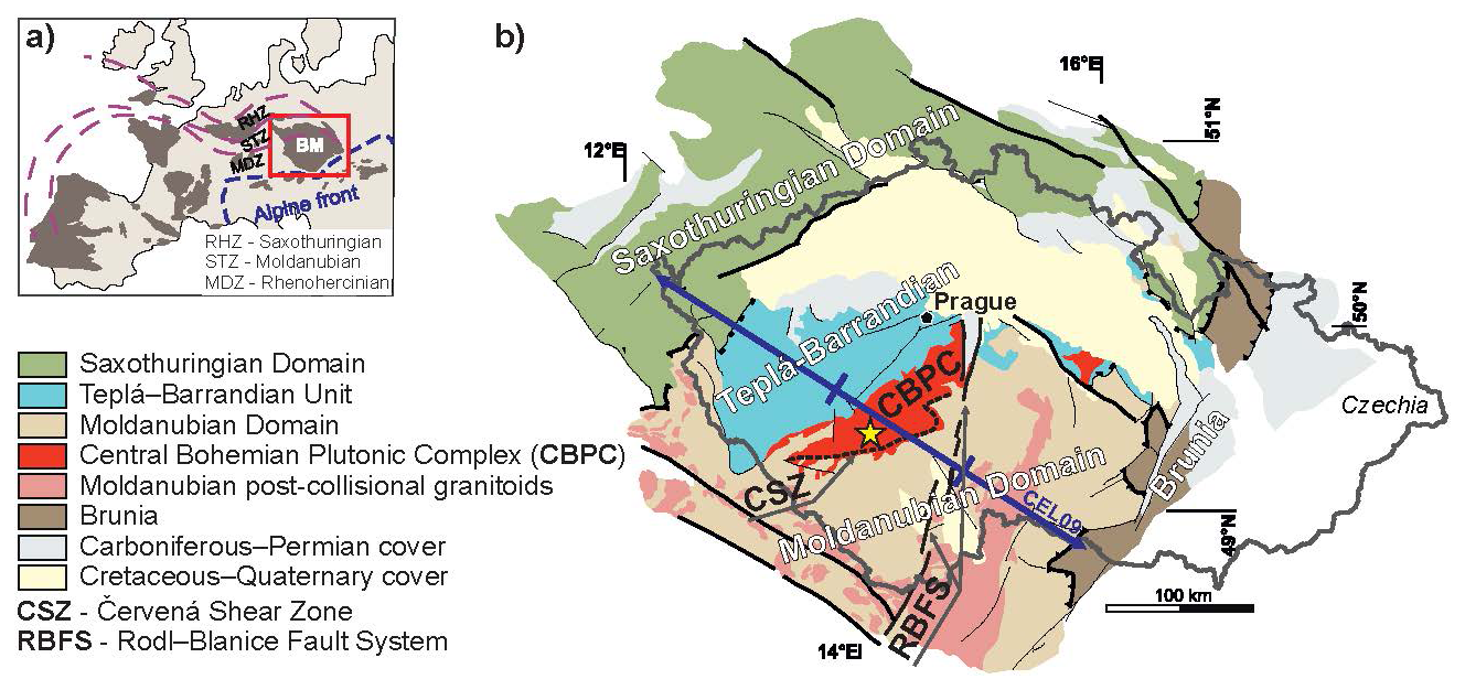
Figure 1(a) Schematic sketch of the European Variscides with the Bohemian Massif (red box) in the eastern edge. (b) Simplified geological map of the Bohemian Massif with individual tectonic units (modified after Machek et al., 2022). The Mirotice earthquakes are marked by a yellow star; the violet line marks the CEL09 seismic profile from the CELEBRATION 2000 experiment (Hrubcová et al., 2005). The Czechia border is indicated by a grey curve.
In this study, we present a crowdsourcing-based analysis of two unusual earthquakes near Mirotice in the southern Bohemian Massif, Czechia: an ML 3.5 event in 2024 and an ML 3.1 event in 2025 (Figs. 1 and 2). Both earthquakes originated in the deep crust and were widely felt across southern and central Bohemia, providing a valuable opportunity to investigate the spatial distribution of macroseismic effects and their relationship to the regional geological structure. Studies of the deep European Variscan crust indicate that pre-Permian thrusts exposed at the surface may root in the lower crust, at the Moho, or even within the upper mantle (Meissner and Wever, 1986). This underlines the importance of investigating the deep structure of the Bohemian Massif in order to better constrain its tectonic evolution and to delineate deep, steeply dipping tectonic boundaries that are otherwise difficult to identify. Our results demonstrate the potential of crowdsourced macroseismic data to reveal deep-seated geological structures that influence seismic-wave propagation in regions of sparse seismicity and limited instrumental observations.
Present-day seismicity within the Bohemian Massif is low, dominated by weak intraplate earthquakes, mostly confined to the upper crust (<12 km), and concentrated mainly along the massif margins (CZEQ catalogue, 2024; Fig. 2). In central and southern Bohemia, no seismotectonicaly active structures has been documented and only very few seismotectonic structures were observed in SW Bohemian Massif (Málek et al., 2018). More significant seismicity is limited to western Bohemia/Vogtland, where earthquake swarms are linked to the ascent of mantle-derived fluids migrating along deep crustal structures (Fischer et al., 2014), and to the eastern Sudetes (Fig. 2). Consequently, large parts of the internal structure of the Bohemian Massif remain seismically inactive. For this reason, seismic stations within the Bohemian Massif (excluding the above active regions) primarily serve regional seismic monitoring.
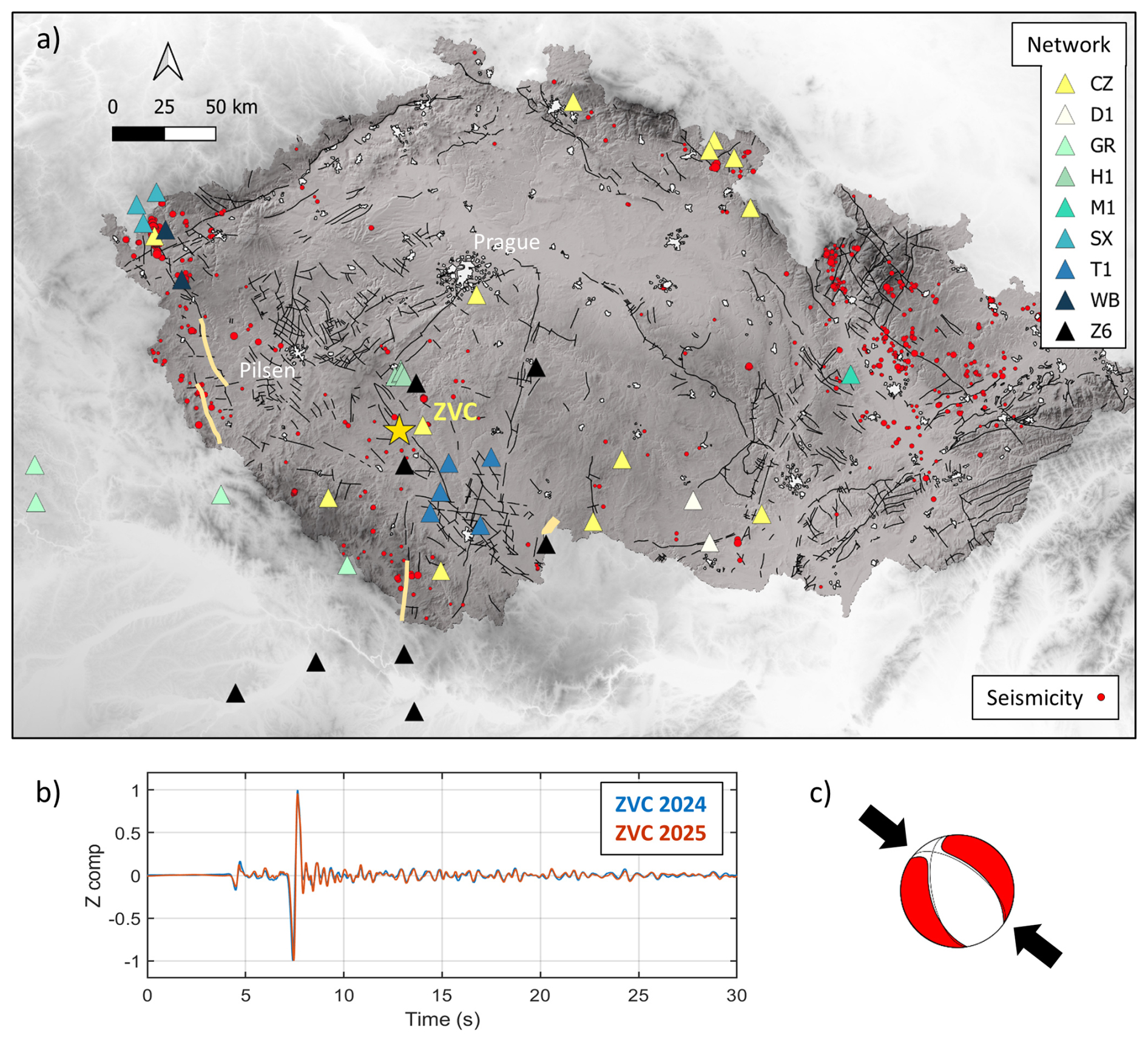
Figure 2(a) Seismicity in Czechia with ML in range 0.5–4.8 during the 2000–2024 period (CZEQ catalogue, 2024; red circles scaled by magnitude); Mirotice earthquakes denoted by yellow star. Triangles indicate seismic stations used for earthquake location and focal mechanism calculations color-coded by network (for network codes see text). Orange curves indicate seismotectonic lines in central and southern Bohemia (after Málek et al., 2018). (b) Seismic waveforms (filtered 0.5–2.0 Hz and scaled to maximum amplitude) of the Mirotice earthquakes in 2024 (ML 3.5) and 2025 (ML 3.1) recorded by station ZVC. Note similar waveform shape that suggests a similar source location and focal mechanism for both events. (c) Source mechanism of the Mirotice earthquakes; the arrows indicate the orientation of the regional maximum horizontal stress (SHmax; after Heidbach et al., 2016).
3.1 Mirotice 2024 Earthquake
On 7 March 2024, shortly before noon local time (10:41:41 GMT), an earthquake of magnitude ML 3.5 occurred in southern Bohemia (Czechia). The epicentre (49.42° N, 14.05° E) was located southeast of Mirotice town with the hypocentral depth of 24.5±1.5 km. Subsequent analysis identified four minor aftershocks with ML 0.5 occurring within one hour of the main shock, followed by a very weak event (ML −0.1) about 12 h later. The latest aftershock (ML 0.4) was recorded more than three weeks later, on 29 March 2024 at 17:51 GMT.
3.2 Mirotice 2025 Earthquake
The second earthquake (magnitude ML 3.1) occurred on 24 April 2025 at 17:32:47.3 GMT. This event originated essentially at the same location (49.42° N, 14.04° E) and at a comparable hypocentral depth of 24.5±1.5 km. The main shock was followed by four weak aftershocks (maximum ML 0.3), two occurring immediately after the main shock and two recorded one day later.
Due to sparse seismicity and limited seismic stations, the earthquake locations and focal mechanisms (Fig. 2) were calculated from stations belonging to various networks: the Czech Regional Seismic Network (CZ, 1973), Saxon Seismic Network (SX, 2001), German Regional Network (GR, 1976), and two Czech local seismic networks: WEBNET (WB, 1991) and MONET (M1, 2017). Additionally, we incorporated data from temporary station network (Schlömer et al., 2022) from the ongoing AdriaArray experiment (Kolínský et al., 2025; Vecsey et al., 2025), as well as stations from local industrial networks (T1, 1991; D1, 2014 and H1, 2017).
The epicentral coordinates of both events were obtained from the bulletin of the Institute of Physics of the Earth. Hypocentre locations were determined using the Hypo3d program (Firbas and Werl, 1988), based on the arrival times recorded at 23 stations. The calculations used a simple 1D gradient velocity model, regionally calibrated using observed travel times from deep seismic refraction experiments (Hrubcová et al., 2005) and quarry blasts. The reliability of the depth estimates was further assessed by comparing the observed travel times of the depth phase (sP) at epicentral distances of 140–210 km with theoretical travel times derived from several alternative velocity models. Additional support for the accuracy of the depth determination was provided by the consistency of the optimal focal mechanism solutions derived from both full-waveform and first-arrival inversions.
3.3 Mirotice 2012 Earthquake
The 2024 and 2025 Mirotice earthquakes were preceded by an earlier event in 2012. This earthquake occurred on 17 March 2012 at 00:56:31.8 GMT and was located at nearly the same epicentral position, at 49.401° N, 14.026° E. According to catalog of Institute of Physics of the Earth (CZEQ, 2024), the event originated at a depth of 19 km and had a small magnitude of ML 1.7.
3.4 Focal mechanisms
Focal mechanisms were determined through full waveform moment tensor inversion using the Bayesian ISOLA method (Vackář et al., 2017), based on waveform data from 12 broadband seismic stations at epicentral distances of 11–70 km. The inversion employed velocity model derived from nearby CEL09 refraction and wide-angle reflection profile (Fig. 1) of the CELEBRATION experiment (Hrubcová et al., 2005), which improved the waveform fit. The results indicate that both events were characterized by normal faulting on a NW–SE striking fault plane with strike 169° and dip 50° and 67° for respective earthquake (Fig. 2c; Table 1). Similar focal mechanism was obtained from P-wave first-motion polarities recorded at 47 stations with slightly different velocity model (strike 164°, dip 51°).
Table 1Focal mechanisms of the 2024 and 2025 Mirotice earthquakes from waveform inversion.

The earthquakes that occurred near Mirotice in 2024 and 2025 were unusual for the region in terms of their location, depth, and felt intensity, and therefore attracted considerable scientific interest as well as public attention. Macroseismic effects were documented through 1512 questionnaires for the 2024 event and 1679 questionnaires for the 2025 event, collected via online forms or smartphone application provided by the Institute of Geophysics of the Czech Academy of Sciences (IG CAS) (https://www.ig.cas.cz/makroseismicky-dotaznik/, last access: July 2026). In both cases, observations were submitted voluntarily. The public participation was encouraged through media interviews regularly following stronger or unusual events in Czechia, in which people are invited to complete this questionnaire. The approach supports the reliability of the dataset, as evidenced by the even higher reporting rate for the weaker 2025 event.
The shaking was reported over distances of several tens of kilometres. Responses were collected up to 70–100 km from the epicentre, including Písek, Strakonice, and Tábor regions, as well as the Šumava Mountains (Fig. 3a and c). Respondents reported ground shaking of varying intensity (strong shaking in 17 % of cases and light shaking in 66 % for the 2024 event; light shaking in 58 % of cases for the 2025 event), swaying of lightweight objects, and clinking of dishes (30 % in 2024; 18 % in 2025), and, in some cases, hairline cracks in walls or plaster, particularly near the epicentre (2.5 % in 2024; <1 % in 2025). The shaking was frequently accompanied by rumbling to booming sounds, many residents also reported sounds resembling the passage of heavy vehicles or an explosion (∼90 % of cases both in 2024 and 2025). Earthquake-related sounds are commonly perceived near epicentres, even for very small events (e.g., Tosi et al., 2012). In our case, the large number of reports across the wide area where these sounds were detected suggests unusually efficient seismic wave propagation.
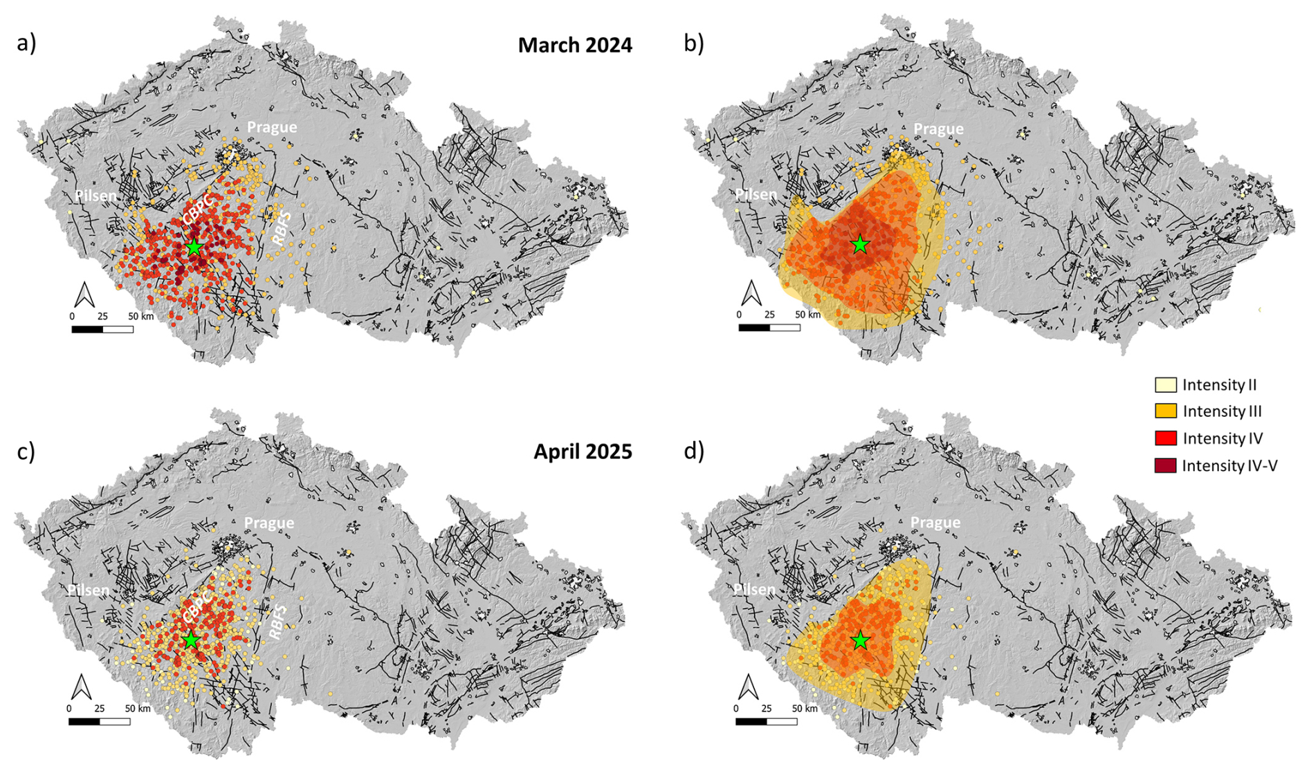
Figure 3The Mirotice earthquakes. (a, b) The ML 3.5 event in March 2024; (c, d) the ML 3.1 event in April 2025. (a, c) Spatial distribution of macroseismic observations (color-coded by individual intensities) collected by IG CAS. (b, d) macroseismic intensity according to the EMS–98 scale. The epicentres are marked in green. CBPC, Central Bohemian Plutonic Complex; RBFS, Rödl–Blanice Fault System.
Individual questionnaire responses were converted into macroseismic intensities according to the EMS–98 scale criteria (Grünthal, 1998). Intensities were initially assigned to individual reports and subsequently interpolated from individual values. Qualitative terms such as “few”, “many”, and “most” were quantified using three percentage not-overlapping ranges (0 %–20 %, 20 %–60 %, and 60 %–100 %), enabling a more quantitative assessment (Tosi et al., 2015). No correction for surface conditions like sedimentary effects was applied, as the area is generally underlain by crystalline rocks. Questionnaires lacking sufficient diagnostic information, containing inconsistent timing, duplicates, or those reporting effects not clearly attributable to the earthquake were excluded from the analysis (after Tosi et al., 2024). On average, only ∼2 % of the questionnaires were discarded, which demonstrates the reliability of the data provided by citizens.
Reports indicating light shaking felt by few persons at rest, but without movement of objects, were assigned intensity III (“weak”); scarcely felt earthquake, perceived only by very few individuals with no reported object effects or damage were assigned intensity II. Reports of strong shaking felt by many indoors, accompanied by rattling of windows, doors, or dishes and slight movement of lightweight objects, were assigned intensity IV (“largely observed”). An intensity of IV–V was assigned in areas with numerous reports indicating clear movement of unsecured objects, overturning of small items, or rare non-structural damage (e.g., hairline cracks in plaster), but without fully satisfying the criteria for intensity V (“strong”). Reports indicating that the earthquake was “not felt” are particularly valuable for estimating macroseismic intensity at lower intensity levels, where the assessment is commonly based on the proportion of people perceiving the shaking (e.g., Grünthal, 1998; Tosi et al., 2015). In our case, the “not felt” reports referred to cases with no perceived shaking, no object motion, and no damage, but only acoustic effects resembling heavy transport vehicles or explosion. Because acoustic effects alone are not diagnostic for the EMS-98 intensity assignment, these reports were treated separately as “heard-only” observations and were not used in determining locality intensity. When multiple effects were reported, intensities were assigned conservatively, based on object or damage-related indicators. The final locality intensity was taken as the modal value of all retained responses.
The maximum macroseismic intensity, assessed using the EMS–98 scale (Grünthal, 1998), reached IV–V for the stronger 2024 earthquake and IV for the weaker 2025 event (Fig. 3b and d). However, the most notable feature was not the intensity level itself, but the distinctly non-circular distribution of reported observations. Although the 2024 event was observed farther west than the 2025 event, both earthquakes showed an uneven spatial pattern that was not controlled by population density (Fig. 4).
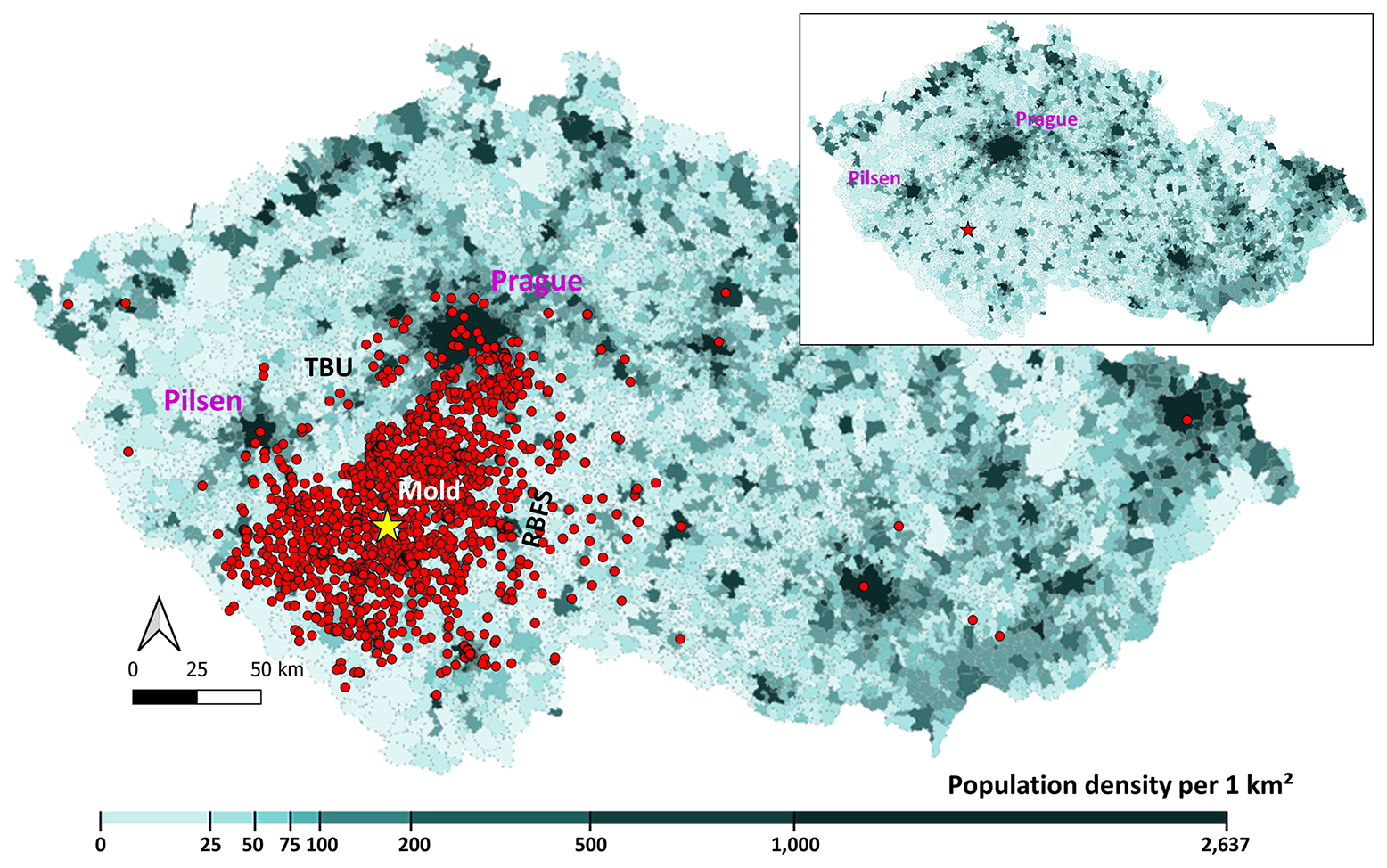
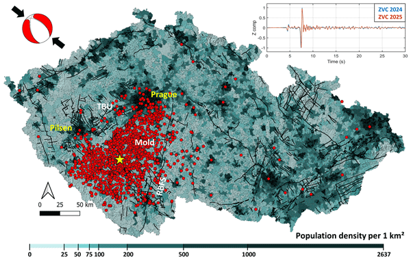
Figure 4Spatial distribution of macroseismic observations (red points) for both 2024 and 2025 Mirotice earthquakes (yellow star), superimposed on map of population density (people per km2; https://data.gov.cz/, last access: January 2026). Note trapezoidal patter of the observations delimited from the west by the Teplá–Barrandian (TBU)/Moldanubian (Mold) boundary and from the east by the Rödl–Blanice Fault System (RBFS) independent of population distribution. Inset shows the population density without observations. Note generally low population density in southern Bohemia with high observations and higher population density in the west at Pilsen region with sparse observations.
The area near epicentre is rural, sparsely but relatively evenly populated, with population densities of ∼ 20–50 persons per km2 and only a few towns present (Fig. 4, inset). Therefore, we did not apply any correction for population density. In contrast, farther west, particularly towards the Pilsen region, population density increases markedly, yet macroseismic observations were largely absent (Fig. 4). Normalizing the macroseismic observations by population density would make this contrast even more pronounced, further emphasizing the anomalous character of the observed spatial pattern.
5.1 Tectonic setting
The earthquakes occurred in the southern Bohemian Massif, which formed between 500–250 Ma during the convergence of Gondwana and Baltica. Its development was shaped by Neoproterozoic active margin of northern Gondwana, Cambro–Ordovician extension, Devonian subduction, and the Carboniferous underthrusting of the Saxothuringian microcontinent (Edel et al., 2018; Schulmann et al., 2014; Soejono et al., 2020). The Bohemian Massif is divided into four west-to-east lithotectonic units: the Neoproterozoic to Palaeozoic Saxothuringian Domain, the Ediacaran to Lower Palaeozoic Teplá–Barrandian Unit (TBU), the Variscan crustal Moldanubian Domain, and the Neoproterozoic to Palaeozoic Brunovistulicum (Hajná et al., 2017; Hanžl et al., 2019; Schulmann et al., 2014). The closure of the Saxothuringian ocean and subsequent continental underthrusting created the Central Bohemian Plutonic Complex (CBPC) magmatic arc at the Teplá–Barrandian–Moldanubian boundary (Schulmann et al., 2014; Žák et al., 2014).
The earthquake epicentral area is located within the Central Bohemian Plutonic Complex (CBPC), specifically in the Mirotice complex, near the NE–SW trending boundary (∼25 km east) between the Teplá–Barrandian Unit and the Moldanubian Domain (Fig. 1). The evolution of CBPC is characterized by the intrusion of Late Devonian plutons of magmatic arc affinity and voluminous syntectonic early Carboniferous arc plutons during regional vertical transpression into Neoproterozoic and Early Palaeozoic metasedimentary successions of subhorizontal structural record (Žák et al., 2014; Tomek et al., 2015). This resulted in deep-seated steeply dipping NE–SW oriented boundary separating CBPC in the east from contrasting lithologies of the Teplá–Barrandian Unit in the west.
The transpression regime was later replaced by ductile normal shearing along the Červená Shear Zone, which facilitated exhumation of high grade Moldanubian Domain and formed eastern boundary of CBPC (Žák et al., 2014; Fig. 1). In the study area, the Moldanubian is characterized by mostly shallow to subhorizontal structures and lithological contacts (Schulmann et al., 2014). The eastern margin of the region is further disrupted by the large scale NNE–SSW trending Rödl–Blanice Fault System, which developed during late Variscan tectonic evolution and was subsequently reactivated during the Cretaceous and Miocene (Prachař, 2022).
5.2 Structure from active seismic experiments
The deep crustal structure of the Bohemian Massif has been investigated by several active seismic profiling (e.g., Tomek et al., 1997; Růžek et al., 2003, 2007; Hrubcová et al., 2005; Vavryčuk et al., 2004). These studies revealed higher P-wave velocities with lower vertical gradient in the Moldanubian crust, reflecting the dominance of crystalline rocks exposed at the surface. The Moho beneath this unit forms a sharp first-order discontinuity reaching maximum depths to 39 km (Hrubcová et al., 2005). This coincides with minimum surface heat flow values of <50 mW m−2 (Čermák, 1977), suggesting cold and mechanically strong Moldanubian lithosphere (Babuška and Plomerová, 2000).
In contrast, the Teplá–Barrandian Unit is characterized by higher near-surface velocity gradients, consistent with its Palaeozoic volcano-sedimentary sequences. The Moho beneath this unit is shallower as documented along the refraction CEL09 profile (Hrubcová et al., 2005, 2017). In addition, two middle crustal reflectors, characterized by modest velocity contrasts (∼0.15–0.3 km s−1), are identified along CEL09 at depths of ∼7–13 and 17–20 km across much of the region.
6.1 Geological control on macroseismic distribution
The 2024 and 2025 macroseismic observations provide insight into deep crustal structure of the Bohemian Massif. They are unevenly distributed around the epicentre, forming a trapezoidal pattern (Figs. 3 and 4). Their non-circular distribution is bounded by two major structures: the Teplá–Barrandian and Moldanubian contact in the west, expressed as a deep-seated lithological boundary, and the Rödl–Blanice Fault System in the east, expressed as a crustal-scale fault zone (Fig. 5). The enclosed area is dominated by intrusive felsic rocks, mainly granites and granodiorites of the Central Bohemian Plutonic Complex (CBPC), and high-grade Moldanubian metamorphic rocks. Their low seismic attenuation may promote efficient wave propagation and possibly resonant effects.
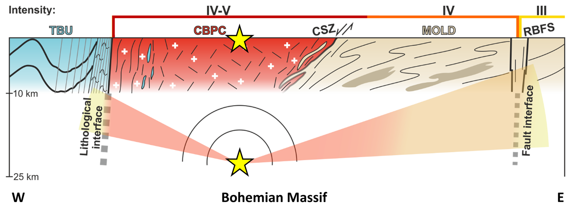
Figure 5Schematic cross-section along a segment of the CEL09 profile (see Fig. 1) showing principal geological structures of the Bohemian Massif (modified after Deiller et al., 2021; Žák et al., 2014) with spatial distribution of 2024 macroseismic intensity (on top) of the Mirotice earthquakes (yellow stars). Note two interpreted subvertical, crustal scale tectonic boundaries affecting seismic-wave propagation and attenuation: the lithological contact between the Teplá–Barrandian (TBU) with the Moldanubian (Mold) in the west, and the deep Rödl–Blanice Fault System (RBFS) in the east. CBPC, Central Bohemian Plutonic Complex; CSZ, Červená Shear Zone.
West of CBPC, the density of macroseismic observations sharply decreases. This area corresponds to the Teplá–Barrandian Unit, dominated by early Palaeozoic sedimentary formations with steeply oriented, highly anisotropic deformation structures near the contact (Fig. 5). This contrast suggests increased seismic attenuation within the Teplá–Barrandian Unit. The contrasting lithologies along this NW–SE-trending contact are also expressed in gravity and, particularly, in geomagnetic data, pointing to the deep character of this zone (Bucha and Blížkovský, 1994; Švancara et al., 2021).
To the east, attenuation coincides with the N–S-trending Rödl–Blanice Fault System, indicating a crustal-scale discontinuity. The macroseismic pattern therefore delineates subvertical structures that are not clearly resolved by conventional seismic investigations.
6.2 Population density and radiation effects
The epicentral region is sparsely and relatively evenly populated. However, and quite importantly, the main asymmetry in the macroseismic observations cannot be explained by population density because the more densely populated area toward Pilsen region contains few or no macroseismic reports. Normalization by population density therefore enhances rather than removes the observed contrast.
The asymmetric distribution may partly reflect the focal-mechanism radiation pattern, particularly the S-wave radiation toward the southwest and northeast. However, the sharp termination of observations along two old tectonic structures, independently of population density, indicates a strong structural control on seismic-wave propagation.
Strong reflections from the Teplá–Barrandian–Moldanubian contact represent another possible explanation, but they are unlikely given the geometry. The earthquakes originated at depths of ∼24 km, and ∼25 km horizontally from the contact, whose subvertical geometry is unfavourable for reflecting substantial shear-wave energy back toward the surface from such nearby sources.
Although smaller in magnitude, the 2025 earthquake (ML 3.1) was reported more frequently than the 2024 event (ML 3.5). Together with acoustic phenomena reported in ∼ 90 % of observations, this indicates efficient transmission of seismic energy from depth. It also suggests a relatively homogeneous crustal medium within the Moldanubian Domain, particularly the CBPC, facilitating both seismic-wave propagation and acoustic signals.
The attenuation observed within the Teplá–Barrandian Unit resembles regional patterns identified in deep seismic studies of the Bohemian Massif and Pannonian Basin (Beránek and Zátopek, 1981; Hrubcová et al., 2005, 2010). These studies showed efficient propagation through crystalline rocks of the Bohemian Massif and strong attenuation within sedimentary sequences of the Pannonian Basin.
6.3 Deep origin of Mirotice earthquakes
The Mirotice earthquakes are rare in the region and unusual within the Bohemian Massif because of their large focal depths of ∼24 km. Their occurrence at such depths may reflect the low regional geothermal gradient (Čermák, 1977), which allows brittle failure to occur within the lower crust. Their hypocentres coincide with a reflective interface identified along the CEL09 seismic profile of the CELEBRATION 2000 experiment (Hrubcová et al., 2005), which passes close to the epicentral area (Fig. 1). This interface may represent a structural or rheological discontinuity controlling earthquake nucleation. A persistent deep-seated source is further supported by the small 2012 earthquake, which originated in the same area.
6.4 Focal mechanisms and regional stress
The two earthquakes have nearly identical focal mechanisms, consistent with their similar waveforms recorded at the nearby ZVC station (Fig. 2b). Both indicate normal faulting on a NW–SE-striking plane (Fig. 2c; Table 1). The inferred stress regime is characterized by a vertical maximum principal stress, a NW–SE-oriented intermediate principal stress, and a minimum horizontal principal stress perpendicular to the fault strike. This geometry is consistent with normal faulting at lower-crustal depths, where lithostatic loading controls the vertical stress, while the horizontal stresses retain the regional orientation. The regional stress field is influenced by far-field compression associated with Africa–Eurasia convergence with SHmax predominantly oriented NW–SE across central Europe (Müller et al., 1992; Heidbach et al., 2016).
The 2024 and 2025 Mirotice earthquakes provide valuable insight into the deep crustal structure of the Bohemian Massif and demonstrate the potential of crowdsourced macroseismic observations for investigating crustal structure. The analysis brings three major achievements.
-
Despite occurring in a region generally considered seismically non-active and characterized by relatively low population density, both earthquakes attracted significant public attention, resulting in a high number of completed questionnaires.
-
The uneven spatial pattern of macroseismic observations, which was not controlled by population density, proved highly informative and showed a clear correlation with major geological structures.
-
Both earthquakes occurred at unusually large depths, in the middle to lower crust below 24 km. They also showed very similar focal mechanisms and originated from nearly the same location, together with the small event in 2012. Their magnitudes, particularly ML 3.5 for the 2024 event, are unexpected for a region generally considered seismically inactive.
The earthquakes occurred within the Moldanubian crystalline basement, inside the Central Bohemian Plutonic Complex (CBPC), slightly west of the deepest Moldanubian root and about 25 km east of its contact with the Teplá–Barrandian Unit. Their large focal depths, normal-faulting mechanisms, and efficient seismic-wave propagation are consistent with the low geothermal gradient and deep crystalline structure of the CBPC. The sharply delimited macroseismic observations outlines major crustal-scale boundaries: the deep Moldanubian–Teplá–Barrandian contact to the west and the Rödl–Blanice Fault System to the east. Together, these observations reveal deep, subvertical structures within the Bohemian Massif that are not easily resolved by conventional seismic investigations. The results demonstrate that major crustal-scale tectonic boundaries strongly influence seismic wave propagation and attenuation, and highlight the value of crowdsourced data for studying deep crustal processes in regions of sparse intraplate seismicity.
Macroseismic questionnaires related to this paper are in Czech and available at request from the authors.
Conceptualization: PH; Data curation: PH, JV, AP, HKE, PS, and JZ; Formal analysis: PH, JV, AP, and PS; Funding acquisition: PH; Writing original draft and visualisation: PH and MM; Writing review and editing: PH, MM, JV, HKE, PS, and JZ.
The contact author has declared that none of the authors has any competing interests.
Publisher's note: Copernicus Publications remains neutral with regard to jurisdictional claims made in the text, published maps, institutional affiliations, or any other geographical representation in this paper. The authors bear the ultimate responsibility for providing appropriate place names. Views expressed in the text are those of the authors and do not necessarily reflect the views of the publisher.
The authors gratefully acknowledge all respondents who completed the macroseismic questionnaire on the website of the Institute of Geophysics of the Czech Academy of Sciences, thereby contributing to the determination of macroseismic intensities for the 2024 and 2025 Mirotice earthquakes. The authors also thank the AdriaArray Seismology Group (https://orfeus.readthedocs.io/en/latest/adria_array_main.html, last access: October 2025), and operators of seismic networks (CZ, 1973; GR, 1976; SX, 2001; WB, 1991; M1, 2017; Z6, 2022; T1, 1991; D1, 2014; H1, 2017) for providing data from their stations.
This study was supported by the Czech Academy of Sciences, programme Strategie AV21 No. VP30 Dynamic Planet Earth.
This paper was edited by Simone Pilia and reviewed by two anonymous referees.
Babuška, V. and Plomerová, J.: Saxothuringian–Moldanubian suture and predisposition of seismicity in the western Bohemian Massif, Stud. Geophys. Geod., 44, 292–306, 2000.
Beránek, B. and Zátopek, A.: Earth's crust structure in Czechoslovakia and central Europe by methods of explosion seismology, in: Geophysical Synthesis in Czechoslovakia, edited by: Zátopek, A., Veda, Bratislava, Slovakia, 253– 264, 1981.
Bucha, V. and Blížkovský, M.: Crustal Structure of the Bohemian Massif and the West Carpathians, Academia Praha, Prague, ISBN-13: 978-3642789977, 1994.
Čermák, V.: Geothermal Models of the Bohemian Massif (Variscan) and the Western Carpathians (Alpine) and their Mutual Relation, Tectonophysics, 41, 127–137, 1977.
Cifelli, F., Donati, S., Funiciello, F., and Tertulliani, A.: High-Density Macroseismic Survey in Urban Areas, Part 2: Results for the City of Rome, Italy, B. Seismol. Soc. Am., 90, 298–311, 2000.
CZEQ catalogue: Catalogue of Earthquakes in the Czech Republic since 2000, https://doi.org/10.48790/86v9-3g98, 2024.
CZ: Institute of Geophysics, Academy of Sciences of the Czech Republic, Charles University in Prague, Institute of Geonics, Institute of Physics of the Earth Masaryk University, & Institute of Rock Structure and Mechanics, Czech Regional Seismic Network, International Federation of Digital Seismograph Networks [data set], https://doi.org/10.7914/SN/CZ, 1973.
D1: Institute of Physics of the Earth Masaryk University (Czech), IPE_EDU, International Federation of Digital Seismograph Networks [data set], https://doi.org/10.7914/SN/D1, 2014.
Deiller, P., Štípská, P., Ulrich, M., Schulmann, K., Collett, S., Peřestý, V., Hacker, B., Kylander-Clark, A., Whitechurch, H., Lexa, O., Pelt, E., and Míková, J.: Eclogite subduction wedge intruded by arc-type magma: The earliest record of Variscan arc in the Bohemian Massif, Gondwana Res., 99, 220–246, https://doi.org/10.1016/j.gr.2021.07.005, 2021.
Edel, J. B., Schulmann, K., Lexa, O., and Lardeaux, J. M.: Late Palaeozoic palaeomagnetic and tectonic constraints for amalgamation of Pangea supercontinent in the European Variscan belt, Earth-Sci. Rev., 177, 589–612, https://doi.org/10.1016/j.earscirev.2017.12.007, 2018.
Firbas, P. and Werl, M.: HYPO3D, rev. 9.00. Lokalizace ve 3D blokovém prostředí. Etapová zpráva, Geofyzika n.p., Brno, https://github.com/firbas/hypo3d (last access: October 2025), 1988.
Fischer, T., Horálek, J., Hrubcová, P., Vavryčuk, V., Bräuer, K., and Kämpf, H.: Intra-continental earthquake swarms in West-Bohemia and Vogtland, A review, Tectonophysics, 611, 1–27, https://doi.org/10.1016/j.tecto.2013.11.001, 2014.
GR: Federal Institute for Geosciences and Natural Resources, German Regional Seismic Network (GRSN), Bundesanstalt für Geowissenschaften und Rohstoffe, https://doi.org/10.25928/mbx6-hr74, 1976.
Grünthal, G.: European Macroseismic Scale 1998 (EMS-98), Cahiers du Centre Européen de Géodynamique et de Séismologie 15, Helfent-Betrange (Luxembourg), ISBN 2-87977-008-4, 1998.
Guan, X. and Chen, C.: Using social media data to understand and assess disasters, Nat. Hazards, 74, 837–850, https://doi.org/10.1007/s11069-014-1217-1, 2014.
H1: Brož, M., Štrunc, J. (in Czech): Methodology and results of long-term seismological monitoring at underground gas storage Háje – Innogy.cz, Exploration Geophysics, Remote Sensing and Environment, XXIV, https://doi.org/10.26345/EGRSE-001-17-101, 2017.
Hajná, J., Žák, J., and Dörr, W.: Time scales and mechanisms of growth of active margins of Gondwana: A model based on detrital zircon ages from the Neoproterozoic to Cambrian Blovice accretionary complex, Bohemian Massif, Gondwana Res., 42, 63–83, https://doi.org/10.1016/j.gr.2016.10.004, 2017.
Hanžl, P., Janoušek, V., Soejono, I., Buriánek, D., Svojtka, M., Hrdličková, K., Erban, V., and Pin, C.: The rise of the Brunovistulicum: age, geology, petrology and geochemical character of the Neoproterozoic magmatic rocks of the Central Basic Belt of the Brno Massif, Int. J. Earth Sci., 108, 1165–1199, https://doi.org/10.1007/s00531-019-01700-2, 2019.
Hao, H. and Wang, Y.: Leveraging multimodal social media data for rapid disaster damage assessment, Int. J. Disast. Risk Re., 51, 101760, https://doi.org/10.1016/j.ijdrr.2020.101760, 2020.
Heidbach, O., Rajabi, M., Reiter, K., Ziegler, M., and WSM Team: World Stress Map Database Release 2016, V.1.1., GFZ Data Services, https://doi.org/10.5880/WSM.2016.001, 2016.
Hrubcová, P., Środa, P., Špičák, A., Guterch, A., Grad, M., Keller, G. R., Brückl, E., and Thybo, H.: Crustal and uppermost mantle structure of the Bohemian Massif based on CELEBRATION 2000 data, J. Geophys. Res., 110, B11305, https://doi.org/10.1029/2004JB003080, 2005.
Hrubcová, P., Środa, P., Grad, M., Geissler, W. H., Guterch, A., Vozár, J., Hegedűs, E., and Sudetes 2003 Working Group: From the Variscan to the Alpine Orogeny: Crustal structure of the Bohemian Massif and Western Carpathians in the light of the SUDETES 2003 seismic data, Geophys. J. Int., 183, 611–633, https://doi.org/10.1111/j.1365-246X.2010.04766.x, 2010.
Hrubcová, P., Geissler, W. H., Bräuer, K., Vavryčuk, V., Tomek, Č., and Kämpf, H.: Active magmatic underplating in western Eger Rift, Central Europe, Tectonics, 36, 2846–2862, https://doi.org/10.1002/2017TC004710, 2017.
Kankanamge, N., Yigitcanlara, T., Goonetilleke, A., and Kamruzzaman, M.: Can volunteer crowdsourcing reduce disaster risk? A systematic review of the literature, Int. J. Disast. Risk Re., 35, 101097, https://doi.org/10.1016/j.ijdrr.2019.101097, 2019.
Kolínský, P., Meier, T., Agius, M. R., Bijedić, A., Bokelmann, G.; Borleanu, F., Brnović, D., Cambaz, M. D., Cammarano, F., Čarman, M., Cauzzi, C., Chernih, D., Csicsay, K., Cvijić Amulić, S., Czuba, W., Diaz, J., Dimitrova, L., Dushi, E., Evangelidis, C. P., Faccenna, C., Farfuliak, L., Friederich, W., Georgieva, G., Horn, N., Ivančić, I., Jia, Y., Kaviris, G., Kovács, I. J., Lebedev, S., Le Breton, E., Lukešová, R., Mazur, S., van der Meijde, M., Molinari, I., Mustafa, S., Nagel, T., Nielsen, S. B., Obermann, A., Papazachos, C., Parolai, S., Paul, A., Piromallo, C., Plicka, V., Rietbrock, A., Rondenay, S., Rossi, G., Rümpker, G., Schiffer, C., Schlömer, A., Sigloch, K., Silvennoinen, H., Sokos, E., Špaček, P., Stipčević, J., Tallarico, A., Tiira, T., Tilmann, F., Valčić, D., Wassermann, J., Wesztergom, V., Xhahysa, A., Živčić, M., and the AdriaArray Seismology Group: AdriaArray – a Passive Seismic Experiment to Study Structure, Geodynamics and Geohazards of the Adriatic Plate, Ann. Geophys., 68, DM555, https://doi.org/10.4401/ag-9284, 2025.
Kryvasheyeu, Y., Chen, H., Obradovich, N., Moro, E., Van Hentenryck, P., Fowler, J., and Cebrian, M.: Rapid assessment of disaster damage using social media activity, Science Advances, 2, e1500779, https://doi.org/10.1126/sciadv.1500779, 2016.
M1: Institute of Physics of the Earth Masaryk University Brno (IPE), MOravia NETwork (MONET), GFZ Data Services [data set], https://doi.org/10.14470/Z6115722, 2017.
Machek, M., Soejono, I., Sláma, J., and Žáčková, E.: Timing and kinematics of the Variscan orogenic cycle at the Moldanubian periphery of the central Bohemian Massif, J. Geol. Soc. London, 179, jgs2021-096, https://doi.org/10.1144/jgs2021-096, 2022.
Málek, J., Prachař, I., Vackář, J., and Mazanec, M.: Probabilistic assessment of seismic hazard at sites selected for the construction of a deep geological repository, Technical report, TZ 232/2018, MS SÚRAO (in Czech, with English abstract), 2018.
Meissner, R. and Wever, T.: Nature and development of the crust according to deep reflection data from the German Variscides, in: Reflection Seismology: A Global Perspective, edited by; Barazangi, M. and Brown, L., Geodyn. Ser., 13, AGU, Washington, D.C., 31–42, ISBN 978-1-118-67030-9, 1986.
Müller, B., Zoback, M. L., Fuchs, K., Mastin, L., Gregersen, S., Pavoni, N., Stephansson, O., and Ljunggren, C.: Regional patterns of tectonic stress in Europe, J. Geophys. Res., 97, 91JB01096, 11783–11803, 1992.
Prachař, I.: Rodl-Blanice Fault System, in: Faults of the Bohemian Massif – Source of Analytical Data on Main Faults and Faulted Areas with Seismogenic Potential, edited by: Špaček, P., Štěpančíková, P., and Prachař, I., IPE, Masaryk University, https://doi.org/10.48790/MWF4-SH44, 2022.
Růžek, B., Vavryčuk, V., Hrubcová, P., Zedník, J., and CELEBRATION Working Group: Crustal anisotropy in the Bohemian Massif, Czech Republic: Observations based on Central European Lithospheric Experiment Based on Refraction (CELEBRATION) 2000, J. Geophys. Res., 108, 2392, https://doi.org/10.1029/2002JB002242, 2003.
Růžek, B., Hrubcová, P., Novotný, M., Špičák, A., and Karousová, O.: Inversion of travel times obtained during active seismic refraction experiments CELEBRATION 2000, ALP 2002 and SUDETES 2003, Stud. Geophys. Geod., 51, 141–166, 2007.
Schlömer, A., Wassermann, J., Plomerová, J., Vecsey, L., Süle, B., Wéber, Z., Xhahysa, A., Rama, B., Tomanovic, M., Dedic, J., Mustafa, S., Fojtikova, L., Csicsay, K., Müller, J., van Laaten, M., Wegler, U., Meier, T., Mazur, S., Soni, T., and Schiffer, C.: AdriaArray Temporary Network: Albania, Austria, Czech Rep., Germany, Hungary, Kosovo, Montenegro, Slovakia, Poland, International Federation of Digital Seismograph Networks [data set], https://doi.org/10.7914/2cat-tq59, 2022.
Schulmann, K., Lexa, O., Janoušek, V., Lardeaux, J. M., and Edel, J. B.: Anatomy of a diffuse cryptic suture zone: an example from the Bohemian Massif, European Variscides, Geology, 42, 275–278, https://doi.org/10.1130/G35290.1, 2014.
Soejono, I., Machek, M., Sláma, J., Janoušek, V., and Kohút, M.: Cambro–Ordovician anatexis and magmatic recycling at the thinned Gondwana margin: new constraints from the Kouřim Unit, Bohemian Massif, J. Geol. Soc. London, 177, 325–341, https://doi.org/10.1144/jgs2019-037, 2020.
Švancara, J., Meurers, B., Bielik, M., and Špaček, P.: Gravity maps of the contact region of the Bohemian Massif, Eastern Alps, Vienna Basin and Western Carpathians, https://doi.org/10.48790/6RHA-GW96, 2021.
SX: University of Leipzig, Saxon Seismic Network (SXNET), International Federation of Digital Seismograph Networks [data set], https://doi.org/10.7914/SN/SX, 2001.
T1: Institute of Physics of the Earth Masaryk University (Czech), IPE_ETE, International Federation of Digital Seismograph Networks [data set], https://doi.org/10.7914/SN/T1, 1991.
Tomek, Č., Dvořáková, V., and Vrána, S.: Geological interpretation of the 9HR and 503 M seismic profiles in western Bohemia, J. Geol. Sci., Prague, 47, 43–51, 1997.
Tomek, F., Žák, J., and Chadima, M.: Granitic magma emplacement and deformation during early-orogenic syn-convergent transtension: The Staré Sedlo complex, Bohemian Massif, J. Geodyn., 87, 50–66, https://doi.org/10.1016/j.jog.2015.02.007, 2015.
Toshinawa, T., Taber, J. J., and Berrill, J. J.: Distribution of Ground Motion Intensity Inferred from Questionnaire Survey Recordings, and Microtremor Measurements – A Case Study in Christchurch, New Zealand, during the 1994 Arthurs Pass Earthquake, B. Seismol. Soc. Am., 87, 356–369, 1997.
Tosi, P., Sbarra, P., and De Rubeis, V.: Earthquake sound perception, Geophys. Res. Lett., 39, L24301, https://doi.org/10.1029/2012GL054382, 2012.
Tosi, P., Sbarra, P., De Rubeis, V., and Ferrari, C.: Macroseismic intensity assessment method for web questionnaires, Seismol. Res. Lett., 86, 985–990, https://doi.org/10.1785/0220140229, 2015.
Tosi, P., De Rubeis, V., and Sbarra, P.: HSIT system: Citizen Participation in Seismology for Data Collection and Enhanced Understanding of Earthquake Effects, J. Geoethics and Social Geosci., 2, https://doi.org/10.13127/jgsg-51, 2024.
Vackář, J., Gallovič, F., Burjánek, J., Zahradník, J., and Clinton, J.: Bayesian ISOLA: New tool for automated centroid moment tensor inversion, Geophys J. Int., 210, 693–705, https://doi.org/10.1093/gji/ggx158, 2017.
Vavryčuk, V., Hrubcová, P., Brož, M., Málek, J., and ALP 2002 Working Group: Azimuthal variation of Pg velocity in the Moldanubian, Czech Republic: observations based on a multi-azimuthal common-shot experiment, Tectonophysics, 387, 189–203, https://doi.org/10.1016/j.tecto.2004.06.015, 2004.
Vecsey, L., Środa, P., Plomerová, J., Bokelmann, G., Bociarska, M., Csicsay, K., Czuba, W., Fojtíková, L., Jedlička, P., Kampfová Exnerová, H., Kolínský, P., Kotek, J., Malinowski, S., Mendecki, M., Rewers, J., and Schützenhofer, D.: Northern Promontory of AdriaArray: Network Design and Realization, Ann. Geophys., 68, DM557, https://doi.org/10.4401/ag-9327, 2025.
WB: Institute of Geophysics, Academy of Sciences of the Czech Republic. West Bohemia Local Seismic Network (WEBNET), International Federation of Digital Seismograph Networks [data set], https://doi.org/10.7914/SN/WB, 1991.
Z6: Antje Schlömer, Joachim Wassermann, Jaroslava Plomerová, Luděk Vecsey, Bálint Süle, Zoltán Wéber, Anila Xhahysa, Besian Rama, Milena Tomanovic, Jovan Dedic, Shemsi Mustafa, Lucia Fojtikova, Kristian Csicsay, Jozef Müller, Marcel van Laaten, Ulrich Wegler, Thomas Meier, Stanislaw Mazur, Tanishka Soni, and Christian Schiffer, AdriaArray Temporary Network: Albania, Austria, Czech Rep., Germany, Hungary, Kosovo, Montenegro, Slovakia, Poland, International Federation of Digital Seismograph Networks [data set], https://doi.org/10.7914/2cat-tq59, 2022.
Žák, J., Verner, K., Janoušek, V., Holub, F. V., Kachlík, V., Finger, F., Hajná, J., Tomek, F., Vondrovic, L., and Trubač, J.: A plate-kinematic model for the assembly of the Bohemian Massif constrained by structural relationships around granitoid plutons, in: The Variscan Orogeny: Extent, Timescale and the Formation of the European Crust, edited by: Schulmann, K., Martínez Catalán, J. R., Lardeaux, J. M., Janoušek, V., and Oggiano, G., Geol. Soc. London Special Publications, 405, 169–196, https://doi.org/10.1144/SP405.9, 2014.
- Abstract
- Introduction
- Seismicity in the Bohemian Massif
- Unusual Earthquakes near Mirotice
- Macroseismic Observations
- Tectonic and Structural Context
- Discussion
- Conclusions
- Data availability
- Author contributions
- Competing interests
- Disclaimer
- Acknowledgements
- Financial support
- Review statement
- References
- Abstract
- Introduction
- Seismicity in the Bohemian Massif
- Unusual Earthquakes near Mirotice
- Macroseismic Observations
- Tectonic and Structural Context
- Discussion
- Conclusions
- Data availability
- Author contributions
- Competing interests
- Disclaimer
- Acknowledgements
- Financial support
- Review statement
- References